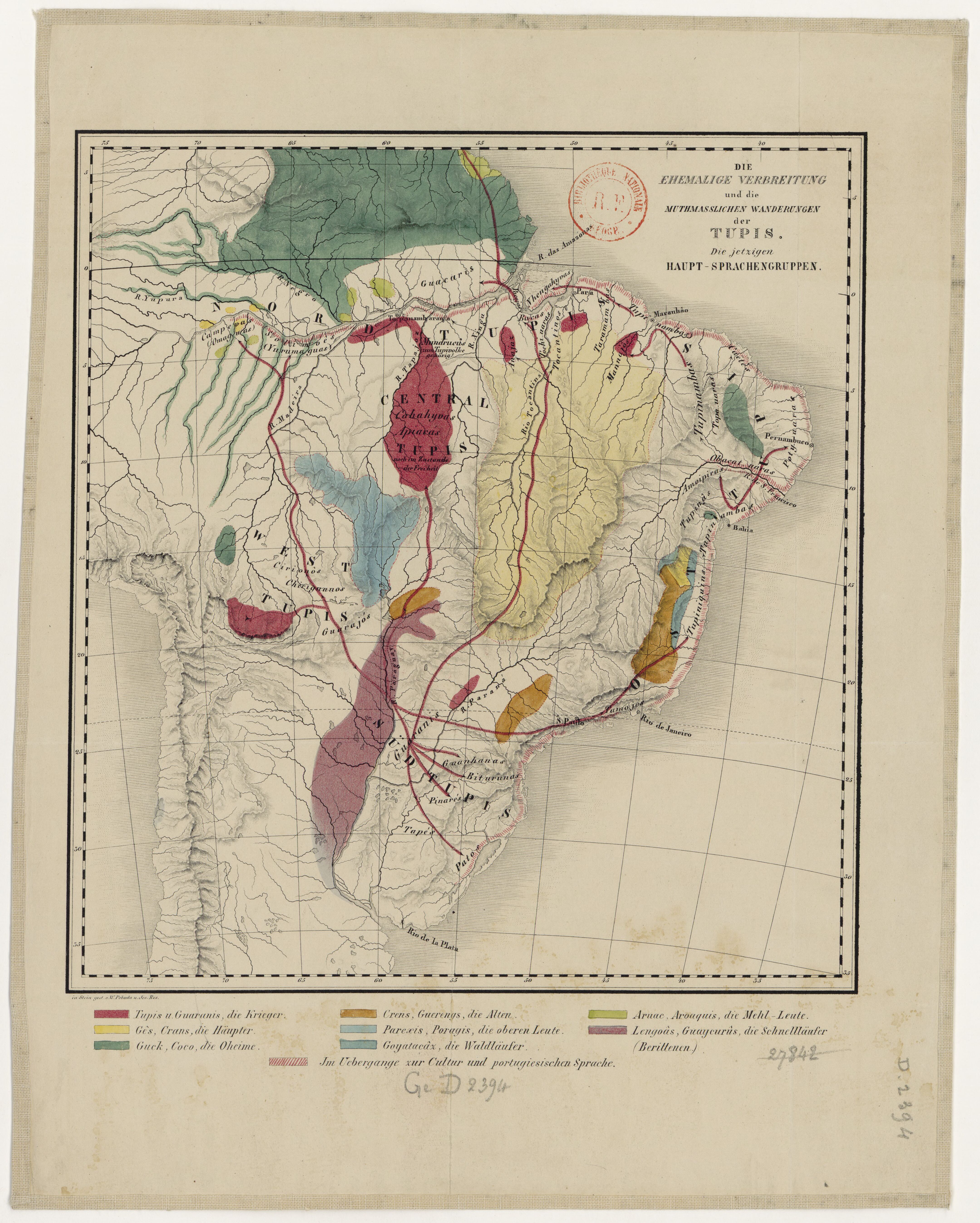
Dispossesions in the Americas

Dispossesions in the Americas

  • Home
  • Explore
  • About
  • Authors
  • Art
  • Bodies
  • Curricula
  • Cultural Heritage
  • Maps
  • Territories
Back to Explore
Map 1875

DIE EHEMALIGE VERBREITUNG und die MUTHMASSLICHEN WANDERUNGEN der TUPIS. Die jetzigen HAUPT-SPRACHENGRUPPEN.

  • POBEDA, W, ET AL.

Published: 1875

  • Download Image

Peoples

  • OMAGUAS
  • YURUMAGUAS
  • GUACARIS
  • MUNDRUCUS
  • TUPIVOLKE
  • NHENGAHYVAS
  • ANAJAZ
  • BOCAS
  • TOCHI-UARAS
  • TOCANTINOS
  • TARAMAMBAS
  • MANNAJOS
  • TUPINAMBAS
  • CAETES
  • POTY-UARAS
  • OBACAT-UARAS
  • TOPA-UARAS
  • CAHAHYVAS
  • APIARAS
  • TUPIS
  • AMOIPIRAS
  • TUPINAS
  • TAPINAMBAS
  • TUPINIQUINS
  • GUARAJOS
  • CHIRIGUANOS
  • CIRIONOS
  • GUARANIS
  • TAMOJOS
  • GUANHANAS
  • BITURUNAS
  • PINARES
  • TAPES
  • PATOS
  • GES
  • CRANS
  • GUCK
  • COCO
  • GUERENGS
  • PAREXIS
  • PORAGIS
  • GOYATACAX
  • ARUAC
  • AROAQUIS
  • LENGOAS
  • GUAYCURUS

Citation

Pobeda, W., and Jos. Res. "Die ehemalige Verbreitung und die muthmasslichen Wanderungen der Tupis: Die jetzigen Haupt-Sprachengruppen." Map. 1875. Accessed July 20, 2023. https://gallica.bnf.fr/ark:/12148/btv1b84412480/f1.item#.

  • Download Image

Reading in Spanish

Map 1875

DIE EHEMALIGE VERBREITUNG und die MUTHMASSLICHEN WANDERUNGEN der TUPIS. Die jetzigen HAUPT-SPRACHENGRUPPEN.

  • POBEDA, W, ET AL.

Published: 1875

  • Download Image
  • Download Image

Related Content

PUEBLO TEKO

PUEBLO TEKO

Map 2020
Izquyluca; Tenayuca. Distrito Federal, 1594

Izquyluca; Tenayuca. Distrito Federal, 1594

Map 1594
Indians in Cuba

Indians in Cuba

Map 1989
CAMPECHE

CAMPECHE

Map 2015
Northern Mexico and a Portion of Texas 1600-1750 Showing the approximate Locations of Indian tribes

Northern Mexico and a Portion of Texas 1600-1750 Showing the approximate Locations of Indian tribes

Map 1600 - 1750
YUCATÁN

YUCATÁN

Map 2015
Plate 8. The 18 tribes reported by the Berbice Arawak

Plate 8. The 18 tribes reported by the Berbice Arawak

Map 1700 - 1799
Mapa de Ubicacion de Grupos y Pueblos Indigenas en Aislamiento Voluntario

Mapa de Ubicacion de Grupos y Pueblos Indigenas en Aislamiento Voluntario

Map 2010

Dispossessions in the Americas

A project by

University of Pennsylvania

Copyright 2024

With support from

Mellon Foundation

Site design & development

Element 84

Art Credits

Pobeda, W., and Jos. Res. “Die ehemalige Verbreitung und die muthmasslichen Wanderungen der Tupis: Die jetzigen Haupt-Sprachengruppen.” Map. 1875. Accessed July 20, 2023. https://gallica.bnf.fr/ark:/12148/btv1b84412480/f1.item#.

Site Pages

  • Home
  • Explore
  • About
  • Authors
  • Art
  • Bodies
  • Curricula
  • Cultural Heritage
  • Maps
  • Territories