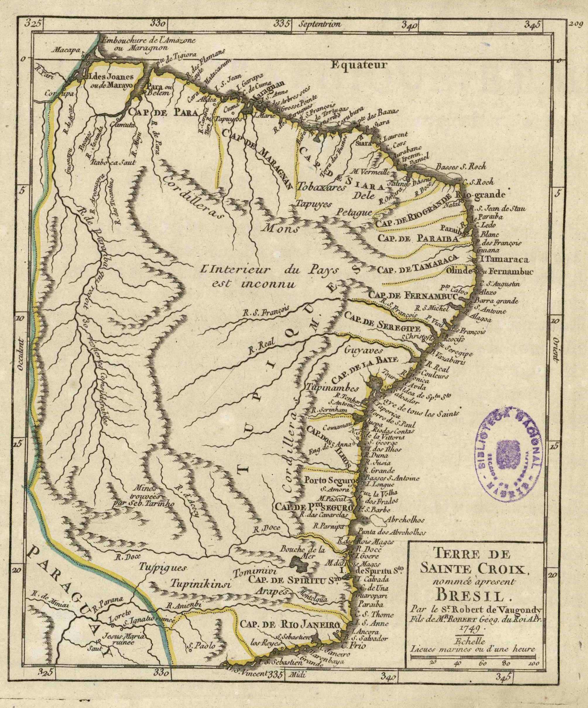
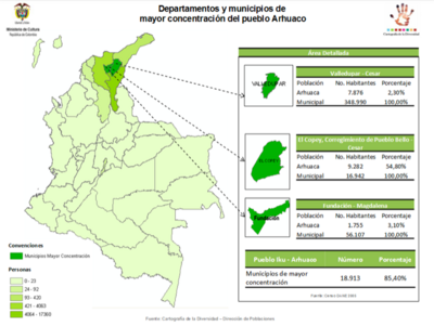
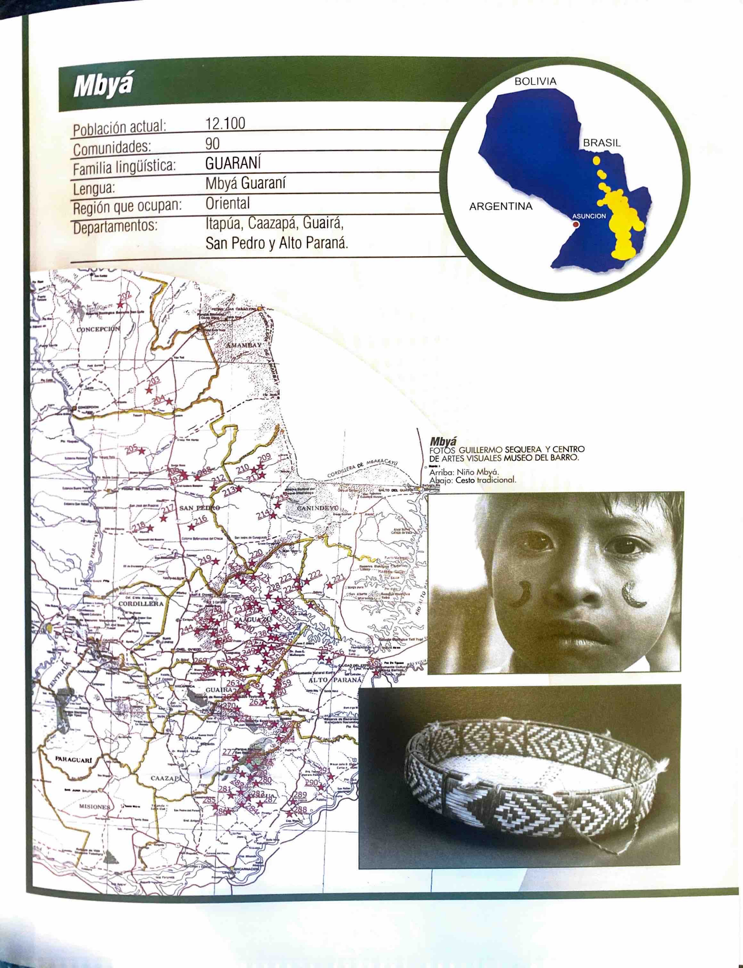
Dispossesions in the Americas

Dispossesions in the Americas

  • Home
  • Explore
  • About
  • Authors
  • Art
  • Bodies
  • Curricula
  • Cultural Heritage
  • Maps
  • Territories
Back to Explore
Map 1749

Terre de Sainte Croix, nommée apresent Bresil

  • DE VAUGONDY, ROBERT

Published: 1749

  • Download Image

Peoples

  • TUPINIKINSI
  • TUPIGUES
  • TOMIMIVI
  • ARAPES
  • TUPINAMBES
  • GUYAVES
  • PETAGUE
  • TAPUYES
  • TOBAXARES
  • TAPUYOS

Citation

de Vaugondy, Robert. "Terre de Sainte Croix, nommée apresent Bresil." Map. In Atlas Portatif Universel et Militaire, Composé d'après les meilleures Cartes, tant gravées que manuscrites, by Robert de Vaugondy, Durand, and Pissot. Paris: Robert de Vaugondy, 1749. Accessed July 14, 2023. http://bdh.bne.es/bnesearch/detalle/bdh0000001597.

  • Download Image

Reading in Spanish

Map 1749

Terre de Sainte Croix, nommée apresent Bresil

  • DE VAUGONDY, ROBERT

Published: 1749

  • Download Image
  • Download Image

Reading in Portuguese

Map 1749

Terre de Sainte Croix, nommée apresent Bresil

  • DE VAUGONDY, ROBERT

Published: 1749

  • Download Image

Peoples

  • TUPINIKINSI
  • TUPIGUES
  • TOMIMIVI
  • ARAPES
  • TUPINAMBES
  • GUYAVES
  • PETAGUE
  • TAPUYES
  • TOBAXARES
  • TAPUYOS

Citation

de Vaugondy, Robert. "Terre de Sainte Croix, nommée apresent Bresil." Map. In Atlas Portatif Universel et Militaire, Composé d'après les meilleures Cartes, tant gravées que manuscrites, by Robert de Vaugondy, Durand, and Pissot. Paris: Robert de Vaugondy, 1749. Accessed July 14, 2023. http://bdh.bne.es/bnesearch/detalle/bdh0000001597.

  • Download Image

Related Content

SÜD-AMERIKA, BL. 4

SÜD-AMERIKA, BL. 4

Map 1911
Mapa de la población total y porcentaje de indios;1776

Mapa de la población total y porcentaje de indios;1776

Map 1776
[Mapa de América del Sur desde el Ecuador hasta el Estrecho de Magallanes.]

[Mapa de América del Sur desde el Ecuador hasta el Estrecho de Magallanes.]

Map 1600
Departamentos y municipios de mayor concentración del pueblo Arhuaco

Departamentos y municipios de mayor concentración del pueblo Arhuaco

Map 2005
Mbyá

Mbyá

Map 2001
The modern departments of Ahuachapán, La Libertad, Santa Ana, and Sonsonate (highlighted in red) now contain the highest concentration of Indigenous communities in El Salvador.

The modern departments of Ahuachapán, La Libertad, Santa Ana, and Sonsonate (highlighted in red) now contain the highest concentration of Indigenous communities in El Salvador.

Map 2010
Mapa de la costa de la provincia de [Santa Marta con las bahías], Rios y Sitios

Mapa de la costa de la provincia de [Santa Marta con las bahías], Rios y Sitios

Map 1770
Manjui

Manjui

Map 2001

Dispossessions in the Americas

A project by

University of Pennsylvania

Copyright 2024

With support from

Mellon Foundation

Site design & development

Element 84

Art Credits

de Vaugondy, Robert. “Terre de Sainte Croix, nommée apresent Bresil.” Map. In Atlas Portatif Universel et Militaire, Composé d’après les meilleures Cartes, tant gravées que manuscrites, by Robert de Vaugondy, Durand, and Pissot. Paris: Robert de Vaugondy, 1749. Accessed July 14, 2023. http://bdh.bne.es/bnesearch/detalle/bdh0000001597.

Site Pages

  • Home
  • Explore
  • About
  • Authors
  • Art
  • Bodies
  • Curricula
  • Cultural Heritage
  • Maps
  • Territories