Dispossesions in the Americas

Dispossesions in the Americas

  • Home
  • Explore
  • About
  • Authors
  • Art
  • Bodies
  • Curricula
  • Cultural Heritage
  • Maps
  • Territories
Back to Explore
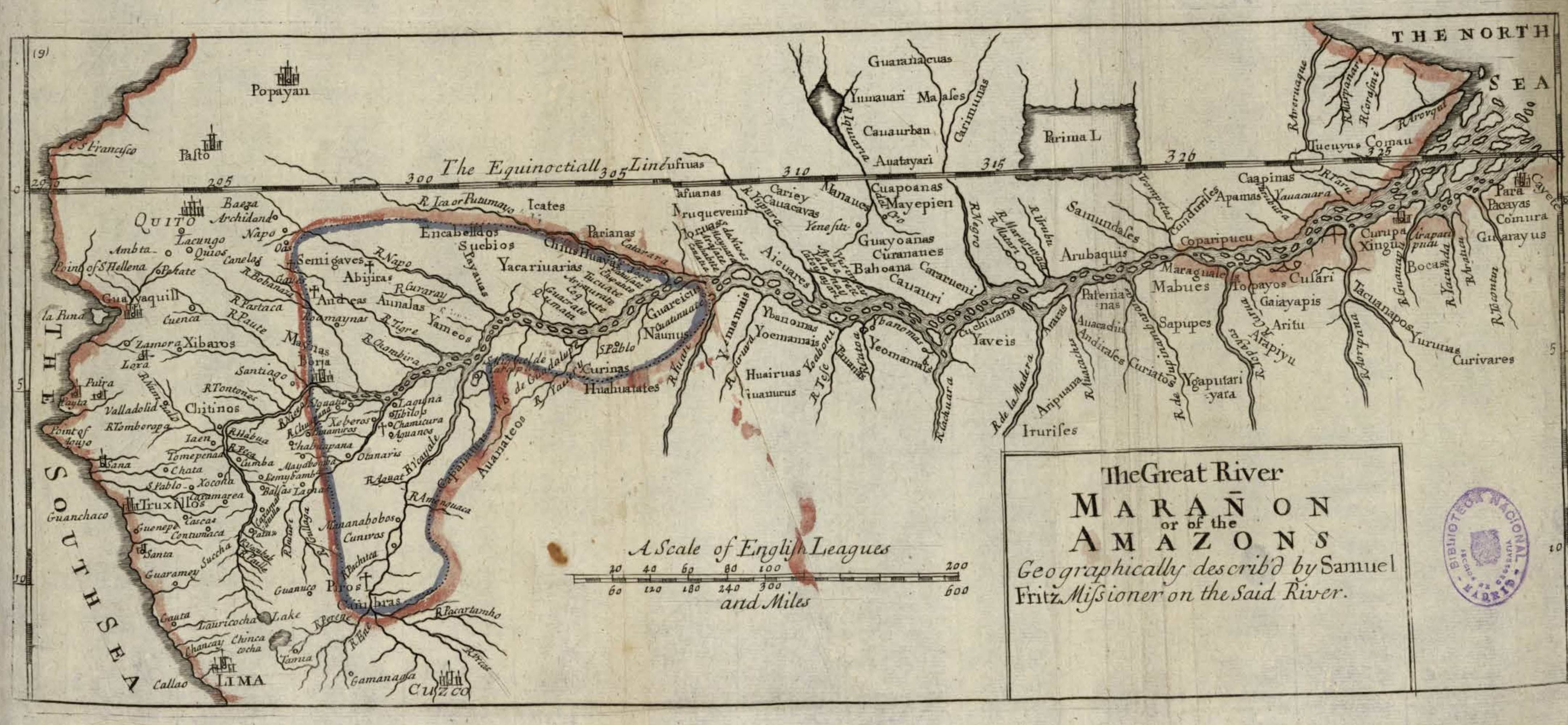
Map 1717

The Great River Marañon or of the Amazons

  • FRITZ, SAMUEL

Published: 1717

  • Download Image

Peoples

  • GUARANACUAS
  • TUMAUARI
  • MAASES
  • CAUAURBAN
  • AUATAYARI
  • CARIMUNAS
  • TUCUYUS
  • COMAU
  • GUAYARUS
  • COMURA
  • PACAYAS
  • CURIVARES
  • YURUNAS
  • BOCAS
  • XINGU
  • TACUANAPOS
  • CUSARI
  • TOPAYOS
  • GAIAYAPIS
  • ARITU
  • ARAPIYU
  • MARAGUALES
  • MABUES
  • SAPUPES
  • YGAPUTARIYARA
  • PATENIANAS
  • AUACADUS
  • ANDIRASES
  • ARARAS
  • ARIPUANA
  • IRURISES
  • YAVEIS
  • CUCHIUARAS
  • YEOMAMAIS
  • PAUANAS
  • YBANOMAS
  • YOEMAMAIS
  • HUAIRUAS
  • IUANURUS
  • YEMAMAIS
  • HUAHUATATES
  • AUANATEOS
  • CAAPINAS
  • APAMAS
  • COPARIPUCU
  • CUNDURISES
  • SAMUNDASES
  • ARUBAQUIS
  • CUAPOANAS
  • MAYEPIEN
  • GUAYOANAS
  • CURANATIES
  • BAHOANA
  • CARARUENI
  • CAUAURI
  • MANAUES
  • CARIEY
  • CAUACAVAS
  • AICUARES
  • MORUAS
  • CASUANAS
  • PARIANAS
  • ICATES
  • GUAREICUS
  • NAUNUS
  • CURINAS
  • YACARIUARIAS
  • CHIUS
  • HUAYAS
  • SUCBIOS
  • ENCABELLDOS
  • PAYAUAS
  • SEMIGAVES
  • ABIJIRAS
  • ANDEAS
  • AUNALAS
  • YAMEOS
  • MAYNAS
  • CAPANATUAS
  • CAMBRAS
  • PIROS
  • CHITINOS

Citation

Fritz, Samuel. "The Great River Marañon or of the Amazons." Map. In America, by Herman Moll, 389. Vol. 5 of Atlas Geographus or, a compleat System of Geography, ancient and modern. London: John Nutt, 1717. Accessed July 14, 2023. http://bdh.bne.es/bnesearch/detalle/bdh0000163462.
  • Download Image

Reading in Spanish

Map 1717

The Great River Marañon or of the Amazons

  • FRITZ, SAMUEL

Published: 1717

  • Download Image
  • Download Image

Related Content

Territorios con Ocupación Actual, Tradicional y Pública Ley 26.160

Territorios con Ocupación Actual, Tradicional y Pública Ley 26.160

Map 2023
A MAP of the CARACAS

A MAP of the CARACAS

Map 1818
Carte de la Guïane françoise ou du gouvernement de Caïenne depuis le Cap de Nord jusqu'àla rivière de Maroni inclusivement.

Carte de la Guïane françoise ou du gouvernement de Caïenne depuis le Cap de Nord jusqu'àla rivière de Maroni inclusivement.

Map 1729
San Vicente

San Vicente

Map 1997
FAMILIAS LINGUÍSTICAS Y LENGUAS INDÍGENAS EN OASISAMÉRICA

FAMILIAS LINGUÍSTICAS Y LENGUAS INDÍGENAS EN OASISAMÉRICA

Map 2009
Area of Tarascan Speech around 1800

Area of Tarascan Speech around 1800

Map 1800
PARTIE DE LA COLOMBIE

PARTIE DE LA COLOMBIE

Map 1827
PROVINCIA DE SANTA CRUZ

PROVINCIA DE SANTA CRUZ

Map 1873

Dispossessions in the Americas

A project by

University of Pennsylvania

Copyright 2024

With support from

Mellon Foundation

Site design & development

Element 84

Art Credits

Fritz, Samuel. “The Great River Marañon or of the Amazons.” Map. In America, by Herman Moll, 389. Vol. 5 of Atlas Geographus or, a compleat System of Geography, ancient and modern. London: John Nutt, 1717. Accessed July 14, 2023. http://bdh.bne.es/bnesearch/detalle/bdh0000163462.
Site Pages

  • Home
  • Explore
  • About
  • Authors
  • Art
  • Bodies
  • Curricula
  • Cultural Heritage
  • Maps
  • Territories