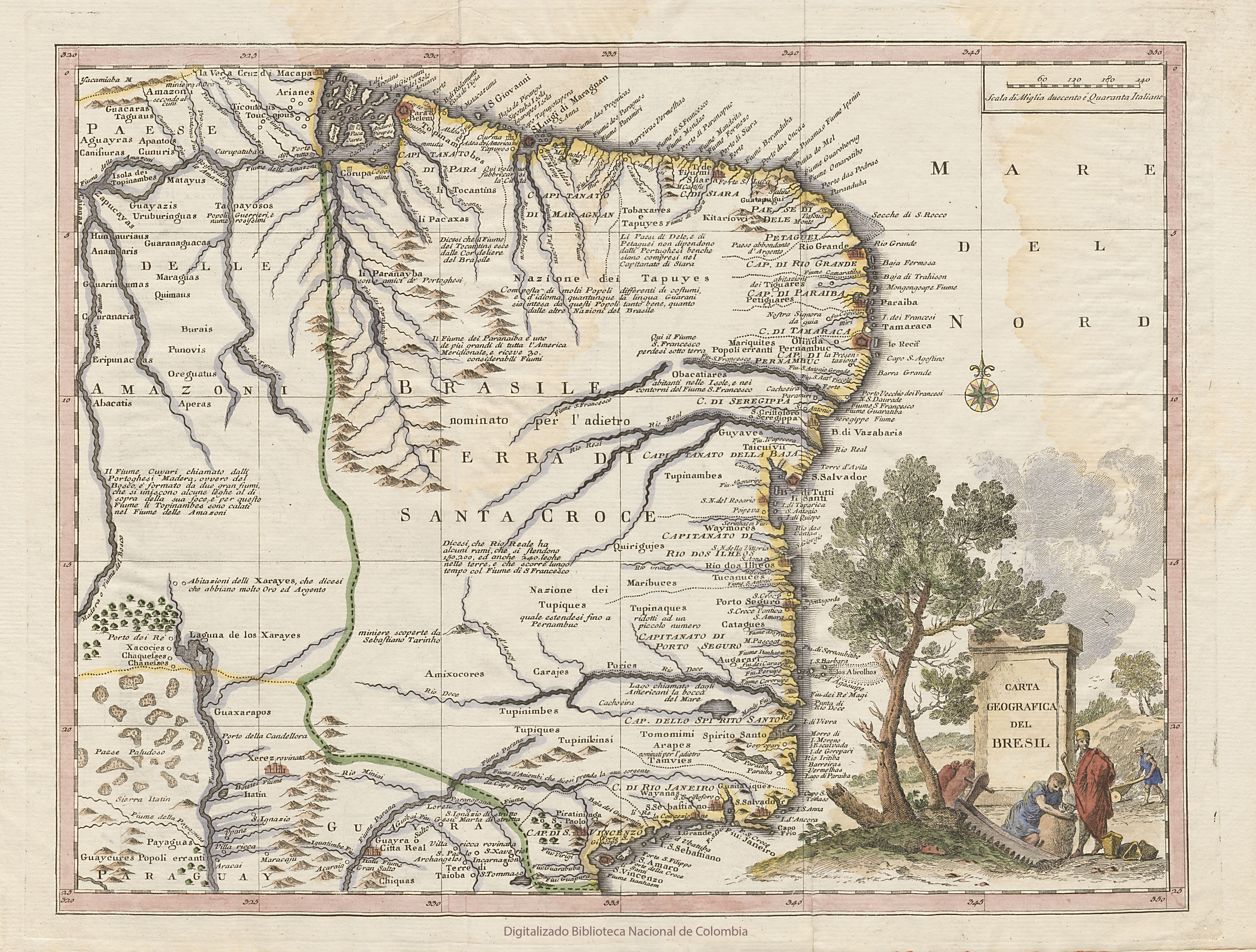
Dispossesions in the Americas

Dispossesions in the Americas

  • Home
  • Explore
  • About
  • Authors
  • Art
  • Bodies
  • Curricula
  • Cultural Heritage
  • Maps
  • Territories
Back to Explore
Map 1740

CARTA GEOGRAFICA DEL BRESIL

  • ALBRIZZI, GIOVANNI BATTISTA

Published: 1740

  • Download Image

Peoples

  • AMAZONI
  • GUACARAS
  • TAGUAUS
  • AGUAYRAS
  • CANISIURAS
  • APANTOS
  • CUNURIS
  • MATAYUS
  • GUAYAZIS
  • ZAPUCAYAS
  • URUBURINGUAS
  • TAPAYOSOS
  • TICOUTOUS
  • TOUCOJOUS
  • ARIANES
  • TOPINAMBES
  • TOBAXANES
  • TAPUYES
  • KITARIOWI
  • PETIGUARES
  • TIGUARES
  • MARIQUITES
  • POPOLI ERRANTI
  • OBACATIARES
  • GUARANAGUACAS
  • MARAGUAS
  • QUIMAUS
  • BURAIS
  • PUNOVIS
  • OREGUATUS
  • HUNNURIAUS
  • ANAMARIS
  • GUARINUMAS
  • CURANARIS
  • ERIPUNACAS
  • ABACATIS
  • APERAS
  • QUIRIGUJES
  • GUYAVES
  • TAICUIVII
  • TUPINAMBES
  • WAYMORES
  • MARIBUCES
  • TUPINAQUES
  • PORIES
  • TUCANUCES
  • CATAGUES
  • AUGARARI
  • TUPIQUES
  • CARAJES
  • TUPINIMBES
  • AMIXOCORES
  • GUAXARAPOS
  • XACOCIES
  • CHAQUESSES
  • CHANESSES
  • PAYAGUAS
  • GUAYCURES
  • CHIQUAS
  • TUPIQUES
  • TUPINIKINSI
  • TOMOMIMI
  • ARAPES
  • TAMVIES
  • WAYANAS
  • GUAITAIQUES

Citation

Albrizzi, Giovanni Battista. Carta Geografica del Bresil. Map. Venice, 1740. Accessed July 5, 2023. https://catalogoenlinea.bibliotecanacional.gov.co/custom/web/content/mapoteca/fmapoteca_47_ftsalbin_14/fmapoteca_47_ftsalbin_14.html.

  • Download Image

Reading in Spanish

Map 1740

CARTA GEOGRAFICA DEL BRESIL

  • ALBRIZZI, GIOVANNI BATTISTA

Published: 1740

  • Download Image
  • Download Image

Related Content

Nova et Accurate BRASILIAE totius TABULA

Nova et Accurate BRASILIAE totius TABULA

Map 1700 - 1745
Departamentos y municipios de mayor concentración del pueblo Awá

Departamentos y municipios de mayor concentración del pueblo Awá

Map 2005
What did they actually see?
“Out of control” Pag-127 / “Deviant” Pag-128 / “Possessed” Pag-129 2018

What did they actually see? “Out of control” Pag-127 / “Deviant” Pag-128 / “Possessed” Pag-129 2018

Artwork
Guaraní en Argentina 2016, Pueblos Guaraníes en América del Sur 2016

Guaraní en Argentina 2016, Pueblos Guaraníes en América del Sur 2016

Map 2016
Le Cours de la Riviere des Amazones

Le Cours de la Riviere des Amazones

Map 1680
San Felipe

San Felipe

Map 1997
La Guyane française : Ses limited de 1814, d'après la carte de Leblond.

La Guyane française : Ses limited de 1814, d'après la carte de Leblond.

Map 1814
Lengua wichí. Dónde se habla

Lengua wichí. Dónde se habla

Map 2009

Dispossessions in the Americas

A project by

University of Pennsylvania

Copyright 2024

With support from

Mellon Foundation

Site design & development

Element 84

Art Credits

Albrizzi, Giovanni Battista. Carta Geografica del Bresil. Map. Venice, 1740. Accessed July 5, 2023. https://catalogoenlinea.bibliotecanacional.gov.co/custom/web/content/mapoteca/fmapoteca_47_ftsalbin_14/fmapoteca_47_ftsalbin_14.html.

Site Pages

  • Home
  • Explore
  • About
  • Authors
  • Art
  • Bodies
  • Curricula
  • Cultural Heritage
  • Maps
  • Territories