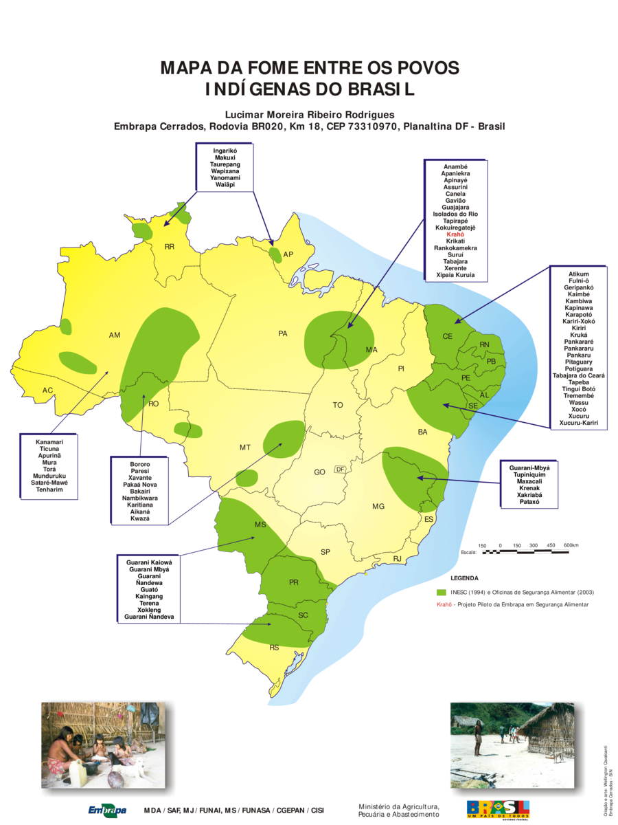
Dispossesions in the Americas

Dispossesions in the Americas

  • Home
  • Explore
  • About
  • Authors
  • Art
  • Bodies
  • Curricula
  • Cultural Heritage
  • Maps
  • Territories
Back to Explore
Map 1994 - 2003

MAPA DE FOME ENTRE OS POVOS INDIGENAS DO BRASIL

  • MOREIRA RIBEIRO RODRIGUES, LUCIMAR

Published: 2009

  • Download Image

Peoples

  • INGARIKO
  • MAKUXI
  • TAUREPANG
  • WAPIXANA
  • YANOMAMI
  • WAIAPI
  • ANAMBE
  • APANIEKRA
  • APINAYE
  • ASSURINI
  • CANELA
  • GAVIAO
  • GUAJAJARA
  • ISOLADOS DO RIO TAPIRAPE
  • KOKUIREGATEJE
  • KRAHO
  • KRIKATI
  • RANKOKAMEKRA
  • SURUI
  • TABAJARA
  • XERENTE
  • XIPAIA KURUIA
  • ATIKUM
  • FULNI-O
  • GERIPANKO
  • KAIMBE
  • KAMBIWA
  • KAPINAWA
  • KARAPOTO
  • KARIRI-XOKO
  • KIRIRI
  • KRUKA
  • PANKARARE
  • PANKARARU
  • PANKARU
  • PITAGUARY
  • POTIGUARA
  • TABAJARA DO CEARA
  • TAPEBA
  • TINGUI BOTO
  • TREMEMBE
  • WASSU
  • XOCO
  • XUCURU
  • XUCURU-KARIRI
  • GUARANI-MBYA
  • TUPINIQUIM
  • MAXACALI
  • KRENAK
  • XAKRIABA
  • PATAXO
  • GUARANI KAIOWA
  • GUARANI MBYA
  • GUARANI
  • NANDEWA
  • GUATO
  • KAINGANG
  • TERENA
  • XOKLENG
  • GUARANI NANDEVA
  • BORORO
  • PARESI
  • XAVANTE
  • PAKAA NOVA
  • BAKAIRI
  • NAMBIKWARA
  • KARITIANA
  • AIKANA
  • KWAZA
  • KANAMARI
  • TICUNA
  • APURINA
  • MURA
  • TORA
  • MUNDURUKU
  • SATARE-MAWE
  • TENHARIM

Citation

Moreira Ribeiro Rodrigues, Lucimar. "Mapa de Fome entre os Povos Indígenas do Brasil." Map. Empresa Brasileira de Pesquisa Agropecuária. 2009. Accessed July 4, 2023. https://ainfo.cnptia.embrapa.br/digital/bitstream/CPAC-2009/25355/1/p2004_43.pdf.

  • Download Image

Reading in Spanish

Map 1994 - 2003

MAPA DE FOME ENTRE OS POVOS INDIGENAS DO BRASIL

  • MOREIRA RIBEIRO RODRIGUES, LUCIMAR

Published: 2009

  • Download Image
  • Download Image

Related Content

Mapa de la Peninsula Goagira

Mapa de la Peninsula Goagira

Map 1762
Carte du gouvernement de lisle et terre ferme de Caienne France equinoxial.

Carte du gouvernement de lisle et terre ferme de Caienne France equinoxial.

Map 1724
Santa Teresa

Santa Teresa

Map 1997
Plano del pueblo de Mariguitar y de las tierras repartidas a los indios

Plano del pueblo de Mariguitar y de las tierras repartidas a los indios

Map 1703
Mexico at the time of the conquest (1519), showing the extent of the Culhua Mexica (Aztec Empire) and of the Maya holdings

Mexico at the time of the conquest (1519), showing the extent of the Culhua Mexica (Aztec Empire) and of the Maya holdings

Map 1519
The Tribes of Southern South America;at the first European contact period

The Tribes of Southern South America;at the first European contact period

Map 1512
PUEBLO TLAPANECO

PUEBLO TLAPANECO

Map 2020
GEOGRAPHISCH-STATISTISCHE UND HISTORISCHE CHARTE VON COLUMBIA

GEOGRAPHISCH-STATISTISCHE UND HISTORISCHE CHARTE VON COLUMBIA

Map 1824

Dispossessions in the Americas

A project by

University of Pennsylvania

Copyright 2024

With support from

Mellon Foundation

Site design & development

Element 84

Art Credits

Moreira Ribeiro Rodrigues, Lucimar. “Mapa de Fome entre os Povos IndĂ­genas do Brasil.” Map. Empresa Brasileira de Pesquisa Agropecuária. 2009. Accessed July 4, 2023. https://ainfo.cnptia.embrapa.br/digital/bitstream/CPAC-2009/25355/1/p2004_43.pdf.

Site Pages

  • Home
  • Explore
  • About
  • Authors
  • Art
  • Bodies
  • Curricula
  • Cultural Heritage
  • Maps
  • Territories