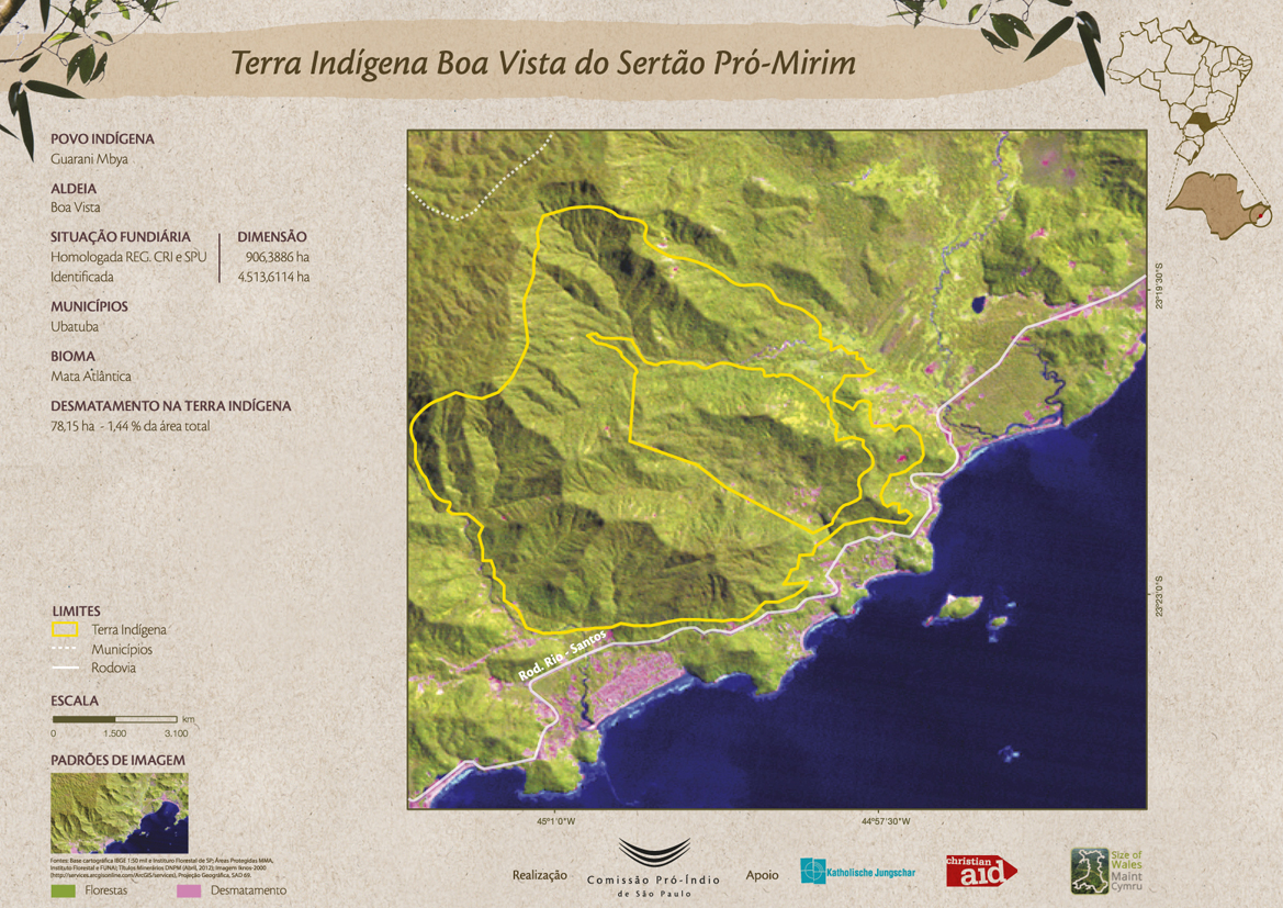
Dispossesions in the Americas

Dispossesions in the Americas

  • Home
  • Explore
  • About
  • Authors
  • Art
  • Bodies
  • Curricula
  • Cultural Heritage
  • Maps
  • Territories
Back to Explore
Map 2012

Terra Indígena Boa Vista do Sertão Pró-Mirim

  • COMISSAO PRO-INDIO DE SAO PAULO

Published: 2016

  • Download Image

Peoples

  • GUARANI MBYA

Citation

Comissão Pró-Índio de São Paulo. "Terra Indígena Boa Vista do Sertão Pró-Mirim." Map. Comissão Pró-Índio de São Paulo. September 2016. Accessed July 3, 2023. https://cpisp.org.br/wp-content/uploads/2016/09/TI_BoaVista.jpg.

  • Download Image

Reading in Spanish

Map 2012

Terra Indígena Boa Vista do Sertão Pró-Mirim

  • COMISSAO PRO-INDIO DE SAO PAULO

Published: 2016

  • Download Image
  • Download Image

Reading in Portuguese

Map 2012

Terra Indígena Boa Vista do Sertão Pró-Mirim

  • COMISSAO PRO-INDIO DE SAO PAULO

Published: 2016

  • Download Image

Peoples

  • GUARANI MBYA

Citation

Comissão Pró-Índio de São Paulo. "Terra Indígena Boa Vista do Sertão Pró-Mirim." Map. Comissão Pró-Índio de São Paulo. September 2016. Accessed July 3, 2023. https://cpisp.org.br/wp-content/uploads/2016/09/TI_BoaVista.jpg.

  • Download Image

Related Content

PUEBLO YAGUA

PUEBLO YAGUA

Map 2021
PUEBLO DE TETELA, PERTENECIENTE A LA CORONA, EN EL DISTRITO DE LA AUDIENCIA DE MÉXICO

PUEBLO DE TETELA, PERTENECIENTE A LA CORONA, EN EL DISTRITO DE LA AUDIENCIA DE MÉXICO

Map 1581
A Map of part of Yucatan or of that Part of the Eastern Shore Within the Bay of Honduras Alloted to Great Britain for the Cutting of Logwood, in consequence of the Convention Signed with Spain on the 14th July 1786.

A Map of part of Yucatan or of that Part of the Eastern Shore Within the Bay of Honduras Alloted to Great Britain for the Cutting of Logwood, in consequence of the Convention Signed with Spain on the 14th July 1786.

Map 1700
Fig. 1 Map of the Guianas with schematic locations of the
indigenous groups relevant to our study, based on the linguistic
map of South America (http://www.muturzikin.com/cartesamerique/
7.htm). Carib-speaking groups are indicated in yellow, Arawak-speaking
groups in blue, Tupi-speaking Wayãpi in pink and the Warao-speaking
group in green

Fig. 1 Map of the Guianas with schematic locations of the indigenous groups relevant to our study, based on the linguistic map of South America (http://www.muturzikin.com/cartesamerique/ 7.htm). Carib-speaking groups are indicated in yellow, Arawak-speaking groups in blue, Tupi-speaking Wayãpi in pink and the Warao-speaking group in green

Map 2000 - 2024
El mapa de los pueblos indígenas de Bolivia

El mapa de los pueblos indígenas de Bolivia

Map 2007
Map of El Salvador with Specific indigenous communities in El Salvador, and the archaeological zone of Chalchuapa in western El Salvador. The Department of San Vicente is also highlighted.

Map of El Salvador with Specific indigenous communities in El Salvador, and the archaeological zone of Chalchuapa in western El Salvador. The Department of San Vicente is also highlighted.

Map 2010
SOUTH AMERICA SHEET III. SOUTH BRAZIL WITH PARAGUAY AND URUGUAY

SOUTH AMERICA SHEET III. SOUTH BRAZIL WITH PARAGUAY AND URUGUAY

Map 1837
PUEBLO NAHUA DE JALISCO

PUEBLO NAHUA DE JALISCO

Map 2020

Dispossessions in the Americas

A project by

University of Pennsylvania

Copyright 2024

With support from

Mellon Foundation

Site design & development

Element 84

Art Credits

Comissão Pró-Índio de São Paulo. “Terra Indígena Boa Vista do Sertão Pró-Mirim.” Map. Comissão Pró-Índio de São Paulo. September 2016. Accessed July 3, 2023. https://cpisp.org.br/wp-content/uploads/2016/09/TI_BoaVista.jpg.

Site Pages

  • Home
  • Explore
  • About
  • Authors
  • Art
  • Bodies
  • Curricula
  • Cultural Heritage
  • Maps
  • Territories