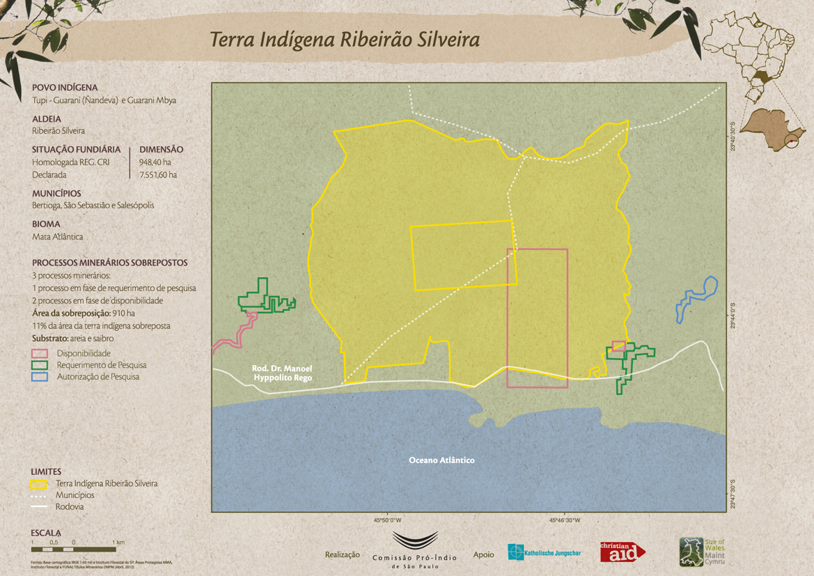
Dispossesions in the Americas

Dispossesions in the Americas

  • Home
  • Explore
  • About
  • Authors
  • Art
  • Bodies
  • Curricula
  • Cultural Heritage
  • Maps
  • Territories
Back to Explore
Map 2012

Terra Indígena Ribeirão Silveira

  • COMISSAO PRO-INDIO DE SAO PAULO

Published: 2016

  • Download Image

Peoples

  • GUARANI NANDEVA
  • GUARANI MBYA

Citation

Comissão Pró-Índio de São Paulo. "Terra Indígena Ribeirão Silveira." Map. Comissão Pró-Índio de São Paulo. September 2016. Accessed July 3, 2023. https://cpisp.org.br/wp-content/uploads/2016/09/TI_RibeiraoSilveira_Mineracao.jpg.

  • Download Image

Reading in Spanish

Map 2012

Terra Indígena Ribeirão Silveira

  • COMISSAO PRO-INDIO DE SAO PAULO

Published: 2016

  • Download Image
  • Download Image

Reading in Portuguese

Map 2012

Terra Indígena Ribeirão Silveira

  • COMISSAO PRO-INDIO DE SAO PAULO

Published: 2016

  • Download Image

Peoples

  • GUARANI NANDEVA
  • GUARANI MBYA

Citation

Comissão Pró-Índio de São Paulo. "Terra Indígena Ribeirão Silveira." Map. Comissão Pró-Índio de São Paulo. September 2016. Accessed July 3, 2023. https://cpisp.org.br/wp-content/uploads/2016/09/TI_RibeiraoSilveira_Mineracao.jpg.

  • Download Image

Related Content

Mapa por despacho de Vice-ministerios

Mapa por despacho de Vice-ministerios

Map 2012
Conozca Loreto [Discover Loreto]

Conozca Loreto [Discover Loreto]

Artwork
Carte particulière de l'Isle et des environs de Cayenne colonie françoise À Paris Chez Desnos, Ingénieur pour les Globes et Sphères.

Carte particulière de l'Isle et des environs de Cayenne colonie françoise À Paris Chez Desnos, Ingénieur pour les Globes et Sphères.

Map 1700 - 1799
Serie Fatherland / Padre Patria

Serie Fatherland / Padre Patria

Artwork
No Title

No Title

Map 1720
The Spanish and Musketor shore and the bay of Honduras and the islands adjacent

The Spanish and Musketor shore and the bay of Honduras and the islands adjacent

Map 1735
Demostración de las Provincias interiores del Perú, que componen parte del Virreynato de Buenos Ayres

Demostración de las Provincias interiores del Perú, que componen parte del Virreynato de Buenos Ayres

Map 1776
Terre de Sainte Croix, nommée apresent Bresil

Terre de Sainte Croix, nommée apresent Bresil

Map 1749

Dispossessions in the Americas

A project by

University of Pennsylvania

Copyright 2024

With support from

Mellon Foundation

Site design & development

Element 84

Art Credits

Comissão Pró-Índio de São Paulo. “Terra Indígena Ribeirão Silveira.” Map. Comissão Pró-Índio de São Paulo. September 2016. Accessed July 3, 2023. https://cpisp.org.br/wp-content/uploads/2016/09/TI_RibeiraoSilveira_Mineracao.jpg.

Site Pages

  • Home
  • Explore
  • About
  • Authors
  • Art
  • Bodies
  • Curricula
  • Cultural Heritage
  • Maps
  • Territories