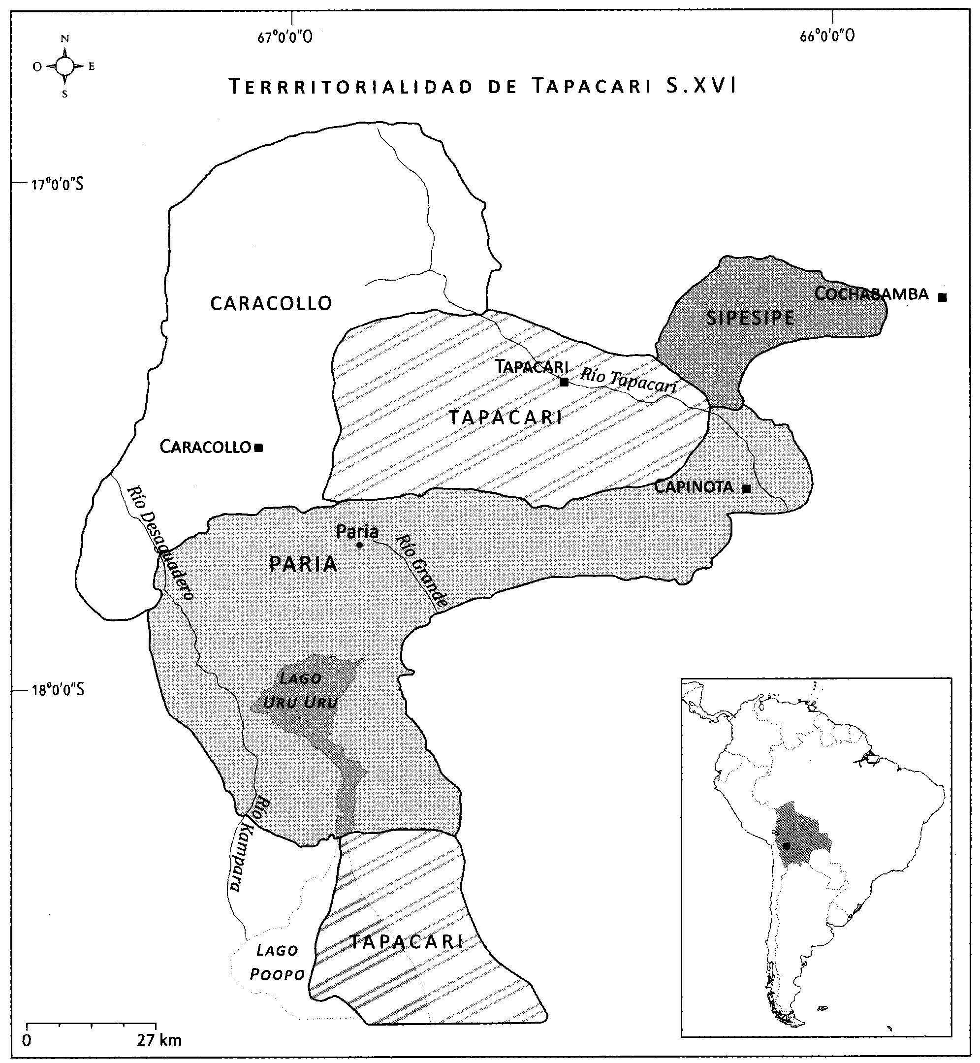
Dispossesions in the Americas

Dispossesions in the Americas

  • Home
  • Explore
  • About
  • Authors
  • Art
  • Bodies
  • Curricula
  • Cultural Heritage
  • Maps
  • Territories
Back to Explore
Map 1500 - 1599

EL SEÑORÍO AYMARA DE LOS SURAS: COLONIAS DE SURA BAJO EL DOMINIO INCA EN EL SIGLO XVI

  • Del Río, M.

Published: 2018

  • Download Image

Peoples

  • SORA (TAPACARI)

Citation

Del Rio, M. (2018). Dinastías señoriales y transformaciones territoriales entre los Sura de Tapacarí S. XVI-XVII. En M. de L.A. Muñoz Collazos (Ed.), Interpretando huellas. arqueología, etnohistoria y etnografía de los andes y sus tierras bajas (pp. 391-408). Kipus.

  • Download Image

Reading in Spanish

Map 1500 - 1599

EL SEÑORÍO AYMARA DE LOS SURAS: COLONIAS DE SURA BAJO EL DOMINIO INCA EN EL SIGLO XVI

  • Del Río, M.

Published: 2018

  • Download Image
  • Download Image

Reading in Portuguese

Map 1500 - 1599

EL SEÑORÍO AYMARA DE LOS SURAS: COLONIAS DE SURA BAJO EL DOMINIO INCA EN EL SIGLO XVI

  • Del Río, M.

Published: 2018

  • Download Image

Peoples

  • SORA (TAPACARI)

Citation

Del Rio, M. (2018). Dinastías señoriales y transformaciones territoriales entre los Sura de Tapacarí S. XVI-XVII. En M. de L.A. Muñoz Collazos (Ed.), Interpretando huellas. arqueología, etnohistoria y etnografía de los andes y sus tierras bajas (pp. 391-408). Kipus.

  • Download Image

Related Content

San Juan Baptista, San Luys Tezontla y Santa María Nochtongo. Oaxaca, 1579

San Juan Baptista, San Luys Tezontla y Santa María Nochtongo. Oaxaca, 1579

Map 1579
Map of Mapuche Land Dispossession for Chilean and German Settlers

Map of Mapuche Land Dispossession for Chilean and German Settlers

Map 1911 - 1952
BRAZIL

BRAZIL

Map 1895
Territorios indígenas de Guatemala antes de 1524

Territorios indígenas de Guatemala antes de 1524

Map 1523
SOUTH AMERICA FROM THE BEST AUTHORITIES

SOUTH AMERICA FROM THE BEST AUTHORITIES

Map 1802
IDIOMAS DE GUATEMALA Y BELICE

IDIOMAS DE GUATEMALA Y BELICE

Map
PLAN DE L'ENTREE DE LA RIVIERE DE CONNANI dans la coste des maÿée province de guiàne

PLAN DE L'ENTREE DE LA RIVIERE DE CONNANI dans la coste des maÿée province de guiàne

Map 1755
Comunidades indígenas del Paraguay

Comunidades indígenas del Paraguay

Map 2001

Dispossessions in the Americas

A project by

University of Pennsylvania

Copyright 2024

With support from

Mellon Foundation

Site design & development

Element 84

Art Credits

Del Rio, M. (2018). Dinastías señoriales y transformaciones territoriales entre los Sura de Tapacarí S. XVI-XVII. En M. de L.A. Muñoz Collazos (Ed.), Interpretando huellas. arqueología, etnohistoria y etnografía de los andes y sus tierras bajas (pp. 391-408). Kipus.

Site Pages

  • Home
  • Explore
  • About
  • Authors
  • Art
  • Bodies
  • Curricula
  • Cultural Heritage
  • Maps
  • Territories