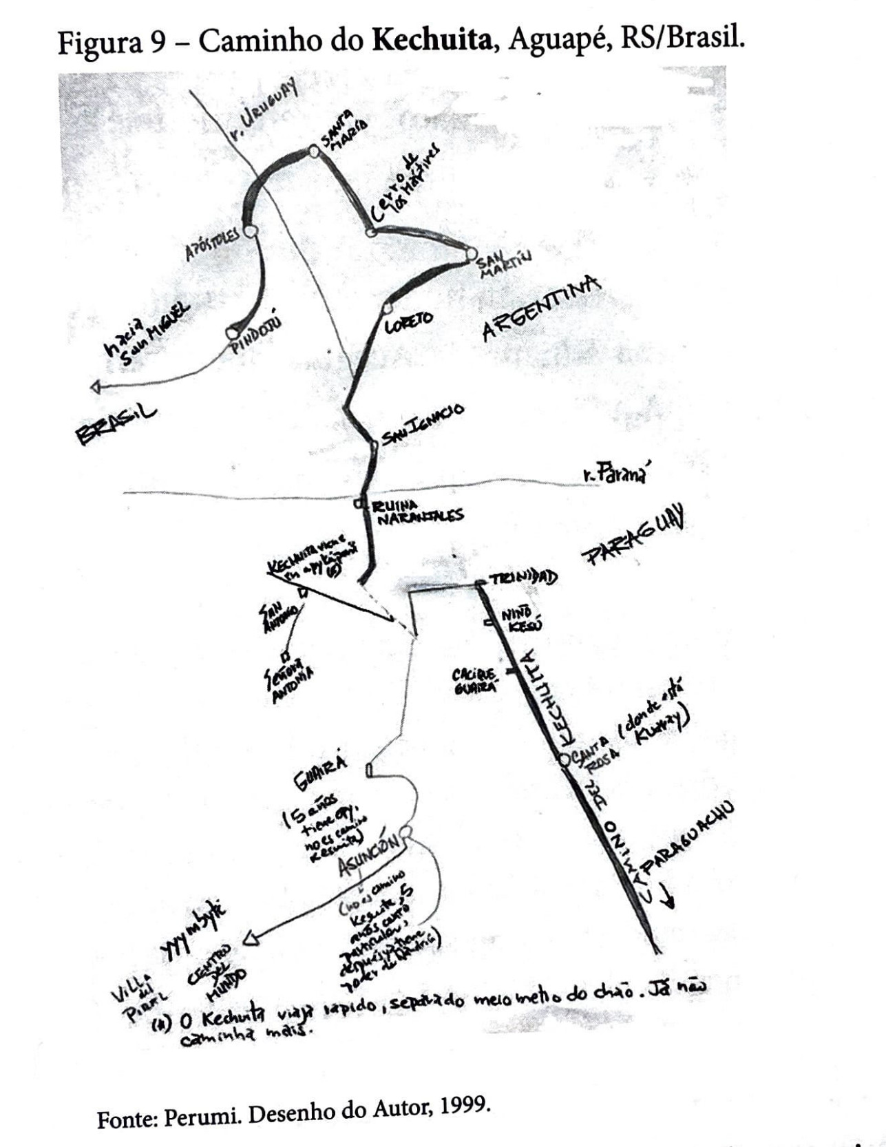
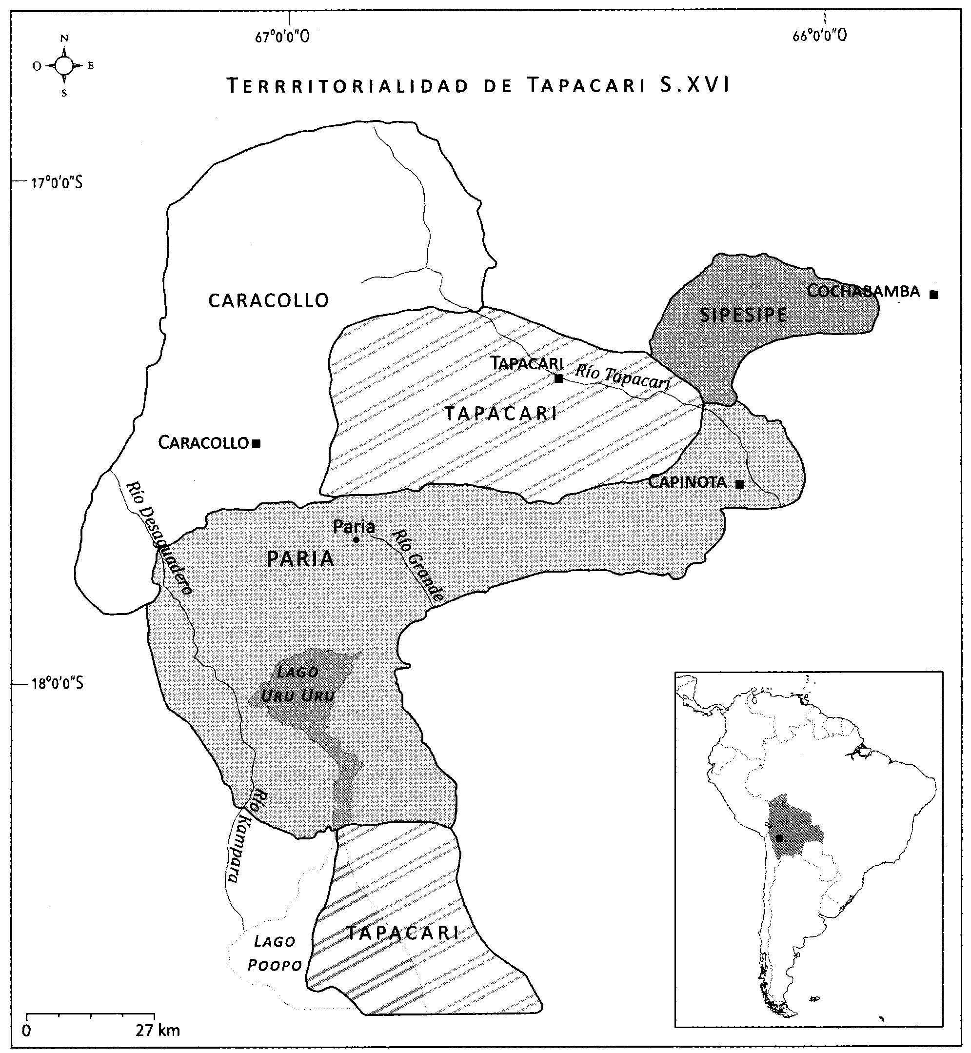
Dispossesions in the Americas

Dispossesions in the Americas

  • Home
  • Explore
  • About
  • Authors
  • Art
  • Bodies
  • Curricula
  • Cultural Heritage
  • Maps
  • Territories
Back to Explore
Map 1500 - 1599

EL SEÑORÍO AYMARA DE LOS SURAS: COLONIAS DE SURA BAJO EL DOMINIO INCA EN EL SIGLO XVI

  • Del Río, M.

Published: 2018

  • Download Image

Peoples

  • SORA (TAPACARI)

Citation

Del Rio, M. (2018). Dinastías señoriales y transformaciones territoriales entre los Sura de Tapacarí S. XVI-XVII. En M. de L.A. Muñoz Collazos (Ed.), Interpretando huellas. arqueología, etnohistoria y etnografía de los andes y sus tierras bajas (pp. 391-408). Kipus.

  • Download Image

Reading in Spanish

Map 1500 - 1599

EL SEÑORÍO AYMARA DE LOS SURAS: COLONIAS DE SURA BAJO EL DOMINIO INCA EN EL SIGLO XVI

  • Del Río, M.

Published: 2018

  • Download Image
  • Download Image

Reading in Portuguese

Map 1500 - 1599

EL SEÑORÍO AYMARA DE LOS SURAS: COLONIAS DE SURA BAJO EL DOMINIO INCA EN EL SIGLO XVI

  • Del Río, M.

Published: 2018

  • Download Image

Peoples

  • SORA (TAPACARI)

Citation

Del Rio, M. (2018). Dinastías señoriales y transformaciones territoriales entre los Sura de Tapacarí S. XVI-XVII. En M. de L.A. Muñoz Collazos (Ed.), Interpretando huellas. arqueología, etnohistoria y etnografía de los andes y sus tierras bajas (pp. 391-408). Kipus.

  • Download Image

Related Content

Carta Del Gran Chaco e Paesi Confinanti

Carta Del Gran Chaco e Paesi Confinanti

Map 1700 - 1767
Indigenous groups and Miskitu settlements in eastern Nicaragua.

Indigenous groups and Miskitu settlements in eastern Nicaragua.

Map 1990
A New Map of the Southern Parts of America

A New Map of the Southern Parts of America

Map 1772
The Aboriginal Distribution of Tribes in Northwest Mexico

The Aboriginal Distribution of Tribes in Northwest Mexico

Map 1969
Angaité

Angaité

Map 2001
El manifiesto PrEP [The PrEP Manifesto]

El manifiesto PrEP [The PrEP Manifesto]

Artwork
Caminho do Kechuita, Aguapé, RS/Brasil

Caminho do Kechuita, Aguapé, RS/Brasil

Map 1999
PUEBLO TLAPANECO

PUEBLO TLAPANECO

Map 2020

Dispossessions in the Americas

A project by

University of Pennsylvania

Copyright 2024

With support from

Mellon Foundation

Site design & development

Element 84

Art Credits

Del Rio, M. (2018). Dinastías señoriales y transformaciones territoriales entre los Sura de Tapacarí S. XVI-XVII. En M. de L.A. Muñoz Collazos (Ed.), Interpretando huellas. arqueología, etnohistoria y etnografía de los andes y sus tierras bajas (pp. 391-408). Kipus.

Site Pages

  • Home
  • Explore
  • About
  • Authors
  • Art
  • Bodies
  • Curricula
  • Cultural Heritage
  • Maps
  • Territories