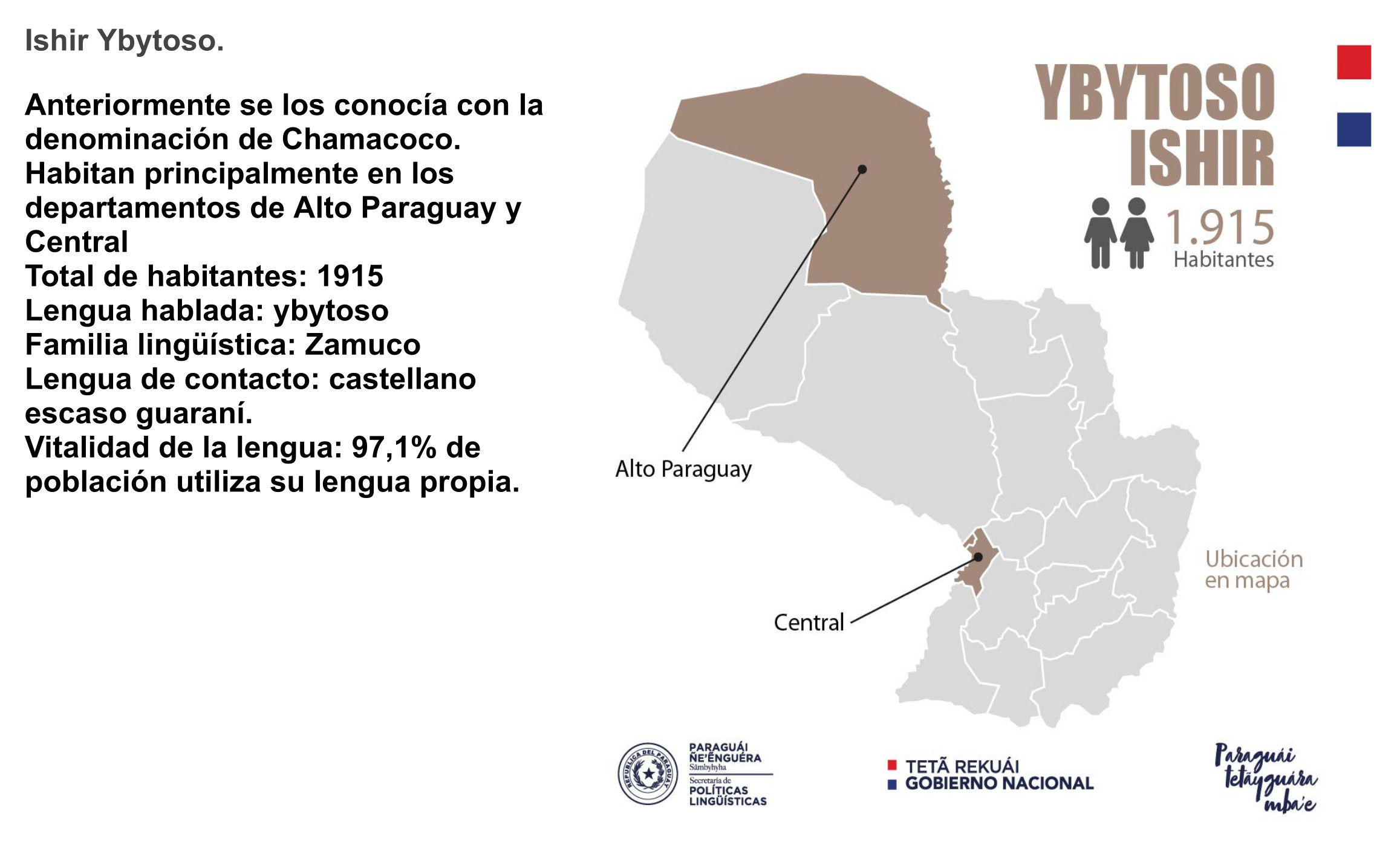
Dispossesions in the Americas

Dispossesions in the Americas

  • Home
  • Explore
  • About
  • Authors
  • Art
  • Bodies
  • Curricula
  • Cultural Heritage
  • Maps
  • Territories
Back to Explore
Map 2010

Mapa de Ubicacion de Grupos y Pueblos Indigenas en Aislamiento Voluntario

  • Monras, Jorge

Published: 2010

  • Download Image

Peoples

  • PACAHUARA
  • ESE EJA
  • ARAONA
  • TOROMONA
  • YURACARE
  • YUQUI
  • AYOREO

Citation

Nassar, Carlos Camacho. ENTRE EL ETNOCIDIO Y LA EXTINCION: Pueblos indIgenas aislados, en contacto inicial e intermitente en las tierras bajas de Bolivia, 2010. https://www.iwgia.org/images/publications/0276_Bolivia_-_Entre_El_Ethnicido_-_Informe_6.pdf

  • Download Image

Reading in Spanish

Map 2010

Mapa de Ubicacion de Grupos y Pueblos Indigenas en Aislamiento Voluntario

  • Monras, Jorge

Published: 2010

  • Download Image
  • Download Image

Reading in Portuguese

Map 2010

Mapa de Ubicacion de Grupos y Pueblos Indigenas en Aislamiento Voluntario

  • Monras, Jorge

Published: 2010

  • Download Image

Peoples

  • PACAHUARA
  • ESE EJA
  • ARAONA
  • TOROMONA
  • YURACARE
  • YUQUI
  • AYOREO

Citation

Nassar, Carlos Camacho. ENTRE EL ETNOCIDIO Y LA EXTINCION: Pueblos indIgenas aislados, en contacto inicial e intermitente en las tierras bajas de Bolivia, 2010. https://www.iwgia.org/images/publications/0276_Bolivia_-_Entre_El_Ethnicido_-_Informe_6.pdf

  • Download Image

Related Content

YBYTOSO ISHIR

YBYTOSO ISHIR

Map 2015
A New Map of Mexico and Adjacent Provinces Compiled From Original Documents

A New Map of Mexico and Adjacent Provinces Compiled From Original Documents

Map 1810
CARTA COROGRÁFICA DE JALISCO, ZACATECAS Y COLIMA

CARTA COROGRÁFICA DE JALISCO, ZACATECAS Y COLIMA

Map 1824
CARTE DU MIXTECAPAN

CARTE DU MIXTECAPAN

Map 1906
Carte de la Goÿanne Françoise depuis le fort de Barou et la Rte. d Yari jusqu'a Maroni. Les principaux établissements des François tant dans l'isle de Caÿenne que dans la Terre Ferme

Carte de la Goÿanne Françoise depuis le fort de Barou et la Rte. d Yari jusqu'a Maroni. Les principaux établissements des François tant dans l'isle de Caÿenne que dans la Terre Ferme

Map 1741
ORDENAMIENTO POLÍTICO DEL ESPACIO BAJO EL DOMINIO COLONIAL A FINALES DEL SIGLO XVI

ORDENAMIENTO POLÍTICO DEL ESPACIO BAJO EL DOMINIO COLONIAL A FINALES DEL SIGLO XVI

Map 1580
Islas Antillas y costas de tierra firme.

Islas Antillas y costas de tierra firme.

Map 1500 - 1599
TERRE FERME ou sont les governations ou gouvernemens de Terre ferme;Cartagene Ste. Marthe;Rio de la Hache;Venezuela;nouvelle Andalusie Popayein;nouveau royme de Grenade;&c

TERRE FERME ou sont les governations ou gouvernemens de Terre ferme;Cartagene Ste. Marthe;Rio de la Hache;Venezuela;nouvelle Andalusie Popayein;nouveau royme de Grenade;&c

Map 1656

Dispossessions in the Americas

A project by

University of Pennsylvania

Copyright 2024

With support from

Mellon Foundation

Site design & development

Element 84

Art Credits

Nassar, Carlos Camacho. ENTRE EL ETNOCIDIO Y LA EXTINCION: Pueblos indIgenas aislados, en contacto inicial e intermitente en las tierras bajas de Bolivia, 2010. https://www.iwgia.org/images/publications/0276_Bolivia_-_Entre_El_Ethnicido_-_Informe_6.pdf

Site Pages

  • Home
  • Explore
  • About
  • Authors
  • Art
  • Bodies
  • Curricula
  • Cultural Heritage
  • Maps
  • Territories