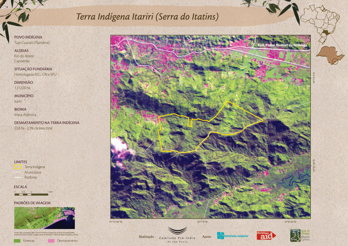
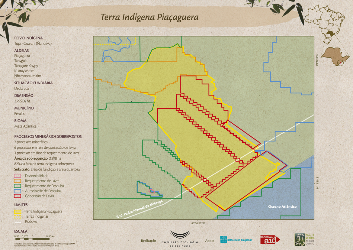
Dispossesions in the Americas

Dispossesions in the Americas

  • Home
  • Explore
  • About
  • Authors
  • Art
  • Bodies
  • Curricula
  • Cultural Heritage
  • Maps
  • Territories
Back to Explore
Map 1800

Las etnias de Tierra del Fuego antes de su extinción

  • Chapman, Anne

Published: 2002

  • Download Image

Peoples

  • SELK'NAM
  • HAUSH
  • YAMANA
  • ALAKALUFES

Citation

Chapman, Anne. End of a World: The Selknam of Tierra Del Fuego. Santiago, Chile: Taller Experimental Cuerpos Pintados, 2002, p.19 chrome-extension://efaidnbmnnnibpcajpcglclefindmkaj/https://www.memoriachilena.gob.cl/archivos2/pdfs/MC0043450.pdf

  • Download Image

Reading in Spanish

Map 1800

Las etnias de Tierra del Fuego antes de su extinción

  • Chapman, Anne

Published: 2002

  • Download Image
  • Download Image

Reading in Portuguese

Map 1800

Las etnias de Tierra del Fuego antes de su extinción

  • Chapman, Anne

Published: 2002

  • Download Image

Peoples

  • SELK'NAM
  • HAUSH
  • YAMANA
  • ALAKALUFES

Citation

Chapman, Anne. End of a World: The Selknam of Tierra Del Fuego. Santiago, Chile: Taller Experimental Cuerpos Pintados, 2002, p.19 chrome-extension://efaidnbmnnnibpcajpcglclefindmkaj/https://www.memoriachilena.gob.cl/archivos2/pdfs/MC0043450.pdf

  • Download Image

Related Content

Ixil and Q'eqchi' speaking regions of Guatemala.

Ixil and Q'eqchi' speaking regions of Guatemala.

Map 2000
Map of the RIVER AQUIRY (an Affluent of the Purûs)

Map of the RIVER AQUIRY (an Affluent of the Purûs)

Map 1800 - 1850
Carta ó Mapa Geográfico de una gran parte del Reino de N. E. [Nueva España], comprendido entre los 19 y 42 grados de latitud Septentrional y entre 249 y 289 grados de longitud del Meridiano de Tenerife, formado de orden del Exc[elentísi]mo S[eño]r B[eilí]o Fr[ey] D[o]n Ant[oni]o Maria Bucarely y Vrsúa p[ar]a indicar la division del Virreinato de México y de las Provincias internas erigidas en Comandancia General en virtud de Reales Órdenes el año 1770

Carta ó Mapa Geográfico de una gran parte del Reino de N. E. [Nueva España], comprendido entre los 19 y 42 grados de latitud Septentrional y entre 249 y 289 grados de longitud del Meridiano de Tenerife, formado de orden del Exc[elentísi]mo S[eño]r B[eilí]o Fr[ey] D[o]n Ant[oni]o Maria Bucarely y Vrsúa p[ar]a indicar la division del Virreinato de México y de las Provincias internas erigidas en Comandancia General en virtud de Reales Órdenes el año 1770

Map 1770
Terra Indígena Itariri (Serra do Itatins)

Terra Indígena Itariri (Serra do Itatins)

Map 2011
Terra Indígena Piçaguera

Terra Indígena Piçaguera

Map 2012
Carte 6: Migrations des Tupi au nord de l'Amazones (XVIe et XVIIe siècles)

Carte 6: Migrations des Tupi au nord de l'Amazones (XVIe et XVIIe siècles)

Map 1500 - 1699
Shipibas vendiendo artesanías en Lima [Shipibas Selling Handicrafts in Lima]

Shipibas vendiendo artesanías en Lima [Shipibas Selling Handicrafts in Lima]

Artwork
The Barima River as depicted on Dixon's compass traverse and the AGS million-scale map published in 1940 (bottom)

The Barima River as depicted on Dixon's compass traverse and the AGS million-scale map published in 1940 (bottom)

Map 1895

Dispossessions in the Americas

A project by

University of Pennsylvania

Copyright 2024

With support from

Mellon Foundation

Site design & development

Element 84

Art Credits

Chapman, Anne. End of a World: The Selknam of Tierra Del Fuego. Santiago, Chile: Taller Experimental Cuerpos Pintados, 2002, p.19 chrome-extension://efaidnbmnnnibpcajpcglclefindmkaj/https://www.memoriachilena.gob.cl/archivos2/pdfs/MC0043450.pdf

Site Pages

  • Home
  • Explore
  • About
  • Authors
  • Art
  • Bodies
  • Curricula
  • Cultural Heritage
  • Maps
  • Territories