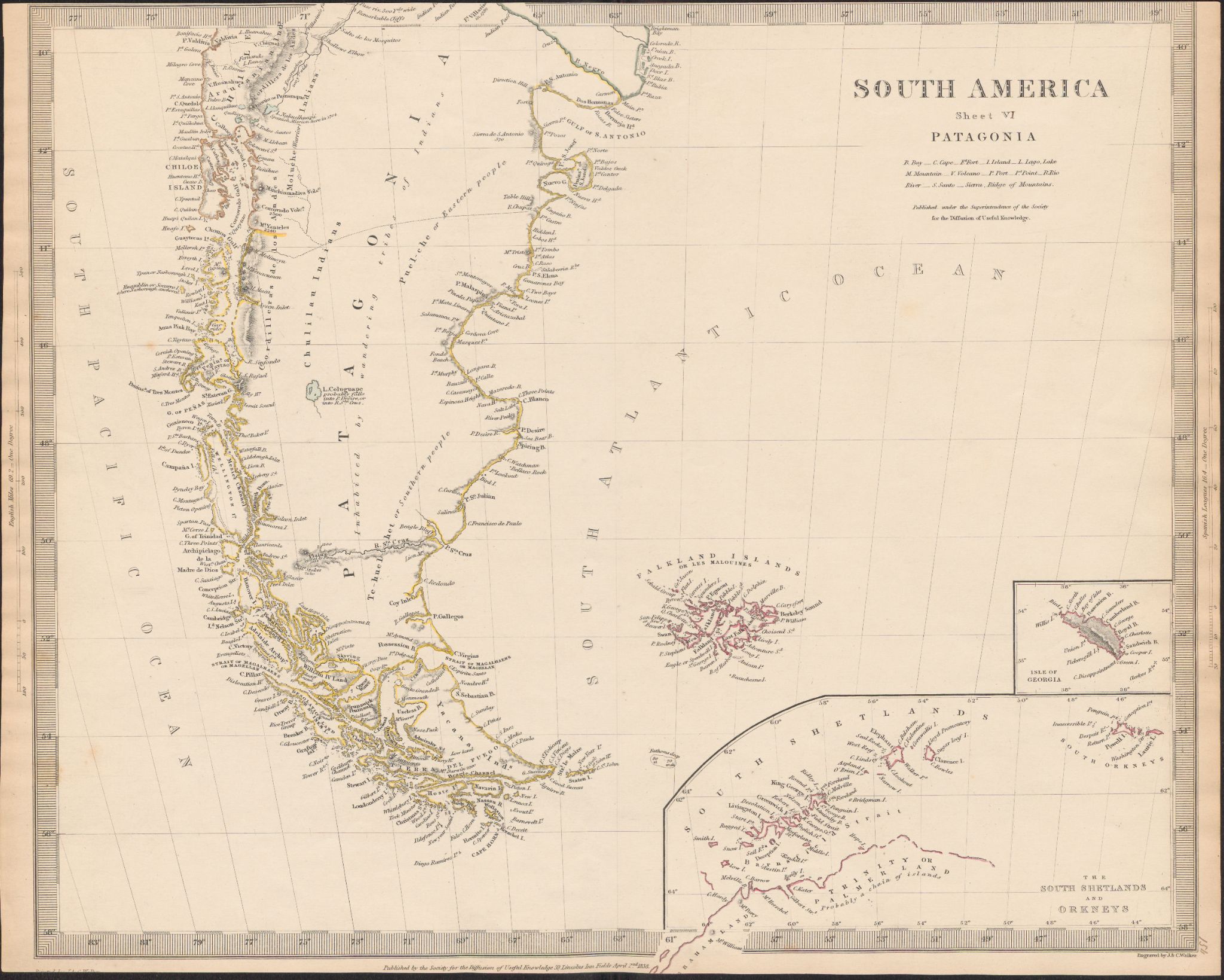
Dispossesions in the Americas

Dispossesions in the Americas

  • Home
  • Explore
  • About
  • Authors
  • Art
  • Bodies
  • Curricula
  • Cultural Heritage
  • Maps
  • Territories
Back to Explore
Map 1800 - 1850

South America

  • WALKER, JONH

Published: 1838

  • Download Image

Peoples

  • PUEL-CHE OR EASTERN PEOPLE
  • TE-HUEL-SHET OR SOUTHERN PEOPLE
  • PUELCHES
  • TEHUELCHES
  • MOLUCHE
  • ARAUCANIAN INDIANS
  • ARAUCANOS
  • MOLUCHES
  • YACANA INDIANS
  • YACANAS

Citation

Walker, Jonh. South America. Map. London, United Kingdom: Society for the Diffusion of Useful Knowledge, 1838. Accessed July 9, 2023. https://digital.iai.spk-berlin.de/viewer/image/63010896X/1/LOG_0000/.

  • Download Image

Reading in Spanish

Map 1800 - 1850

South America

  • WALKER, JONH

Published: 1838

  • Download Image
  • Download Image

Reading in Portuguese

Map 1800 - 1850

South America

  • WALKER, JONH

Published: 1838

  • Download Image

Peoples

  • PUEL-CHE OR EASTERN PEOPLE
  • TE-HUEL-SHET OR SOUTHERN PEOPLE
  • PUELCHES
  • TEHUELCHES
  • MOLUCHE
  • ARAUCANIAN INDIANS
  • ARAUCANOS
  • MOLUCHES
  • YACANA INDIANS
  • YACANAS

Citation

Walker, Jonh. South America. Map. London, United Kingdom: Society for the Diffusion of Useful Knowledge, 1838. Accessed July 9, 2023. https://digital.iai.spk-berlin.de/viewer/image/63010896X/1/LOG_0000/.

  • Download Image

Related Content

Bolivia Or Upper Peru;Chili and the United Provinces Of South America, or La Plata

Bolivia Or Upper Peru;Chili and the United Provinces Of South America, or La Plata

Map 1800 - 1850
[O ateliê], sem data [The studio, undated]

[O ateliê], sem data [The studio, undated]

Artwork
Girls with Guitars

Girls with Guitars

Artwork
Entrée des rivières d'Ouyapoco et de Couripi.

Entrée des rivières d'Ouyapoco et de Couripi.

Map 1764
PUEBLO TACUATE

PUEBLO TACUATE

Map 2020
MAPA 1. TERRITORIOS DE LOS GRUPOS HUAORANI AL TIEMPO DE CONTACTO

MAPA 1. TERRITORIOS DE LOS GRUPOS HUAORANI AL TIEMPO DE CONTACTO

Map 1958
MAPA 1. TERRITORIO WAORANI;GRUPOS TAGAERI;TAROMENANE Y BLOQUES PETROLEROS EN EL YASUNÍ

MAPA 1. TERRITORIO WAORANI;GRUPOS TAGAERI;TAROMENANE Y BLOQUES PETROLEROS EN EL YASUNÍ

Map 2013
Pintura de las tierras, pantanos y anegadizos del pueblo de Bogotá hecha por mandato de la Real Audiencia desta çiudad de Sancta Fee del Nuevo Reyno de Granada en la causa que en ella trata el señor fiscal con don Francisco Maldonado de Mendoça.

Pintura de las tierras, pantanos y anegadizos del pueblo de Bogotá hecha por mandato de la Real Audiencia desta çiudad de Sancta Fee del Nuevo Reyno de Granada en la causa que en ella trata el señor fiscal con don Francisco Maldonado de Mendoça.

Map 1614

Dispossessions in the Americas

A project by

University of Pennsylvania

Copyright 2024

With support from

Mellon Foundation

Site design & development

Element 84

Art Credits

Walker, Jonh. South America. Map. London, United Kingdom: Society for the Diffusion of Useful Knowledge, 1838. Accessed July 9, 2023. https://digital.iai.spk-berlin.de/viewer/image/63010896X/1/LOG_0000/.

Site Pages

  • Home
  • Explore
  • About
  • Authors
  • Art
  • Bodies
  • Curricula
  • Cultural Heritage
  • Maps
  • Territories