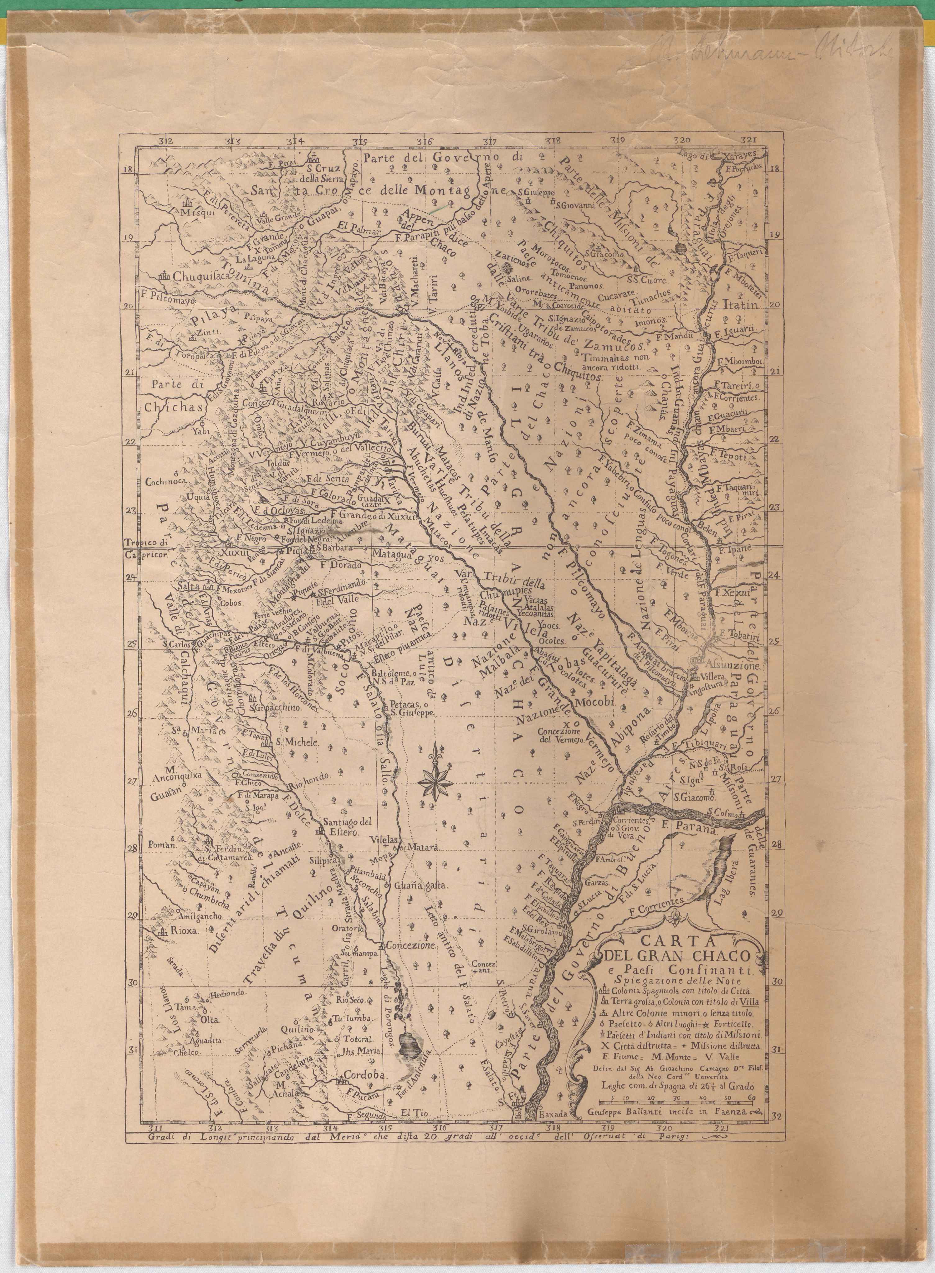
Dispossesions in the Americas

Dispossesions in the Americas

  • Home
  • Explore
  • About
  • Authors
  • Art
  • Bodies
  • Curricula
  • Cultural Heritage
  • Maps
  • Territories
Back to Explore
Map 1700 - 1767

Carta Del Gran Chaco e Paesi Confinanti

  • CAMAGNO, GIOACHINO

  • Download Image

Peoples

  • CHANAS
  • GUANAS
  • ZAMUCOS
  • PILAYA
  • TOMOEMOS
  • PANONOS
  • CUCARATE
  • TUNACHOS
  • OROREBATES
  • CAIPOTORADES
  • CHIQUITOS
  • CHIRIGUANOS
  • OCLOYAS
  • MATAGUAYOS
  • LULES
  • CHUNUPIES
  • TOBAS
  • MOCOBIES
  • ABIPONES
  • YAPITALAGUAS
  • GUAYCURUES
  • COCOLOTES
  • ABAGUILOTES
  • GUARANIES
  • MATARAES

Citation

Camagno, Gioachino. "Carta Del Gran Chaco e Paesi Confinanti." Map. 18XX. Accessed July 9, 2023. https://digital.iai.spk-berlin.de/viewer/image/630113416/1/LOG_0000/.

  • Download Image

Reading in Spanish

Map 1700 - 1767

Carta Del Gran Chaco e Paesi Confinanti

  • CAMAGNO, GIOACHINO

  • Download Image
  • Download Image

Reading in Portuguese

Map 1700 - 1767

Carta Del Gran Chaco e Paesi Confinanti

  • CAMAGNO, GIOACHINO

  • Download Image

Peoples

  • CHANAS
  • GUANAS
  • ZAMUCOS
  • PILAYA
  • TOMOEMOS
  • PANONOS
  • CUCARATE
  • TUNACHOS
  • OROREBATES
  • CAIPOTORADES
  • CHIQUITOS
  • CHIRIGUANOS
  • OCLOYAS
  • MATAGUAYOS
  • LULES
  • CHUNUPIES
  • TOBAS
  • MOCOBIES
  • ABIPONES
  • YAPITALAGUAS
  • GUAYCURUES
  • COCOLOTES
  • ABAGUILOTES
  • GUARANIES
  • MATARAES

Citation

Camagno, Gioachino. "Carta Del Gran Chaco e Paesi Confinanti." Map. 18XX. Accessed July 9, 2023. https://digital.iai.spk-berlin.de/viewer/image/630113416/1/LOG_0000/.

  • Download Image

Related Content

AL SERMO FERDINANDO II GRANDVCA DI TOSCANA

AL SERMO FERDINANDO II GRANDVCA DI TOSCANA

Map 1661
Plan pour ouvrir une communication de la mer du Nord á la mer du Sud par la riviére San Juan;le lac de Nicaragua et la baie del Papagaye.

Plan pour ouvrir une communication de la mer du Nord á la mer du Sud par la riviére San Juan;le lac de Nicaragua et la baie del Papagaye.

Map 1700
MAPA DE SAN DIEGO XOCOYUCAN

MAPA DE SAN DIEGO XOCOYUCAN

Map 1500 - 1599
NLLE. GRENADE CARACAS ET GUYANES.

NLLE. GRENADE CARACAS ET GUYANES.

Map 1812
"Territorio Indígena Osa (Ngöbes)"

"Territorio Indígena Osa (Ngöbes)"

Map 2010
Nos roban las palabras o A Calzón quitado, o Insurrecciones que son heréticas resurrecciones [They steal our words or Barefaced, or Insurrections that are Heretical Resurrections]

Nos roban las palabras o A Calzón quitado, o Insurrecciones que son heréticas resurrecciones [They steal our words or Barefaced, or Insurrections that are Heretical Resurrections]

Artwork
PARTIE DE LA COLOMBIE

PARTIE DE LA COLOMBIE

Map 1827
Crique Jute

Crique Jute

Map 1997

Dispossessions in the Americas

A project by

University of Pennsylvania

Copyright 2024

With support from

Mellon Foundation

Site design & development

Element 84

Art Credits

Camagno, Gioachino. “Carta Del Gran Chaco e Paesi Confinanti.” Map. 18XX. Accessed July 9, 2023. https://digital.iai.spk-berlin.de/viewer/image/630113416/1/LOG_0000/.

Site Pages

  • Home
  • Explore
  • About
  • Authors
  • Art
  • Bodies
  • Curricula
  • Cultural Heritage
  • Maps
  • Territories