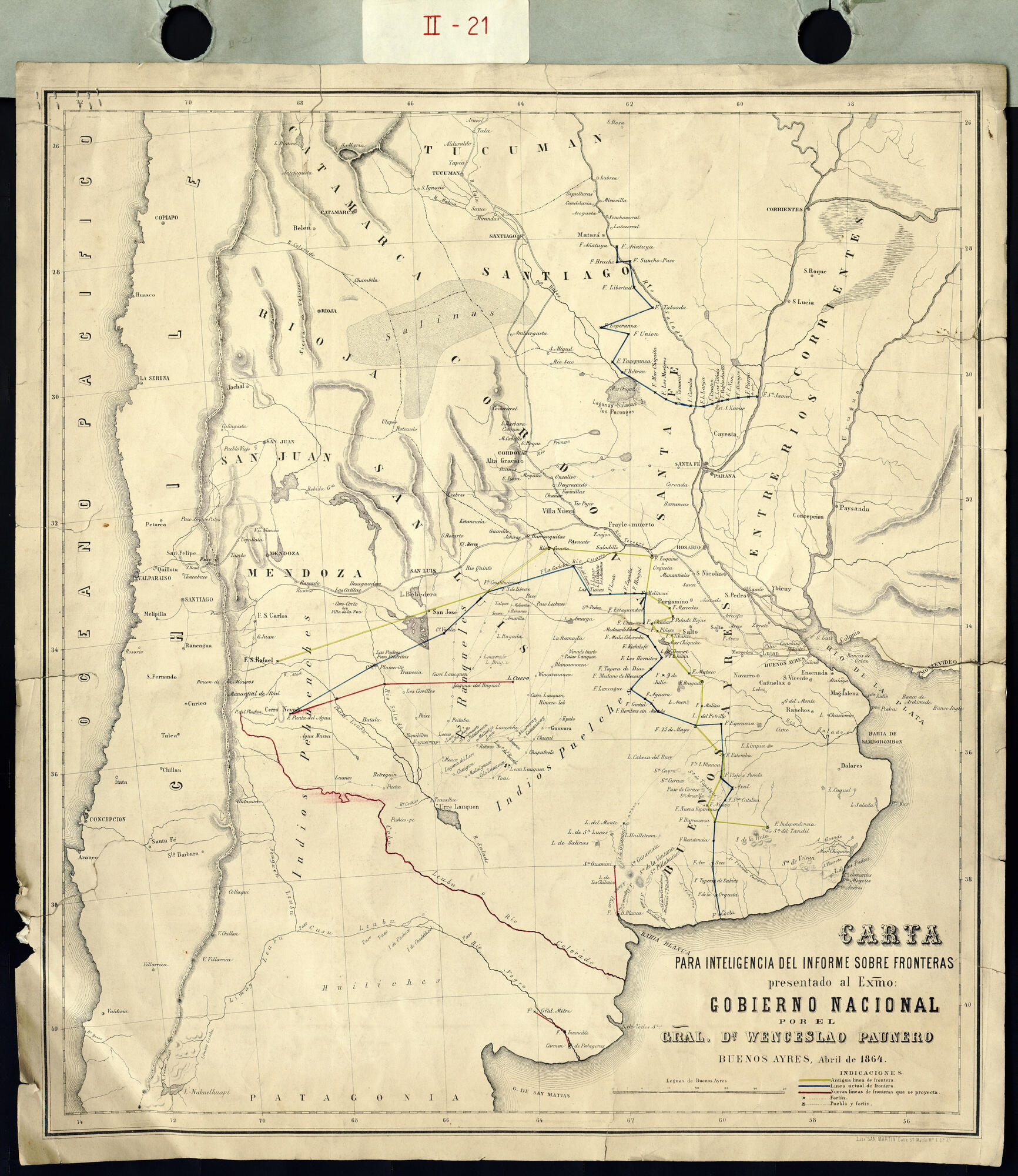
Dispossesions in the Americas

Dispossesions in the Americas

  • Home
  • Explore
  • About
  • Authors
  • Art
  • Bodies
  • Curricula
  • Cultural Heritage
  • Maps
  • Territories
Back to Explore
Map 1850 - 1880

Carta para la inteligencia del informe sobre fronteras presentado al Excelentísimo Gobierno nacional por el General Don Wenceslao Paunero. Impreso

  • WENCESLAO PAUNERO

Published: 1864

  • Download Image

Peoples

  • PEHUENCHES
  • HUILICHES
  • RANQUELES
  • PUELCHES

Citation

Carta para la inteligencia del informe sobre fronteras presentado al Excelentísimo Gobierno nacional por el General Don Wenceslao Paunero. Impreso. Map. Buenos Aires, Argentina: Gobierno Nacional, 1864. Accessed June 29, 2023. https://atom.mininterior.gob.ar/index.php/carta-para-la-inteligencia-del-informe-sobre-fronteras-presentado-al-excelentisimo-gobierno-nacional-por-el-general-don-wenceslao-paunero-impreso.

  • Download Image

Reading in Spanish

Map 1850 - 1880

Carta para la inteligencia del informe sobre fronteras presentado al Excelentísimo Gobierno nacional por el General Don Wenceslao Paunero. Impreso

  • WENCESLAO PAUNERO

Published: 1864

  • Download Image
  • Download Image

Related Content

Cartografía social – confinamiento por la expansión minera en el sur de La Guajira

Cartografía social – confinamiento por la expansión minera en el sur de La Guajira

Map
"Territorio Indígena Cabagra (Bribri)

"Territorio Indígena Cabagra (Bribri)

Map 2010
Ethnolinguistic territories of the Californias

Ethnolinguistic territories of the Californias

Map 2007
MAPA 2. UBICACIÓN DE LOS ACTUALES PUEBLOS HUAORANI

MAPA 2. UBICACIÓN DE LOS ACTUALES PUEBLOS HUAORANI

Map 1981
The coexistence of indigenous peoples and the natural environment in Central America

The coexistence of indigenous peoples and the natural environment in Central America

Map 1900 - 1999
Pueblos del Chanar y el Algarrobo. Los Atacamas del Siglo XVII.

Pueblos del Chanar y el Algarrobo. Los Atacamas del Siglo XVII.

Map 1600
Carte 5: Le pays Wayãpi: Région méridionale

Carte 5: Le pays Wayãpi: Région méridionale

Map 1760 - 1790
The Caribee Islands and Guyana.

The Caribee Islands and Guyana.

Map 1700 - 1799

Dispossessions in the Americas

A project by

University of Pennsylvania

Copyright 2024

With support from

Mellon Foundation

Site design & development

Element 84

Art Credits

Carta para la inteligencia del informe sobre fronteras presentado al Excelentísimo Gobierno nacional por el General Don Wenceslao Paunero. Impreso. Map. Buenos Aires, Argentina: Gobierno Nacional, 1864. Accessed June 29, 2023. https://atom.mininterior.gob.ar/index.php/carta-para-la-inteligencia-del-informe-sobre-fronteras-presentado-al-excelentisimo-gobierno-nacional-por-el-general-don-wenceslao-paunero-impreso.

Site Pages

  • Home
  • Explore
  • About
  • Authors
  • Art
  • Bodies
  • Curricula
  • Cultural Heritage
  • Maps
  • Territories