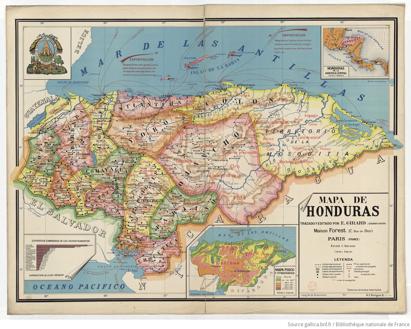
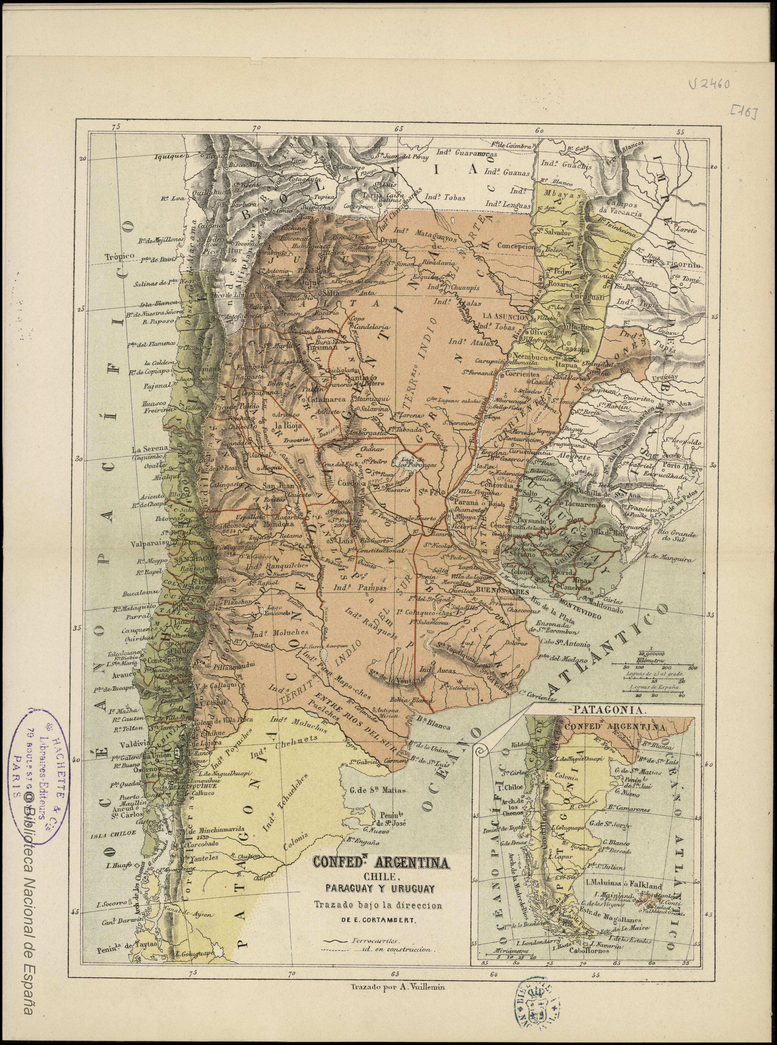
Dispossesions in the Americas

Dispossesions in the Americas

  • Home
  • Explore
  • About
  • Authors
  • Art
  • Bodies
  • Curricula
  • Cultural Heritage
  • Maps
  • Territories
Back to Explore
Map 1850

CONFED. ARGENTINA, CHILIE, PARAGUAY, Y URUGUAY.

  • CORTAMBERT, EUGÈNE

Published: 1850

  • Download Image

Peoples

  • CHIRIGUANO
  • TOBA
  • GUARANOCA
  • GUANAS
  • MBYA
  • LENGUA
  • MATACO
  • CHUNUPI
  • ATALALA
  • GUACHIS
  • TUPY
  • GUARANOCAS
  • GUANAS
  • LENGUAS
  • MATAGUAYOS
  • TOBAS
  • CHUNUPIS
  • ATALAS
  • PAMPAS
  • RANQUILCHES
  • MOLUCHES
  • RANQUELES
  • PUEN MAPUCHES
  • PUELCHES
  • CHEHUETS
  • POYUCHES
  • TECHUELCHES
  • COLUQUCOCHES

Citation

Cortambert, Eugène. "Confed. Argentina, Chilie, Paraguay, y Uruguay." Map. In Pequeño atlas de Geografía moderna, 36. Paris: Librería de Hachette y Cía, n.d. Accessed May 6, 2023. http://bdh.bne.es/bnesearch/detalle/bdh0000000261.

  • Download Image

Reading in Spanish

Map 1850

CONFED. ARGENTINA, CHILIE, PARAGUAY, Y URUGUAY.

  • CORTAMBERT, EUGÈNE

Published: 1850

  • Download Image
  • Download Image

Reading in Portuguese

Map 1850

CONFED. ARGENTINA, CHILIE, PARAGUAY, Y URUGUAY.

  • CORTAMBERT, EUGÈNE

Published: 1850

  • Download Image

Peoples

  • CHIRIGUANO
  • TOBA
  • GUARANOCA
  • GUANAS
  • MBYA
  • LENGUA
  • MATACO
  • CHUNUPI
  • ATALALA
  • GUACHIS
  • TUPY
  • GUARANOCAS
  • GUANAS
  • LENGUAS
  • MATAGUAYOS
  • TOBAS
  • CHUNUPIS
  • ATALAS
  • PAMPAS
  • RANQUILCHES
  • MOLUCHES
  • RANQUELES
  • PUEN MAPUCHES
  • PUELCHES
  • CHEHUETS
  • POYUCHES
  • TECHUELCHES
  • COLUQUCOCHES

Citation

Cortambert, Eugène. "Confed. Argentina, Chilie, Paraguay, y Uruguay." Map. In Pequeño atlas de Geografía moderna, 36. Paris: Librería de Hachette y Cía, n.d. Accessed May 6, 2023. http://bdh.bne.es/bnesearch/detalle/bdh0000000261.

  • Download Image

Related Content

Mapa de Honduras,  with Mapa Físico y Etnográfico (insert)

Mapa de Honduras, with Mapa Físico y Etnográfico (insert)

Map 1929
The Spanish and Musketor shore and the bay of Honduras and the islands adjacent

The Spanish and Musketor shore and the bay of Honduras and the islands adjacent

Map 1735
PUEBLO OMAGUA

PUEBLO OMAGUA

Map 2021
Intendencias y gobiernos militares de la Nueva España en 1800

Intendencias y gobiernos militares de la Nueva España en 1800

Map 1800
Santa Anna

Santa Anna

Map 1997
EL SEÑORÍO AYMARA DE LOS SURAS EN EL SIGLO XVI

EL SEÑORÍO AYMARA DE LOS SURAS EN EL SIGLO XVI

Map 1500 - 1699
Areas culturales de los pueblos indígenas del Ecuador

Areas culturales de los pueblos indígenas del Ecuador

Map 1997
YUCATÁN

YUCATÁN

Map 2015

Dispossessions in the Americas

A project by

University of Pennsylvania

Copyright 2024

With support from

Mellon Foundation

Site design & development

Element 84

Art Credits

Cortambert, Eugène. “Confed. Argentina, Chilie, Paraguay, y Uruguay.” Map. In Pequeño atlas de Geografía moderna, 36. Paris: Librería de Hachette y Cía, n.d. Accessed May 6, 2023. http://bdh.bne.es/bnesearch/detalle/bdh0000000261.

Site Pages

  • Home
  • Explore
  • About
  • Authors
  • Art
  • Bodies
  • Curricula
  • Cultural Heritage
  • Maps
  • Territories