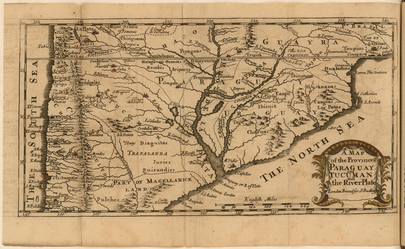
Dispossesions in the Americas

Dispossesions in the Americas

  • Home
  • Explore
  • About
  • Authors
  • Art
  • Bodies
  • Curricula
  • Cultural Heritage
  • Maps
  • Territories
Back to Explore
Map 1698

A Map of the Provinces Paraguay and Tucuman with the River Plate

  • D'Acugna, Christopher

Published: 1698

  • Download Image

Peoples

  • DIAGUITAS
  • QUERANDIES
  • PULCHES
  • MOCOBI

Citation

D'Acugna, Christopher. "A Map of the Provinces Paraguay and Tucuman with the River Plate." Map. 1698. Accessed March 10, 2022. https://jcb.lunaimaging.com/luna/servlet/detail/JCBMAPS~1~1~5556~115901221:A-Map-of-the-Provinces-Paraguay-and?sort=normalized_date%2Cfile_name%2Csource_author%2Csource_title#

  • Download Image

Reading in Spanish

Map 1698

A Map of the Provinces Paraguay and Tucuman with the River Plate

  • D'Acugna, Christopher

Published: 1698

  • Download Image
  • Download Image

Related Content

Indigenous groups and Miskitu settlements in eastern Nicaragua.

Indigenous groups and Miskitu settlements in eastern Nicaragua.

Map 1990
Plan del Partido de Santa Fé de Atun Jauxa, hecho por orden del Sr. D. Juan María de Gálvez y Montes de Oca, primer Gobernador Intendente del Departamento de Tarma. Año de 1785.

Plan del Partido de Santa Fé de Atun Jauxa, hecho por orden del Sr. D. Juan María de Gálvez y Montes de Oca, primer Gobernador Intendente del Departamento de Tarma. Año de 1785.

Map 1785
A Sequel of the Seat of War in the West Indies containing… Sub-map title: A large & accurate MAP of part of the Isthmus of Panama, taken from a Spanish drought exhibiting the Country adjacent to that City and Puerto Bello, with the Roads and Course of the River CHAGRE, by which the Treasure of the South Sea is conveyed a cross the Isthmus

A Sequel of the Seat of War in the West Indies containing… Sub-map title: A large & accurate MAP of part of the Isthmus of Panama, taken from a Spanish drought exhibiting the Country adjacent to that City and Puerto Bello, with the Roads and Course of the River CHAGRE, by which the Treasure of the South Sea is conveyed a cross the Isthmus

Map 1740
Carta de la Costa de Mosquitos;con sus islas;cayos;bancos y bajos adyacentes entre dicha y la Isla de Jamayca

Carta de la Costa de Mosquitos;con sus islas;cayos;bancos y bajos adyacentes entre dicha y la Isla de Jamayca

Map 1767 - 1781
INTENDENCIA DE DURANGO

INTENDENCIA DE DURANGO

Map 1800
Plano hidrográphico de una parte del Orinoco, que comprende desde el caño de Guaruapo hasta la ysla de Faxardo, por el qual se manifiesta que el sitio más apto para establecer el nuevo fuerte es enfrente del castillo de San Francisco de Assis de la ciudad de Guayana

Plano hidrográphico de una parte del Orinoco, que comprende desde el caño de Guaruapo hasta la ysla de Faxardo, por el qual se manifiesta que el sitio más apto para establecer el nuevo fuerte es enfrente del castillo de San Francisco de Assis de la ciudad de Guayana

Map 1747
THE AYMARA POLITY OF THE LUPAQA: EASTERN INTER-ANDEAN VALLEY COLONIES UNDER INCA RULE 16TH CENTURY

THE AYMARA POLITY OF THE LUPAQA: EASTERN INTER-ANDEAN VALLEY COLONIES UNDER INCA RULE 16TH CENTURY

Map 1560 - 1567
Áreas culturales de Venezuela prehispánica

Áreas culturales de Venezuela prehispánica

Map 1490

Dispossessions in the Americas

A project by

University of Pennsylvania

Copyright 2024

With support from

Mellon Foundation

Site design & development

Element 84

Art Credits

D’Acugna, Christopher. “A Map of the Provinces Paraguay and Tucuman with the River Plate.” Map. 1698. Accessed March 10, 2022. https://jcb.lunaimaging.com/luna/servlet/detail/JCBMAPS~1~1~5556~115901221:A-Map-of-the-Provinces-Paraguay-and?sort=normalized_date%2Cfile_name%2Csource_author%2Csource_title#

Site Pages

  • Home
  • Explore
  • About
  • Authors
  • Art
  • Bodies
  • Curricula
  • Cultural Heritage
  • Maps
  • Territories