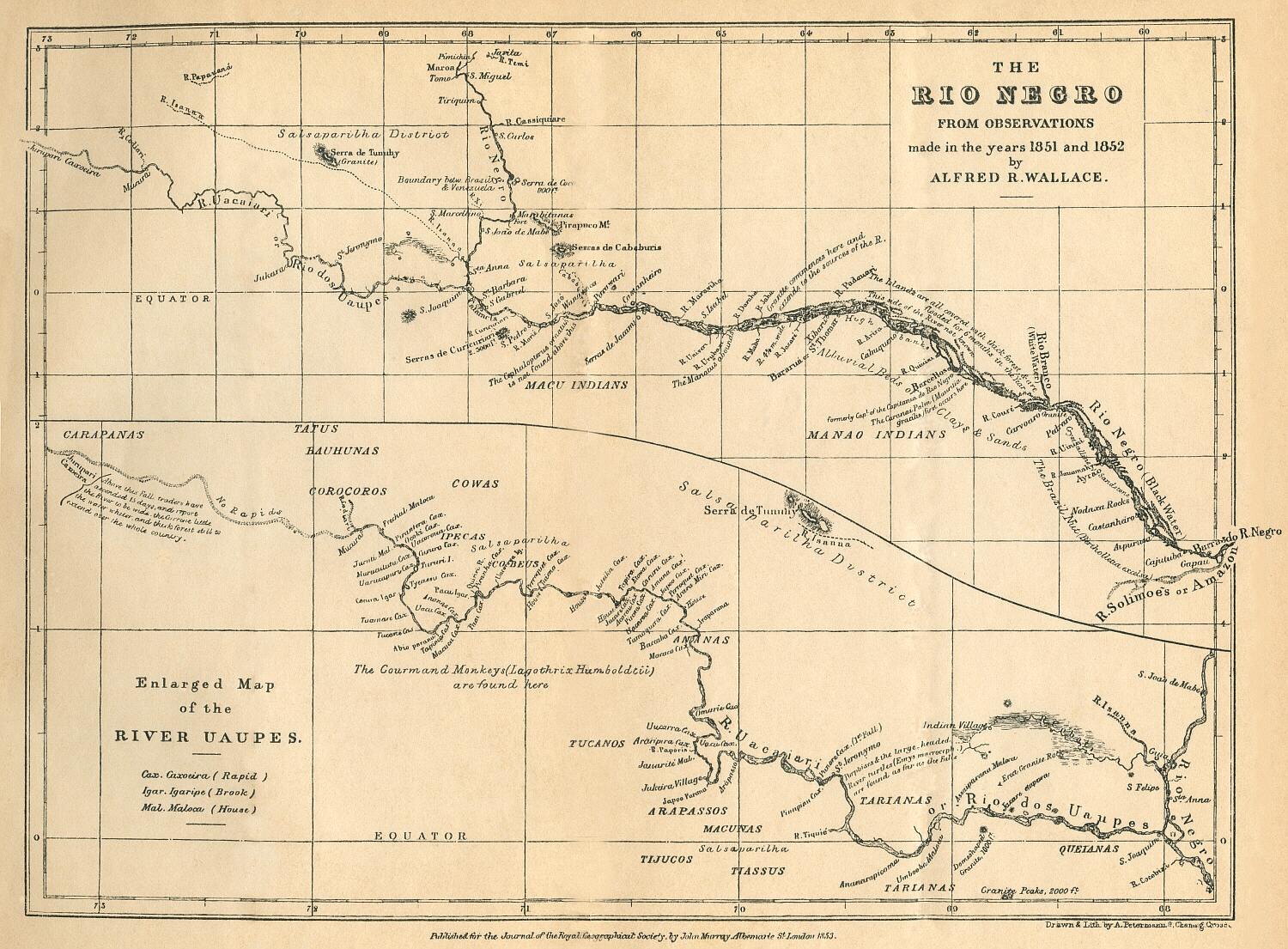
Dispossesions in the Americas

Dispossesions in the Americas

  • Home
  • Explore
  • About
  • Authors
  • Art
  • Bodies
  • Curricula
  • Cultural Heritage
  • Maps
  • Territories
Back to Explore
Map 1598

Fretum Magellannicum

  • Becker, Matthäus

Published: 1602

  • Download Image

Peoples

  • INDIOS

Citation

Becker, Matthäus. "Fretum Magellannicum." Map. The JCB Library. 1602. Accessed February 26, 2022. https://jcb.lunaimaging.com/luna/servlet/detail/JCBMAPS~1~1~1732~103610002:Fretum-Magellannicum,----?sort=normalized_date%2Cfile_name%2Csource_author%2Csource_title#

  • Download Image

Reading in Spanish

Map 1598

Fretum Magellannicum

  • Becker, Matthäus

Published: 1602

  • Download Image
  • Download Image

Reading in Portuguese

Map 1598

Fretum Magellannicum

  • Becker, Matthäus

Published: 1602

  • Download Image

Peoples

  • INDIOS

Citation

Becker, Matthäus. "Fretum Magellannicum." Map. The JCB Library. 1602. Accessed February 26, 2022. https://jcb.lunaimaging.com/luna/servlet/detail/JCBMAPS~1~1~1732~103610002:Fretum-Magellannicum,----?sort=normalized_date%2Cfile_name%2Csource_author%2Csource_title#

  • Download Image

Related Content

La Gaîté Parisienne [The Parisian Joy Series]

La Gaîté Parisienne [The Parisian Joy Series]

Artwork
THE RÍO NEGRO

THE RÍO NEGRO

Map 1851 - 1852
PUEBLO IÑAPARI

PUEBLO IÑAPARI

Map 2021
The Misquito: Most important municipios, 2001

The Misquito: Most important municipios, 2001

Map 2001
Nouvelle Carte de l'Amérique Méridionale, et des îles qui en dépendent dédiée à l'Academie royale des sciences de l'Institut de France.

Nouvelle Carte de l'Amérique Méridionale, et des îles qui en dépendent dédiée à l'Academie royale des sciences de l'Institut de France.

Map 1800 - 1899
SKETCH MAP OF THE MISSIONS OF THE CATALONIAN CAPUCHINS IN THE SPANISH PROVINCE OF GUAYANA ABOUT 1771

SKETCH MAP OF THE MISSIONS OF THE CATALONIAN CAPUCHINS IN THE SPANISH PROVINCE OF GUAYANA ABOUT 1771

Map 1771
Carte particulière de l'Isle de Cayenne avec les sondes

Carte particulière de l'Isle de Cayenne avec les sondes

Map 1600 - 1699
MAPA de las PROVINCIAS DE VENEZUELA Y DEL REINO DE SANTA FE

MAPA de las PROVINCIAS DE VENEZUELA Y DEL REINO DE SANTA FE

Map 1831

Dispossessions in the Americas

A project by

University of Pennsylvania

Copyright 2024

With support from

Mellon Foundation

Site design & development

Element 84

Art Credits

Becker, Matthäus. “Fretum Magellannicum.” Map. The JCB Library. 1602. Accessed February 26, 2022. https://jcb.lunaimaging.com/luna/servlet/detail/JCBMAPS~1~1~1732~103610002:Fretum-Magellannicum,----?sort=normalized_date%2Cfile_name%2Csource_author%2Csource_title#

Site Pages

  • Home
  • Explore
  • About
  • Authors
  • Art
  • Bodies
  • Curricula
  • Cultural Heritage
  • Maps
  • Territories