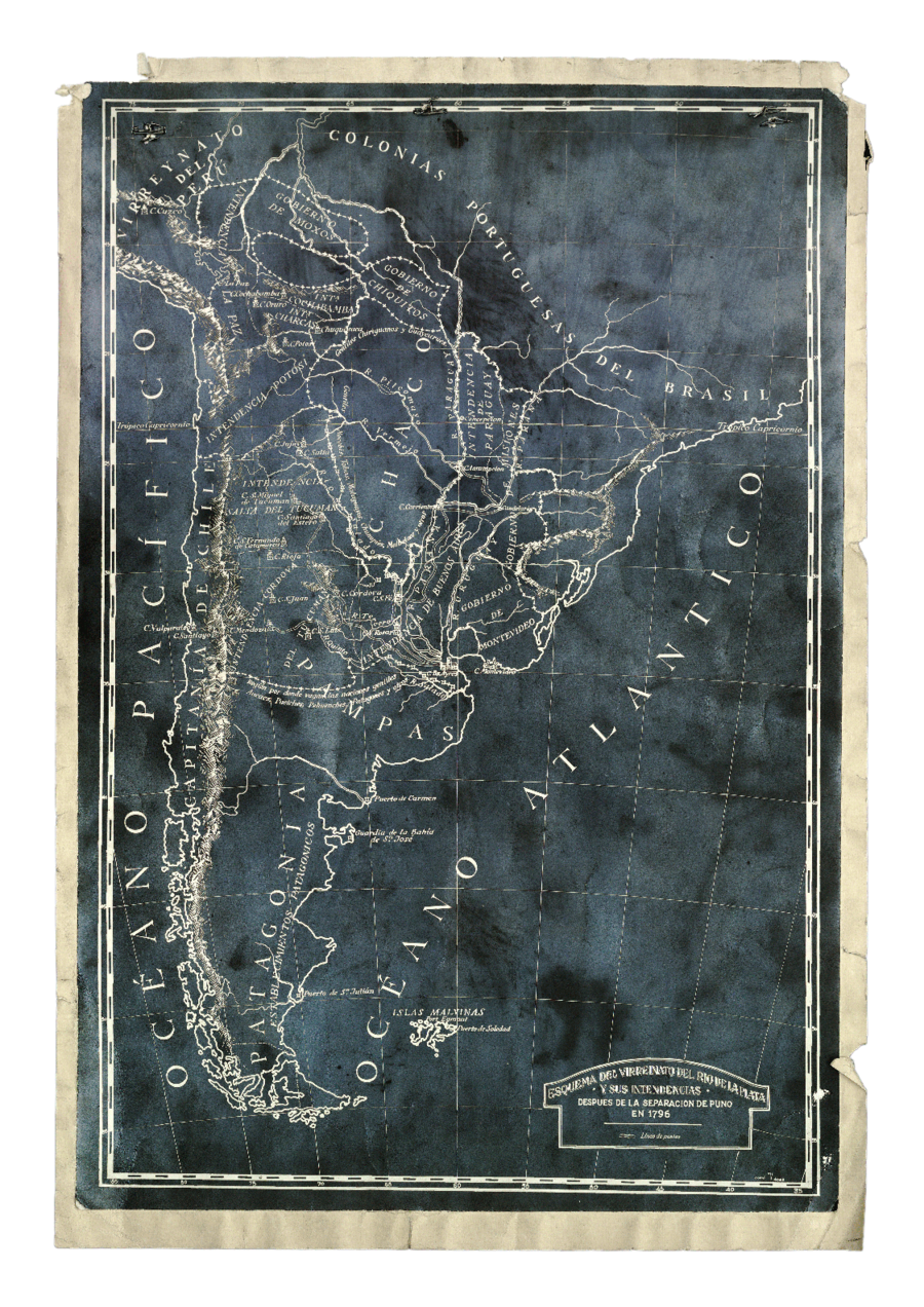
Dispossesions in the Americas

Dispossesions in the Americas

  • Home
  • Explore
  • About
  • Authors
  • Art
  • Bodies
  • Curricula
  • Cultural Heritage
  • Maps
  • Territories
Back to Explore
Map 1796

Esquema del virreinato del Río de la Plata y sus Intendencias después de la separación de Puno

  • Anonimo

Published: 1796

  • Download Image

Peoples

  • GUAYCURUES
  • MOCOVIES
  • CHIRIGUANOS
  • TOBAS
  • MOCOVI
  • CHUNUPIES
  • AUCAES
  • PUELCHES
  • PATAGONES
  • PEHUENCHES

Citation

Anonimo. Esquema del virreinato del Río de la Plata y sus Intendencias después de la separación de Puno, 1796. https://www.argentina.gob.ar/sites/default/files/3._el_virreinato_del_rio_de_la_plata.pdf

  • Download Image

Reading in Spanish

Map 1796

Esquema del virreinato del Río de la Plata y sus Intendencias después de la separación de Puno

  • Anonimo

Published: 1796

  • Download Image
  • Download Image

Reading in Portuguese

Map 1796

Esquema del virreinato del Río de la Plata y sus Intendencias después de la separación de Puno

  • Anonimo

Published: 1796

  • Download Image

Peoples

  • GUAYCURUES
  • MOCOVIES
  • CHIRIGUANOS
  • TOBAS
  • MOCOVI
  • CHUNUPIES
  • AUCAES
  • PUELCHES
  • PATAGONES
  • PEHUENCHES

Citation

Anonimo. Esquema del virreinato del Río de la Plata y sus Intendencias después de la separación de Puno, 1796. https://www.argentina.gob.ar/sites/default/files/3._el_virreinato_del_rio_de_la_plata.pdf

  • Download Image

Related Content

LOCALIZACION GEOGRAFICA DE LAS COMUNIDADES CIMARRONAS EN COLOMBIA DURANTE LOS SIGLOS XVI Y XVII

LOCALIZACION GEOGRAFICA DE LAS COMUNIDADES CIMARRONAS EN COLOMBIA DURANTE LOS SIGLOS XVI Y XVII

Map 1500 - 1699
ACTUAL TERRITORIO NUKAK

ACTUAL TERRITORIO NUKAK

Map 1978
Departamentos y municipios de mayor concentración del pueblo Arhuaco

Departamentos y municipios de mayor concentración del pueblo Arhuaco

Map 2005
A New Chart of the Coast of Brazil from the Banks of St. Roque, to the Island of St. Sebastian;with the Islands and Soundings in the Offing

A New Chart of the Coast of Brazil from the Banks of St. Roque, to the Island of St. Sebastian;with the Islands and Soundings in the Offing

Map 1794
A Gente Rio /We River

A Gente Rio /We River

Artwork
PUEBLO ACHUAR

PUEBLO ACHUAR

Map 2021
CARTA ETNOGRÁFICA DE MEXICO

CARTA ETNOGRÁFICA DE MEXICO

Map 1864
Terra Indígena Atikum

Terra Indígena Atikum

Map 1996 - 2021

Dispossessions in the Americas

A project by

University of Pennsylvania

Copyright 2024

With support from

Mellon Foundation

Site design & development

Element 84

Art Credits

Anonimo. Esquema del virreinato del Río de la Plata y sus Intendencias después de la separación de Puno, 1796. https://www.argentina.gob.ar/sites/default/files/3._el_virreinato_del_rio_de_la_plata.pdf

Site Pages

  • Home
  • Explore
  • About
  • Authors
  • Art
  • Bodies
  • Curricula
  • Cultural Heritage
  • Maps
  • Territories