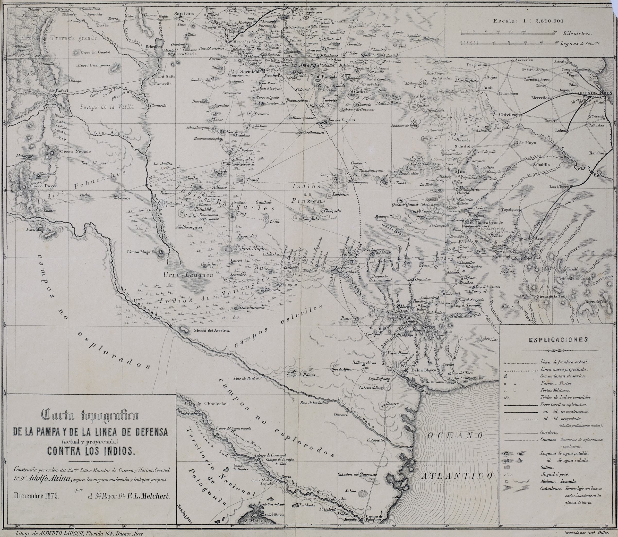
Dispossesions in the Americas

Dispossesions in the Americas

  • Home
  • Explore
  • About
  • Authors
  • Art
  • Bodies
  • Curricula
  • Cultural Heritage
  • Maps
  • Territories
Back to Explore
Map 1875

Carta topográfica de la Pampa y de la línea de defensa contra los indios.

  • Stiller Map

Published: 1875

  • Download Image

Peoples

  • RANQUEL
  • PEHUENCHES
  • INDIOS DE NAMUN CURA
  • INDIOS DE PINCEN

Citation

Stiller, Curt. Carta topográfica de la Pampa y de la línea de defensa contra los indios. Map. Buenos Aires: Litogr. de Alberto Larsch, 1875. https://catalogo.bn.gov.ar/exlibris1/apache_media/RN8H4KIJK539QUV2G9IT4QVX6G7UR2.jpg

  • Download Image

Reading in Spanish

Map 1875

Carta topográfica de la Pampa y de la línea de defensa contra los indios.

  • Stiller Map

Published: 1875

  • Download Image
  • Download Image

Related Content

Plan de la côte de la Guyane depuis la Riviere de Mahury jusqu'à celle de Macouria comprenant la rade de Cayenne Levé géométriquement en 1764 et 1765.

Plan de la côte de la Guyane depuis la Riviere de Mahury jusqu'à celle de Macouria comprenant la rade de Cayenne Levé géométriquement en 1764 et 1765.

Map 1764 - 1765
The Boundaries of Cuauhtinchan and Totomihuacan, Historia Tolteca-Chichimeca, pp. 1-2

The Boundaries of Cuauhtinchan and Totomihuacan, Historia Tolteca-Chichimeca, pp. 1-2

Map 1560
Location of three ethno-linguistic groups in the highlands of Guatemala in which joint InHerit-Riecken community-participant mapping took place. Adapted from http://d-maps. com/carte.php?num_car=1717&lang=en)

Location of three ethno-linguistic groups in the highlands of Guatemala in which joint InHerit-Riecken community-participant mapping took place. Adapted from http://d-maps. com/carte.php?num_car=1717&lang=en)

Map 2000
THE KARANQAS AYMARA POLITY UNDER SPANISH COLONIAL RULE IN THE 18TH CENTURY

THE KARANQAS AYMARA POLITY UNDER SPANISH COLONIAL RULE IN THE 18TH CENTURY

Map 1750 - 1804
CARTA del CANTON de CAYCARA de la Provincia de Guayana

CARTA del CANTON de CAYCARA de la Provincia de Guayana

Map 1840
PUEBLO CHOL

PUEBLO CHOL

Map 2020
Geographic Distribution of Huichol and Cora, Showing Towns and Elevations

Geographic Distribution of Huichol and Cora, Showing Towns and Elevations

Map 1969
Territorio de las Misiones Jesuí!cas de Guaraníes: Pueblo y estancias. Mediados del siglo XVIII

Territorio de las Misiones Jesuí!cas de Guaraníes: Pueblo y estancias. Mediados del siglo XVIII

Map 1700 - 1799

Dispossessions in the Americas

A project by

University of Pennsylvania

Copyright 2024

With support from

Mellon Foundation

Site design & development

Element 84

Art Credits

Stiller, Curt. Carta topográfica de la Pampa y de la línea de defensa contra los indios. Map. Buenos Aires: Litogr. de Alberto Larsch, 1875. https://catalogo.bn.gov.ar/exlibris1/apache_media/RN8H4KIJK539QUV2G9IT4QVX6G7UR2.jpg

Site Pages

  • Home
  • Explore
  • About
  • Authors
  • Art
  • Bodies
  • Curricula
  • Cultural Heritage
  • Maps
  • Territories