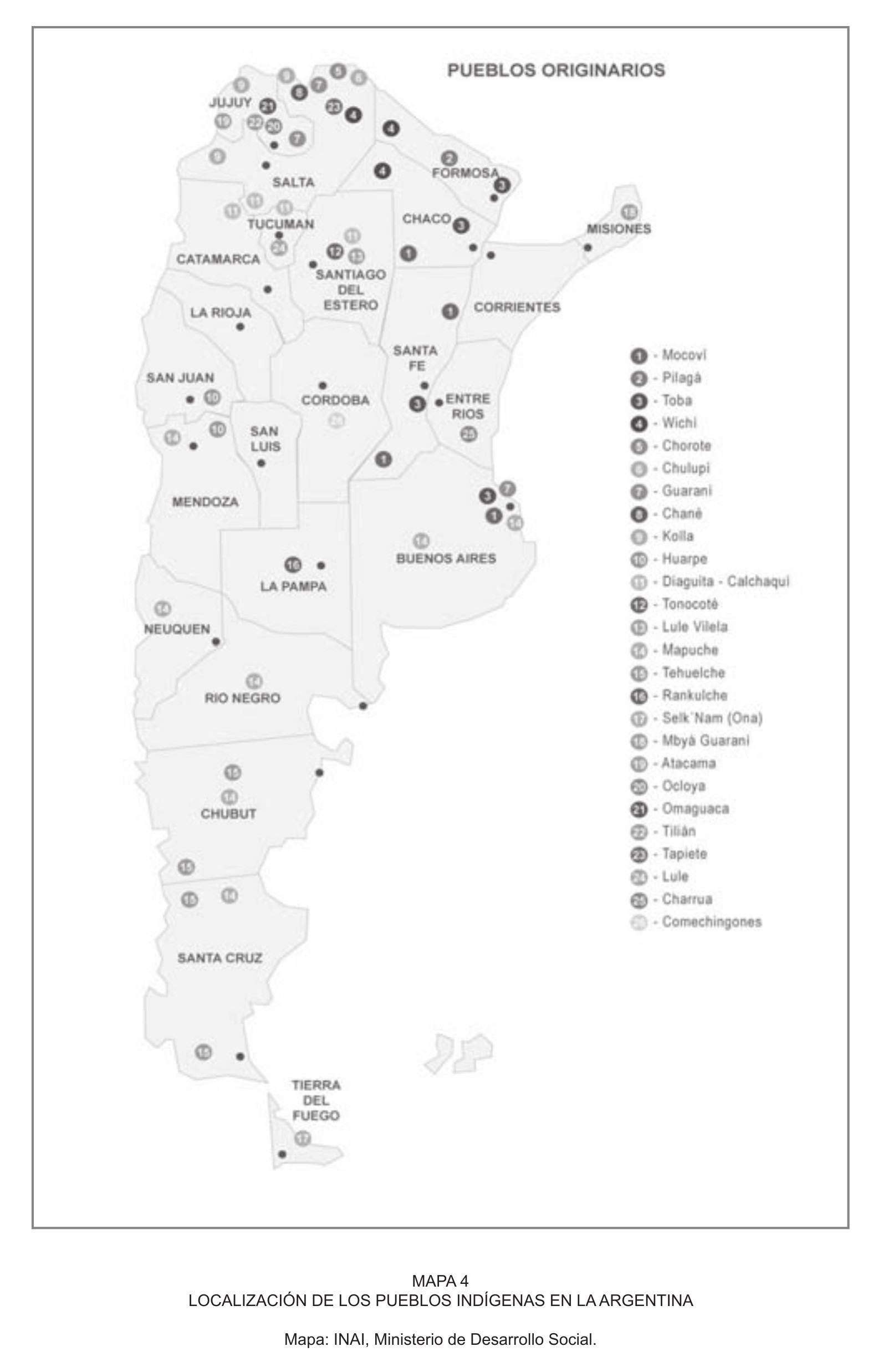
Dispossesions in the Americas

Dispossesions in the Americas

  • Home
  • Explore
  • About
  • Authors
  • Art
  • Bodies
  • Curricula
  • Cultural Heritage
  • Maps
  • Territories
Back to Explore
Map 2004

LOCALIZACIÓN DE LOS PUEBLOS INDÍGENAS EN LA ARGENTINA

  • INAI, Ministerio de Desarrollo Social

Published: 2011

  • Download Image

Peoples

  • MOCOVI
  • PILAGA
  • TOBA
  • WICHI
  • CHOROTE
  • CHULUPI
  • GUARANI
  • CHANE
  • KOLLA
  • HUARPE
  • DIAGUITA-CALCHAQUI
  • TONOCOTE
  • LULE-VILELA
  • MAPUCHE
  • TEHUELCHE
  • RANKULCHE
  • SELK'NAM
  • MBYA-GUARANI
  • ATACAMA
  • OCLOYA
  • OMAGUACO
  • TILIAN
  • TAPIETE
  • LULE
  • CHARRUA
  • COMECHINGONES

Citation

Salamanca, Carlos. "Movilizaciones indígenas, mapas e historias por la propiedad de la tierra en el Chaco argentino." Pg. 54. 2011. Accessed September 2021. https://www.corteidh.or.cr/tablas/r29865.pdf

  • Download Image

Reading in Spanish

Map 2004

LOCALIZACIÓN DE LOS PUEBLOS INDÍGENAS EN LA ARGENTINA

  • INAI, Ministerio de Desarrollo Social

Published: 2011

  • Download Image
  • Download Image

Reading in Portuguese

Map 2004

LOCALIZACIÓN DE LOS PUEBLOS INDÍGENAS EN LA ARGENTINA

  • INAI, Ministerio de Desarrollo Social

Published: 2011

  • Download Image

Peoples

  • MOCOVI
  • PILAGA
  • TOBA
  • WICHI
  • CHOROTE
  • CHULUPI
  • GUARANI
  • CHANE
  • KOLLA
  • HUARPE
  • DIAGUITA-CALCHAQUI
  • TONOCOTE
  • LULE-VILELA
  • MAPUCHE
  • TEHUELCHE
  • RANKULCHE
  • SELK'NAM
  • MBYA-GUARANI
  • ATACAMA
  • OCLOYA
  • OMAGUACO
  • TILIAN
  • TAPIETE
  • LULE
  • CHARRUA
  • COMECHINGONES

Citation

Salamanca, Carlos. "Movilizaciones indígenas, mapas e historias por la propiedad de la tierra en el Chaco argentino." Pg. 54. 2011. Accessed September 2021. https://www.corteidh.or.cr/tablas/r29865.pdf

  • Download Image

Related Content

"Territorio Indígena Malécu"

"Territorio Indígena Malécu"

Map 2010
Collection of different versions of the Peru Jaguar, Peru Otorongo, and the “Perucitos”

Collection of different versions of the Peru Jaguar, Peru Otorongo, and the “Perucitos”

Artwork
Carte nouvelle de la France Equinoctiale faite et présentée à sa Majesté par le SieurLe Febure de la Barre son Lieutenant Généralen ces pays au mois de septembre 1665

Carte nouvelle de la France Equinoctiale faite et présentée à sa Majesté par le SieurLe Febure de la Barre son Lieutenant Généralen ces pays au mois de septembre 1665

Map 1665
El descubrimiento del Amazonas [The Discovery of the Amazon]

El descubrimiento del Amazonas [The Discovery of the Amazon]

Artwork
Reclamo de la Comunidad Indígena Negra Creole de Bluefields y Territorio Títulados en la RAAS.

Reclamo de la Comunidad Indígena Negra Creole de Bluefields y Territorio Títulados en la RAAS.

Map 2000
Localización de los pueblos urus

Localización de los pueblos urus

Map 2014
Mapa 1. Ubicación geográfica del territorio Waorani

Mapa 1. Ubicación geográfica del territorio Waorani

Map 2018
PUEBLO IXIL

PUEBLO IXIL

Map 2020

Dispossessions in the Americas

A project by

University of Pennsylvania

Copyright 2024

With support from

Mellon Foundation

Site design & development

Element 84

Art Credits

Salamanca, Carlos. “Movilizaciones indígenas, mapas e historias por la propiedad de la tierra en el Chaco argentino.” Pg. 54. 2011. Accessed September 2021. https://www.corteidh.or.cr/tablas/r29865.pdf

Site Pages

  • Home
  • Explore
  • About
  • Authors
  • Art
  • Bodies
  • Curricula
  • Cultural Heritage
  • Maps
  • Territories