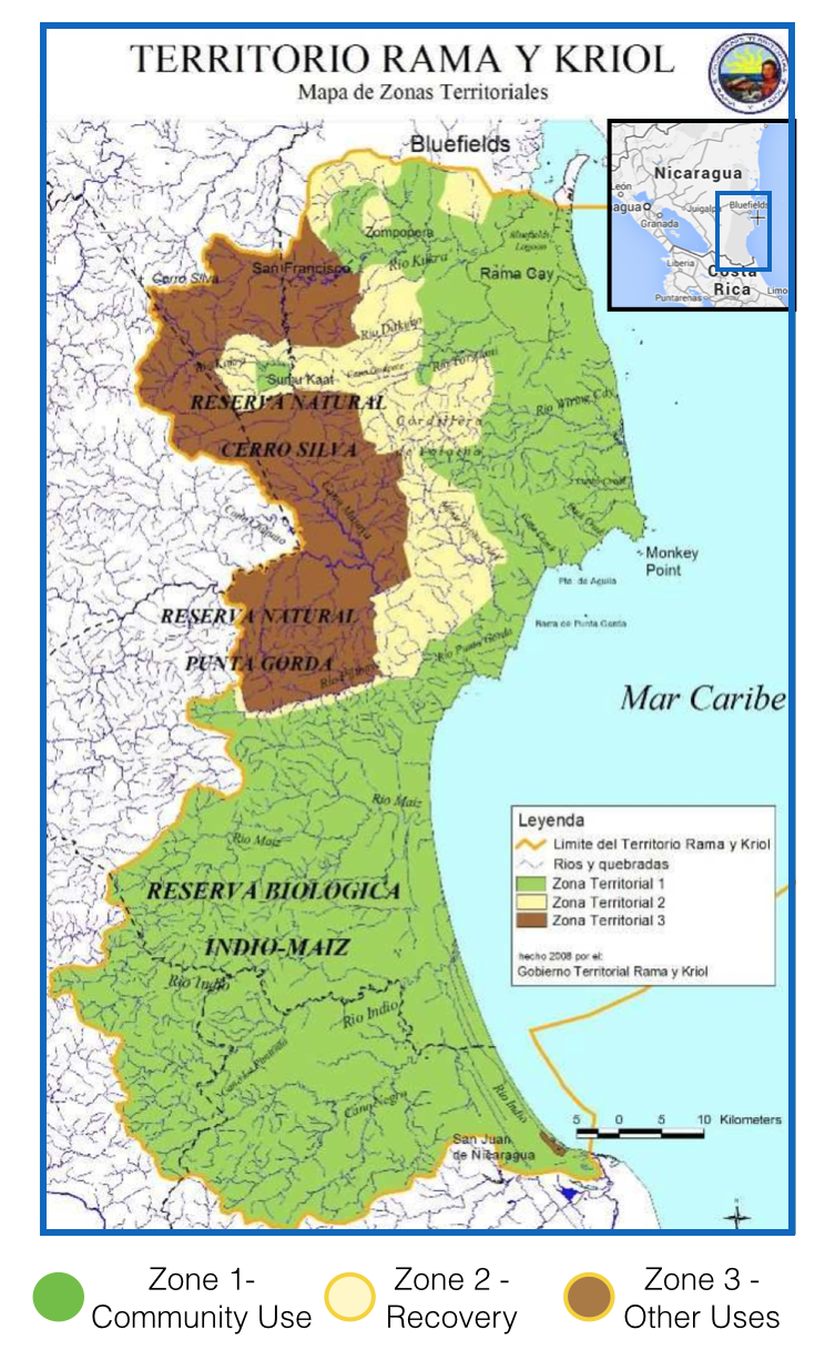
Dispossesions in the Americas

Dispossesions in the Americas

  • Home
  • Explore
  • About
  • Authors
  • Art
  • Bodies
  • Curricula
  • Cultural Heritage
  • Maps
  • Territories
Back to Explore
Map

Tribes of Chile and Northwest Argentina

    Published: 1946

    • Download Image

    Peoples

    • TARAPACA
    • AYMARA
    • CHICHA
    • LIPE
    • ATACAMA
    • DIAGUITA
    • HUARPE
    • COMECHINGON
    • PUELCHE
    • PEHUENCHE
    • ARAUCANIANS
    • MAPUCHE
    • PICUNCHE
    • HUILLICHE
    • POYAS
    • NORTHERN TEHUELCHE
    • CHILOTE
    • CHONO

    Citation

    Steward Julian Haynes, Editor. Handbook of South American Indians. Washington, U.S. G.P.O.

    • Download Image

    Reading in Spanish

    Map

    Tribes of Chile and Northwest Argentina

      Published: 1946

      • Download Image
      • Download Image

      Reading in Portuguese

      Map

      Tribes of Chile and Northwest Argentina

        Published: 1946

        • Download Image

        Peoples

        • TARAPACA
        • AYMARA
        • CHICHA
        • LIPE
        • ATACAMA
        • DIAGUITA
        • HUARPE
        • COMECHINGON
        • PUELCHE
        • PEHUENCHE
        • ARAUCANIANS
        • MAPUCHE
        • PICUNCHE
        • HUILLICHE
        • POYAS
        • NORTHERN TEHUELCHE
        • CHILOTE
        • CHONO

        Citation

        Steward Julian Haynes, Editor. Handbook of South American Indians. Washington, U.S. G.P.O.

        • Download Image

        Related Content

        Territorios del Pueblo Barí reconocidos por el Estado Colombiano (2017)

        Territorios del Pueblo Barí reconocidos por el Estado Colombiano (2017)

        Map 2017
        Outside Threats to Maya Lands

        Outside Threats to Maya Lands

        Map 1997
        MAPPA DO IMPERIO DO BRAZIL

        MAPPA DO IMPERIO DO BRAZIL

        Map 1878
        Map of Tenango (Valley of Mexico), 1587, Archivo General de la Nación, no. 1822

        Map of Tenango (Valley of Mexico), 1587, Archivo General de la Nación, no. 1822

        Map 1587
        Bedxe´Guie´ [Sacred Land]

        Bedxe´Guie´ [Sacred Land]

        Artwork
        Territorio Rama y Kriol: Mapa de Zonas Territoriales. Three Zones proposed by the PADA to ensure a sustainable future for the communities of Rama and Kriol

        Territorio Rama y Kriol: Mapa de Zonas Territoriales. Three Zones proposed by the PADA to ensure a sustainable future for the communities of Rama and Kriol

        Map 2000
        Planta regular de la fortaleza y castillo de Huehuetenango, sobre las márgenas de Socoleo.

        Planta regular de la fortaleza y castillo de Huehuetenango, sobre las márgenas de Socoleo.

        Map 1672
        Mosquitia or The Mosquito Shore with The Eastern Part of Yucatán as far as the 20th Degree of North Latitude

        Mosquitia or The Mosquito Shore with The Eastern Part of Yucatán as far as the 20th Degree of North Latitude

        Map 1787

        Dispossessions in the Americas

        A project by

        University of Pennsylvania

        Copyright 2024

        With support from

        Mellon Foundation

        Site design & development

        Element 84

        Art Credits

        Steward Julian Haynes, Editor. Handbook of South American Indians. Washington, U.S. G.P.O.

        Site Pages

        • Home
        • Explore
        • About
        • Authors
        • Art
        • Bodies
        • Curricula
        • Cultural Heritage
        • Maps
        • Territories