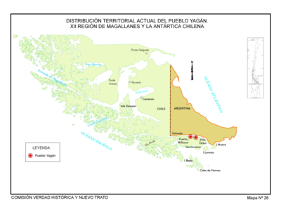
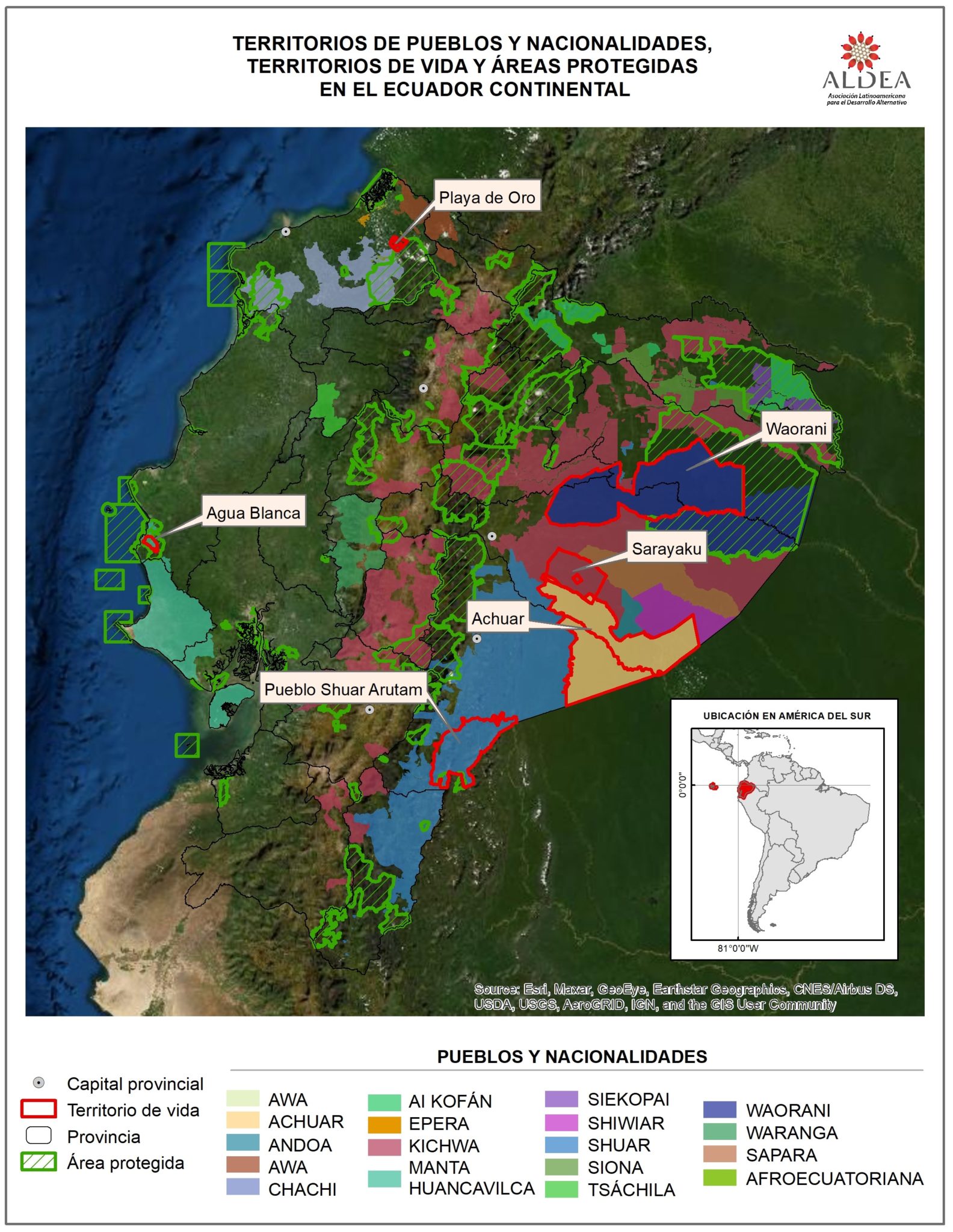
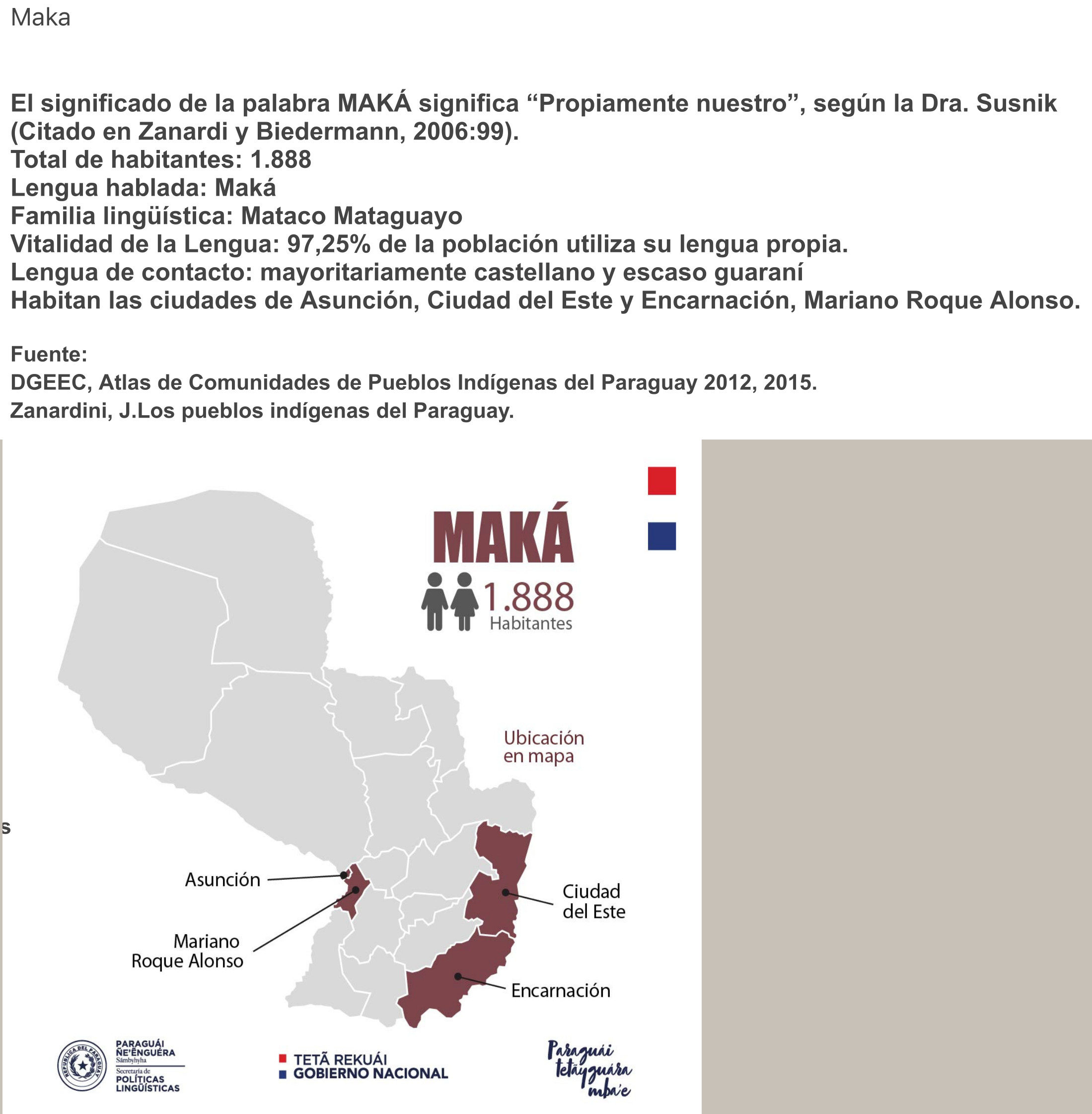
Dispossesions in the Americas

Dispossesions in the Americas

  • Home
  • Explore
  • About
  • Authors
  • Art
  • Bodies
  • Curricula
  • Cultural Heritage
  • Maps
  • Territories
Back to Explore
Map 2020

Distribución geográfica de los Pueblos Originarios según Comunidades registradas en el ámbito nacional y/o provincial

  • Área de Georreferenciamiento del Programa Relevamiento Territorial de Comunidades Indígenas

Published: 2020

  • Download Image

Peoples

  • ATACAMA
  • CHANE
  • CHARRUA
  • CHICHA
  • NIVACLE
  • HENIA-KAMIARE
  • CORUNDI
  • DIAGUITA
  • FISCARA
  • GUARANI
  • GUAYCURU
  • HUARPE
  • LOGYS
  • KOLLA
  • KOLLA-ATACAMENO
  • LULE
  • VILELA
  • MAPUCHE
  • MAPUCHE-TEHUELCHE
  • MBYA
  • MOQOIT
  • OCLOYA
  • OMAGUACA
  • PILAGA
  • QOM
  • QUECHUA
  • RANKULCHE
  • SANAVIRON
  • SELK-NAM
  • TAPIETE
  • TASTIL
  • TEHUELCHE
  • TILIAN
  • TOARA
  • TONOKOTE
  • WICHI

Citation

Mapa de pueblos originarios. Map. Instituto nacional de asuntos indígenas, 2020. Accessed March 30, 2021. https://www.argentina.gob.ar/derechoshumanos/inai/mapa.

  • Download Image

Reading in Spanish

Map 2020

Distribución geográfica de los Pueblos Originarios según Comunidades registradas en el ámbito nacional y/o provincial

  • Área de Georreferenciamiento del Programa Relevamiento Territorial de Comunidades Indígenas

Published: 2020

  • Download Image
  • Download Image

Related Content

Distribucion Territorial Actual de las Comunidades Quechua

Distribucion Territorial Actual de las Comunidades Quechua

Map 1993
The Bay of Honduras

The Bay of Honduras

Map 1775
DURANGO

DURANGO

Map 2015
"Transversalidad Histórica entre las Tierras Indidas de 1940 y los Pueblos Indígenas de Costa Rica en la actualidad"

"Transversalidad Histórica entre las Tierras Indidas de 1940 y los Pueblos Indígenas de Costa Rica en la actualidad"

Map 1940 - 2014
‘INDIAN ROYAL TOWNS’ (REDUCCIONES) AND SACRED SPACES UNDER SPANISH COLONIAL RULE IN THE TERRITORY OF THE PRE-COLONIAL AYMARA POLITY OF THE PAKAXA IN THE LATE 16TH CENTURY

‘INDIAN ROYAL TOWNS’ (REDUCCIONES) AND SACRED SPACES UNDER SPANISH COLONIAL RULE IN THE TERRITORY OF THE PRE-COLONIAL AYMARA POLITY OF THE PAKAXA IN THE LATE 16TH CENTURY

Map 1570 - 1650
PUEBLO HUASTECO

PUEBLO HUASTECO

Map 2020
Distribution of Tarascan Speech by Settlements, 1940

Distribution of Tarascan Speech by Settlements, 1940

Map 1940
CARTA GEOGRÁFICA DE UNA GRAN PARTE DE LA AMERICA SEPTENTRIONAL

CARTA GEOGRÁFICA DE UNA GRAN PARTE DE LA AMERICA SEPTENTRIONAL

Map 1832

Dispossessions in the Americas

A project by

University of Pennsylvania

Copyright 2024

With support from

Mellon Foundation

Site design & development

Element 84

Art Credits

Mapa de pueblos originarios. Map. Instituto nacional de asuntos indígenas, 2020. Accessed March 30, 2021. https://www.argentina.gob.ar/derechoshumanos/inai/mapa.

Site Pages

  • Home
  • Explore
  • About
  • Authors
  • Art
  • Bodies
  • Curricula
  • Cultural Heritage
  • Maps
  • Territories