Abstract
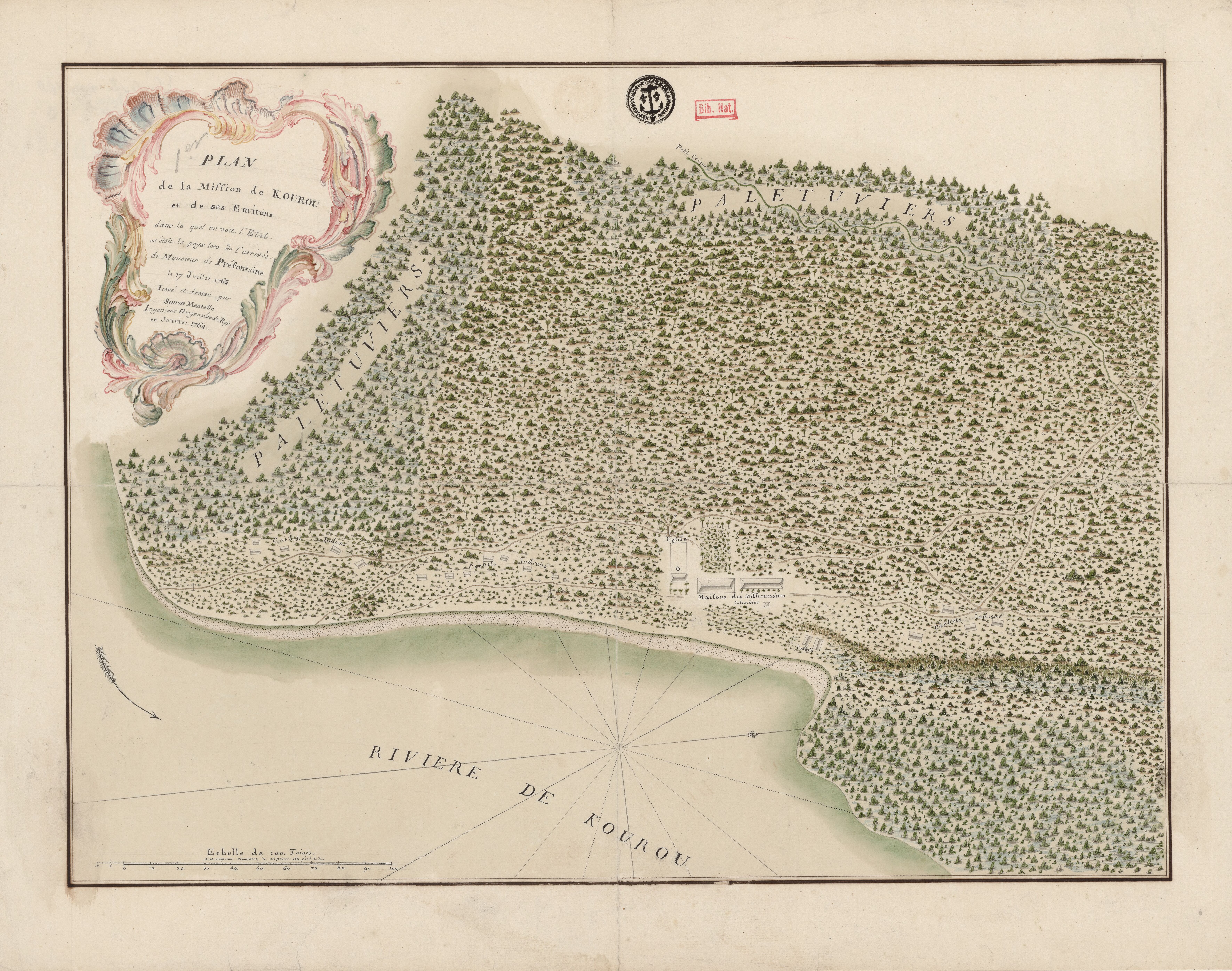
In 1763, the royal engineer and geographer François-Simon Mentelle (1731-1799) created a map of the Mission of Kourou, which was one of the first Jesuit mission and played a crucial role in the colonial history of French Guiana. The expansion of European culture via religious missionaries was highly successful in several parts of the Americas, including Ecuador, New Granada, and Paraguay. Notably, the missions ruled by the Jesuit friars achieved stability and became economically profitable by extracting labor from the Indigenous people.1 In the case of French Guiana, both the political and social organization of the colony will find a common ground on the religious missions.2
The Jesuits established six missions in the territory of present-day French Guiana. Although they arrived in the late 17th century, their first permanent settlement was Kourou, founded by Father Lombard in 1712. The mission included people from the Kali’na and Acoqua groups.3 Other missions also included nomadic and sedentary groups, such as those in the Oyapock and Sinnamary rivers.4 The missions produced cotton, sugar, coffee, cacao, ginger, and tobacco. Still, the lack of more population economically active in favor of the crown was French Guiana’s most pervasive problem under the French eyes.5 The exportations of the colony paled in comparison of the more fruitful sugar plantations in the Caribbean, such as Saint Domingue and Guadeloupe.
Kourou, the location of the first Jesuit mission, played a crucial role in the project of establishing a new colony with European immigrants. In 1763, the French Government, under the leadership of the Duke of Choiseul (1719-1785), implemented a recruitment strategy to persuade men and women to migrate from Europe to the mission in South America. The plan was successful, and approximately 17,000 people, mainly from France and Germany, participated in the project.6 The success of the recruitment efforts was partly due to narratives created within French Guiana. Jean Antoine Bruletout de Préfontaine (1717-1787) was a key figure. Prefontaine, a French military officer, began his career in Cayenne, the largest town in the colony and most important port, in the late 1730s when he arrived as a Lieutenant. He was promoted to Captain in 1754 and became Colonel of Infantry and Commander of Kourou in 1762. He remained in Guiana until his passing in 1787.7
In 1763, Préfontaine published an account of his socioeconomic and cultural observation of Guiana. In Maison Rustique, the military man described the uses and customs of the locals, particularly the maroon communities along the Maroni and Oyapock rivers, which nowadays mark the international borders with Suriname and Brazil, respectively. He briefly mentioned his interaction with the Galibis, Palicours, Ijoutanes, Maillés (Mayez), and Maraones.8 Préfontaine’s work was published coincidentally with the development of the expedition to Kourou. The detailed description of the people and agricultural products highlighted the colony’s potential for increasing productivity and economic growth. Additionally, Préfontaine sent a map Carte géographique de l'isle de Cayenne et de ses environs dressée sur les observations estimées et les remarques de Mr de Préfontaine of the Guiana with a precise description of the Indigenous populations living on the margins of the Oyapock River. Thus, the book was a form of propaganda for the enterprise of Choiseul, minister of King Louis XIV.9
Another form of propaganda was visual. Mentelle created several French Guiana maps, including information about the Indigenous population.10 The map you see at the front of this essay is possibly on one of the first maps after his arrival in July 1763. It is noticeable how the only easily recognizable human settlements on the map are the church and the missionaries’ houses, surrounded by exuberant vegetation.11 Several “carbet d’indians” (Indigenous People’s dwellings) are depicted within the forest. The unnamed Indigenous people were the Kalin’a (Galibi, as they appear in most maps of the time), ancestral inhabitants of Cayenne who gradually gathered in Kourou. The mission also included other indigenous communities, such as the Arouas, as mentioned by Father Lombard.12
Duke of Choiseul’s expedition to French Guiana suffered from little organization since the beginning. Most of the travelers experienced hunger and sickness even before departing Europe. The precarity worsened upon reaching the American coasts, as the port of Cayenne, town settlement lacked the infrastructure and the resources to hold the expedition.13 The situation reached a tragic denouement in Kourou, where the Europeans faced lethal situations of hunger and illness. Historians estimate that the enterprise costed the life of between 7,000 and 9,000 Europeans.14
Map citation:
Mentelle, Fr. Simon. Plan de la Mission de Kourou et de ses Environs dans lequel on voit l’Etat dans lequel étoit le pays lors de l’arrivée de Monsieur de Préfontaine le 17 juillet 1763. Map, 48 x 60,5 cm. Bibliothèque National de France – Gallica. https://gallica.bnf.fr/ark:/12148/btv1b53103659w
In the case of the Viceroyalty of New Granada, in the territories of current Colombia, appears the study by German Colmenares, Las haciendas de los Jesuitas en el Nuevo Reino de Granada (Bogotá: Universidad Nacional de Colombia, 1969). ↩︎
Pierre Pluchon and Lucien-René Abénon, Histoire des Antilles et de la Guyane (Toulouse: Privat, 1982), 43. ↩︎
Marion F. Godfroy, Kourou and the Struggle for a French America (Houndmills, Basingstoke, Hampshire: Palgrave Macmillan, 2015), 70. ↩︎
Serge Mam-Lam-Fouck and Apollinaire Anakesa-Kululuka, Nouvelle histoire de la Guyane Française: des souverainetés amérindiennes aux mutations de la société (Matoury, Guyane: Ibis rouge, 2013), 36. ↩︎
Assemblée Nationale (France), “N. 1924. Rapport d’information Déposé En Application De l’article 145 Du Règlement Par La Mission d’information sur l’aménagement et le développement durables du territoire en Guyane,” (November 28, 2023), 19-20. Assemblée Nationale. Accessed, September 16, 2024. www.assemblee-nationale.fr/dyn/16/rapports/cion-dvp/l16b1924_rapport-information.pdf ↩︎
Godfroy, Kourou, 104. ↩︎
Emilie** d’Orgeix & Céline **Frémaux, « La petite maison dans les abattis ou l’art de rédiger aux bois par Jean Antoine de Brûletout, chevalier de Préfontaine dans son habitation de la France équinoxiale (1754-1763) », In Situ 21 (2013): paragraphs 6-7, 25. DOI : https://doi.org/10.4000/insitu.10338. His file of services remains at the Archives Nationales D’Outre Mer, Aix-en-Provence, Secrétariat d’Etat à la Marine. Personnel colonial ancient, COL E 341. https://recherche-anom.culture.gouv.fr/ark:/61561/up424qlprne/daogrp/0/1 ↩︎
Jean Antoine Bruletout de Préfontaine, Maison rustique, à l’usage des habitans de la partie de la France équinoxiale connue sous le nom de Cayenne, (A Paris, quai des Augustins, chez Cl. J. B. Bauche, libraire, à Sainte Geneviève, & à Saint Jean dans le Désert. M. DCC. LXIII), 132-134 ↩︎
D’Orgeix** & Céline **Frémaux, « La petite maison dans les abattis, » 23. ↩︎
See, and “Carte de la Guiane Françoise dresée à Cayenne par l’ordre du Gouvernement.” Manuscript, watercolor and ink on paper, 66 x 88 cm. Cayenne, 1777. Archives Nationales d’Outre Mer. Accessed, July 15, 2024. http://anom.archivesnationales.culture.gouv.fr/ulysse/osd?id=FR_ANOM_14DFC317A&id=FR_ANOM_14DFC317A ↩︎
About the life of Mentelle: Societé de Gens de Lettres et Savants, Biographie universelle, ancienne et moderne, Suplement, Tome 73 (Paris: Chez L.G. Michaud, 1843), 447-450. ↩︎
Lombard, “Lettres du P. Lombard,” in Mission de Cayenne et de la Guyane française compiled by Fortuné de Montezon (Paris: Julien, Lanier, Cosnard, 1853), 271-273, 299. ↩︎
Godfroy, Kourou, 125. ↩︎
Godfroy, Kourou, 169; Mam-Lam-Fouck and Anakesa-Kululuka, Nouvelle histoire de la Guyane française, 39-40. ↩︎

