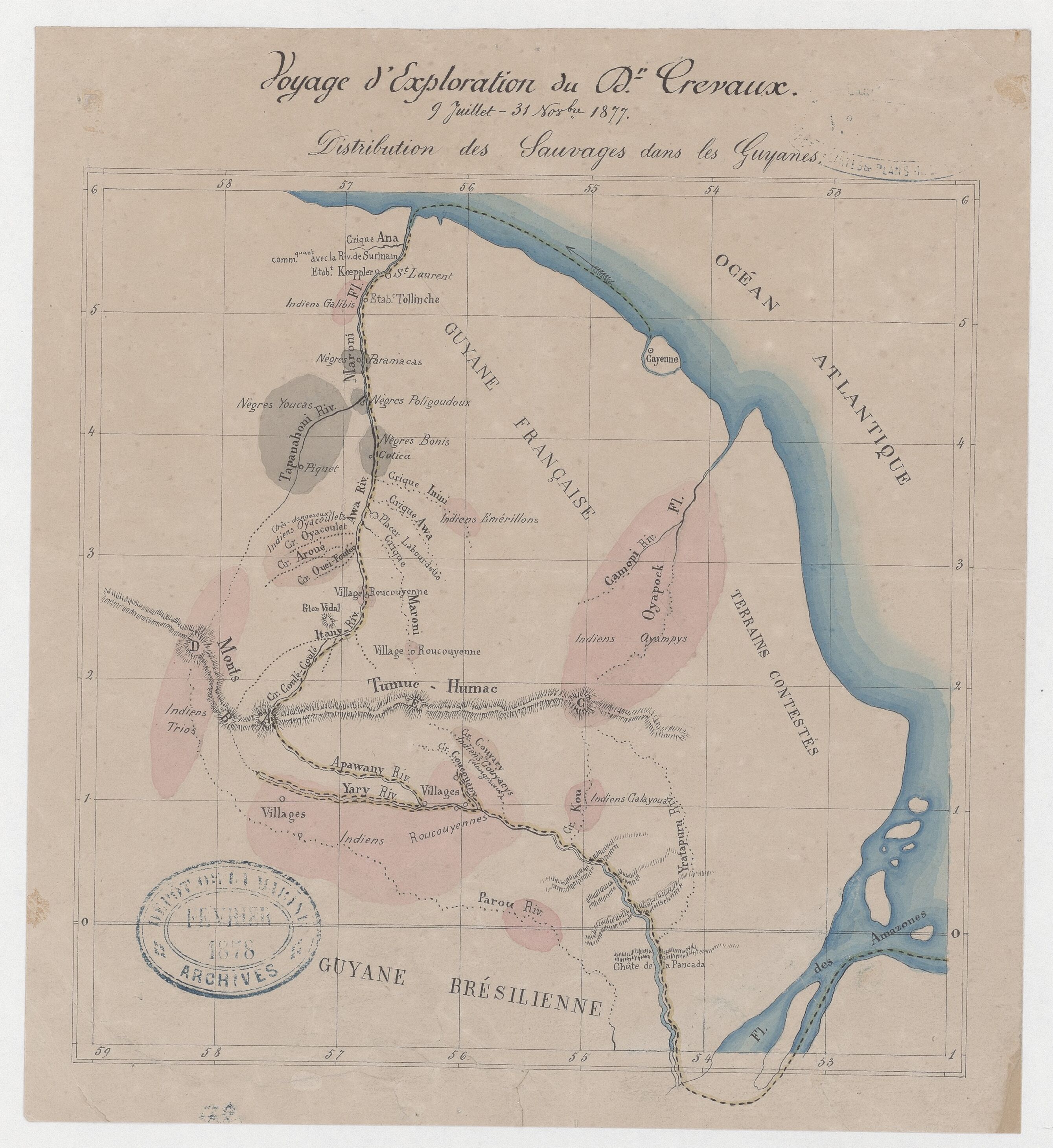
Dispossesions in the Americas

Dispossesions in the Americas

  • Home
  • Explore
  • About
  • Authors
  • Art
  • Bodies
  • Curricula
  • Cultural Heritage
  • Maps
  • Territories
Back to Explore
Map Commentary 1855 - 1877

Exploration Travels of Doctor Crevaux, July 9 – November 31, 1877.

  • Ardila Gutiérrez, Javier Ricardo

Published: 2024

  • Download Image
Voyage d'exploration du Docteur Crevaux, 9 juillet - 31 novembre 1877: distribution des sauvages dans les Guyanes / Jules Crevaux. Gallica. Last modified: January 29, 2018. Accessed, July 31, 2023.  https://gallica.bnf.fr/ark:/12148/btv1b531464634

Voyage d’exploration du Docteur Crevaux, 9 juillet - 31 novembre 1877: distribution des sauvages dans les Guyanes / Jules Crevaux. Gallica. Last modified: January 29, 2018. Accessed, July 31, 2023. https://gallica.bnf.fr/ark:/12148/btv1b531464634

Abstract

A new wave of interest in Guiana’s territory and inhabitants began in the second half of the nineteenth. At this time, two explorers visited the territory: Jules Crevaux (1847-1883) and Henri Coudreau (1859-1899). Both navigated the river Maroni, which marked the limits with Surinam. While Crevaux continued by the Jari, Coudreau went down through the Oyapock, by the current limits with Brazil.1 From these expeditions resulted in two books: Voyages dans l’Amérique du Sud (1883) and Chez nos Indians (1893), respectively*.* The map of the Crevaux depicts his journey from Cayenne through the Maroni River to the Amazon River’s opening and the Indigenous people he encountered during his expeditions.

Several explorations aimed to describe and understand the characteristics of the colonial world in the late nineteenth century. One strong motivation was to clearly define the boundaries between the colonial powers (in the case of French Guiana, with Suriname and with the Kingdom of Brazil).2 Other reasons stemmed from the ethnographic perspective of European colonialists.3 Material incentives also played a role, with the French Government turning its attention to Guiana following the discovery of gold deposits in the high Oyapock River and the Approuague River in 1855, areas traditionally inhabited by the Wayapi People.4

The map results from Crevaux’s first of three expeditions to South America between 1876 and 1883. In 1876, the Minister of Public Instruction commissioned him to explore the Maroni River. After falling sick of yellow fever in December 1876, he began the exploration of the river in July 1877 until April 1878, when he returned to France.5 One significant outcome of the exploration was a more concrete identification of Indigenous people, families, and groups who have been largely unknown since the first contact between Amerindians and Europeans.6 The map includes the location of eight Indigenous groups, some of which had already appeared in previous representations, such as the Emérillons, Galibis, Oyampys, Roucouyennes, and Trios. However, Crevaux also depicted some communities for the first time, like the Calayoua, the Couyarys, and the Oyacoulet. He noted that the last two were “very dangerous.” Instead of generalizing about the Indigenous people, Crevaux aimed to gain a deeper understanding of each community. Additionally, he wrote a book on the grammar of the Roucouyennes, Arrouague, and Piapoco languages. 7

This map also represents Afro descendant communities who lived autonomously on the margins of the Maroni River and its tributaries. Crevaux identified four groups: Bonis (Aluku), Paramacas (Paramaka), Poligoudoux, and Youcas (Djouka).8 It is important to note that the recognition of these communities went through several stages with the Dutch Government, and their protection by the French Government was crucial in demarcating the boundaries between French Guiana and Suriname.9 Crevaux passed away in April 1883 in Bolivia during his third journey to South America.

Map citation

Crevaux, Jules. Voyage d’exploration du Docteur Crevaux, 9 juillet - 31 novembre 1877: distribution des sauvages dans les Guyanes. Map. Paris, 1877. Bibliothèque National de France. – Gallica. Accessed August 12, 2024. https://gallica.bnf.fr/ark:/12148/btv1b531464634


  1. François-Michel Le Tourneau and Anna Greissing, “Crevaux et Coudreau, arpenteurs des Tumuc Humac,” Le Jari. Géohistoire d’un grand fleuve amazonien (Rennes: Presses universitaires de Rennes, 2013), paragraph 27. DOI: https://doi.org/10.4000/books.pur.47984. ↩︎

  2. Le Tourneau and Greissing, “Crevaux et Coudreau,” paragraph 5. ↩︎

  3. A seminal discussion on the unequal relationship between anthropological view and non-Western communities appears in Diane Lewis, “Anthropology and Colonialism,” Current Anthropology, 14, 5 (1973): 581-602. ↩︎

  4. Serge Mam-Lam-Fouck and Apollinaire Anakesa-Kululuka, Nouvelle histoire de la Guyane Française: des souverainetés amérindiennes aux mutations de la société (Matoury, Guyane: Ibis rouge, 2013), 90. ↩︎

  5. Jules Crevaux, Voyage dans la Guyane et le bassin de l’Amazone, conférence faite à la Société de géographie de l’Est (Nancy: Impr. de Berger-Levrault, 1880), pp. 3-26. Bibliothèque National de France – Gallica. Accessed September 16, 2024. https://gallica.bnf.fr/ark:/12148/bpt6k5624539t ↩︎

  6. Francis Dupuy, “Deux explorateurs dans l’intérieur de la Guyane à la fin du XIXe siècle : Jules Crevaux et Henri Coudreau” in Explorations et voyages scientifiques de l’Antiquité à nos jours, directed by Christiane Demeulenaere-Douyère (Paris: CTHS, 2008) 159-181. ↩︎

  7. Jules Crevaux, P. Sagot, Lucien Adam, Grammaires et vocabulaires roucouyenne, arrouague, piapoco et d’autres langues de la région des Guyanes (Paris: Maisonneuve, 1882) ↩︎

  8. About the current location of these groups, see: Richard Price and Sally Price, “The Arrivals of Marron in Guyane,” in Maroons in Guyane: Past, Present, Future (Athens: University of Georgia Press, 2022). ↩︎

  9. Le Tourneau and Greissing, “Crevaux et Coudreau,” 5. Mam-Lam-Fouck and Anakesa-Kululuka, Nouvelle Histoire De La Guyane Française, 24. ↩︎

Citation

Ardila Gutiérrez, Javier Ricardo. 2024. 'Exploration Travels of Doctor Crevaux, July 9 – November 31, 1877.'. Dispossessions in the Americas. https://staging.dia.upenn.edu/en/content/FGU0066Y/

  • Download Image

Reading in Spanish

Map Commentary 1855 - 1877

Viajes de exploración del doctor Crevaux, 9 de julio – 31 de noviembre de 1877. París, 1877

  • Ardila Gutiérrez, Javier Ricardo

Published: 2024

  • Download Image
Voyage d'exploration du Docteur Crevaux, 9 juillet - 31 novembre 1877: distribution des sauvages dans les Guyanes / Jules Crevaux. Gallica. Last modified: January 29, 2018. Accessed, July 31, 2023.  https://gallica.bnf.fr/ark:/12148/btv1b531464634

Voyage d’exploration du Docteur Crevaux, 9 juillet - 31 novembre 1877: distribution des sauvages dans les Guyanes / Jules Crevaux. Gallica. Last modified: January 29, 2018. Accessed, July 31, 2023. https://gallica.bnf.fr/ark:/12148/btv1b531464634

  • Download Image

Reading in Portuguese

Map Commentary 1855 - 1877

Viagens de exploração do doutor Crevaux, 9 de julho – 31 de novembro de 1877

  • Ardila Gutiérrez, Javier Ricardo

Published: 2024

FGU0066Y

Viagens de exploração do doutor Crevaux, 9 de julho – 31 de novembro de 1877. Paris, 1877

Comentário do mapa por Javier R. Ardila

Jules Crevaux, Viagem de exploração do Doutor Crevaux, 9 de julho - 31 de novembro de 1877: distribuição dos selvagens nas Guianas. Fonte: Biblioteca Nacional de Francia. Gallica. Digitalização (2018).

O interesse pelo território e pelos habitantes da Guiana aumento na segunda metade do século XIX. Neste período, dois célebres exploradores franceses visitaram a região: Jules Crevaux (1847-1883) e Henri Coudreau (1859-1899). Ambos navegaram pelo rio Maroni, que marca o limite com o Suriname. Enquanto Crevaux seguiu pelo rio Jari, Coudreau desceu pelo rio Oiapoque, nas atuais divisas com o Brasil. 1 Dessas expedições saíram os livros Voyages dans l’Amérique du Sud (1883) e Chez nos Indiens (1893), respectivamente. O mapa de Crevaux descreve seu itinerário desde Caiena através do rio Maroni, até a desembocadura do Amazonas, e os povos indígenas que encontrou durante suas travessias.

[LEIA MAIS]

Várias explorações buscaram descrever e compreender as características do mundo colonial ao final do século XIX. Uma motivação importante foi definir com maior clareza as fronteiras entre as potências coloniais (no caso da Guiana Francesa com o Suriname e o Reino do Brasil). 2 Outras razões derivaram da perspectiva etnográfica dos colonialistas europeus. 3 Os incentivos materiais também tiveram um papel importante, já que o governo francês renovou sua atenção para a Guiana após a descoberta de jazidas de ouro nas regiões altas dos rios Oiapoque e Aperuaque em 1855, áreas habitadas tradicionalmente pelo povo Wayapi. 4

Esse mapa é o resultado da primeira das três expedições de Crevaux pela América do Sul, entre 1876 e 1883. Em 1876, o ministro da Instrução Pública da França o encarregou para explorar o rio Maroni. Depois de ter febre amarela em dezembro de 1876, começou a exploração do rio em julho de 1877. A expedição durou até abril de 1878, quando retornou à França.5 Um dos resultados mais significativos da exploração foi a identificação de povos indígenas, famílias e grupo que haviam sido, em grande medida, desconhecidos desde o primeiro contato entre ameríndios e europeus. 6 O mapa de Crevaux inclui a localização de oito grupos indígenas, alguns dos quais já haviam aparecido em representações anteriores, como os Emérillons, Galibis, Oyampys, Roucouyennes (Wayanas/Uaianas) e Trios (Tiriyó). No entanto, Crevaux também apresentou pela primeira vez outras comunidades, como os Calayoua (Calaiúa), os Couyarys e os Oyacoulet. O viajante fez questão de assinalar que os dois últimos eram “muito perigosos”. Ao invés de generalizar, Crevaux buscou estudar cada comunidade em particular, o que se confirma em seu livro sobre a gramática das línguas Roucouyenne, Arrouague e Piapoco.7

O mapa também localiza as comunidades afrodescendentes que viviam de maneira autônoma nas margens do rio Maroni e seus afluentes. Crevaux identificou quatro grupos: Bonis (Aluku), Paramacas (Paramaka), Poligoudoux e Youcas (Djouka). 8 É importante destacar que o reconhecimento dessas comunidades passou por várias etapas. A proteção por parte do governo francês foi uma estratégia política crucial para demarcar as fronteiras entre a Guiana Francesa e o Suriname, sob o controle do governo holandês. 9 Crevaux faleceu em abril de 1883, na Bolívia, durante sua terceira viagem pela América do Sul.

Referência do mapa

Crevaux, Jules. Voyage d’exploration du Docteur Crevaux, 9 juillet - 31 novembre 1877: distribution des sauvages dans les Guyanes. Mapa. París, 1877. Bibliothèque National de France – Gallica. Acesso em : 12 de agosto de 2024. [https://gallica.bnf.fr/ark:/12148/btv1b531464634](https://gallica.bnf.fr/ark:/12148/btv1b531464634).


  1. François-Michel Le Tourneau and Anna Greissing, “Crevaux et Coudreau, arpenteurs des Tumuc Humac,” Le Jari. Géohistoire d’un grand fleuve amazonien (Rennes: Presses universitaires de Rennes, 2013), parágrafo 27. DOI: https://doi.org/10.4000/books.pur.47984. ↩︎

  2. Le Tourneau and Greissing, “Crevaux et Coudreau,” parágrafo 5. ↩︎

  3. Un debate pionero sobre la relación desigual entre la visión antropológica y las comunidades no occidentales aparece en Diane Lewis, “Anthropology and Colonialism,” Current Anthropology, 14, 5 (1973): 581-602. ↩︎

  4. Serge Mam-Lam-Fouck y Apollinaire Anakesa-Kululuka, Nouvelle histoire de la Guyane Française: des souverainetés amérindiennes aux mutations de la société (Matoury, Guayana: Ibis rouge, 2013), 90. ↩︎

  5. Jules Crevaux, Voyage dans la Guyane et le bassin de l’Amazone, conférence faite à la Société de géographie de l’Est (Nancy: Impr. de Berger-Levrault, 1880), pp. 3-26. Bibliothèque National de France – Gallica. Accesso em : 16 de setembro de 2024. https://gallica.bnf.fr/ark:/12148/bpt6k5624539t ↩︎

  6. Francis Dupuy, “Deux explorateurs dans l’intérieur de la Guyane à la fin du XIXe siècle : Jules Crevaux et Henri Coudreau” in Explorations et voyages scientifiques de l’Antiquité à nos jours, directed by Christiane Demeulenaere-Douyère (Paris: CTHS, 2008) 159-181. ↩︎

  7. Jules Crevaux, P. Sagot, Lucien Adam, Grammaires et vocabulaires roucouyenne, arrouague, piapoco et d’autres langues de la région des Guyanes (Paris: Maisonneuve, 1882) ↩︎

  8. Sobre a localização atal dessas comunidades, veja o trabalho de Richard Price y Sally Price, “The Arrivals of Marron in Guyane,” em Maroons in Guyane: Past, Present, Future (Athens: Editora da Universidade de Georgia, 2022). ↩︎

  9. Le Tourneau y Greissing, “Crevaux et Coudreau,” 5. Mam-Lam-Fouck and Anakesa-Kululuka, Nouvelle Histoire De La Guyane Française, 24. ↩︎

Citation

Ardila Gutiérrez, Javier Ricardo. 2024. 'Viagens de exploração do doutor Crevaux, 9 de julho – 31 de novembro de 1877'. Dispossessions in the Americas. https://staging.dia.upenn.edu/pt/content/FGU0066Y/

Related Content

Voyage d'exploration du Docteur Crevaux, 9 juillet - 31 novembre 1877 : distribution des sauvages dans les Guyanes.

Voyage d'exploration du Docteur Crevaux, 9 juillet - 31 novembre 1877 : distribution des sauvages dans les Guyanes.

Map 1877

Dispossessions in the Americas

A project by

University of Pennsylvania

Copyright 2024

With support from

Mellon Foundation

Site design & development

Element 84

Art Credits

Voyage d’exploration du Docteur Crevaux, 9 juillet - 31 novembre 1877: distribution des sauvages dans les Guyanes / Jules Crevaux. Gallica. Last modified: January 29, 2018. Accessed, July 31, 2023. https://gallica.bnf.fr/ark:/12148/btv1b531464634

Site Pages

  • Home
  • Explore
  • About
  • Authors
  • Art
  • Bodies
  • Curricula
  • Cultural Heritage
  • Maps
  • Territories