Dispossesions in the Americas

Dispossesions in the Americas

  • Home
  • Explore
  • About
  • Authors
  • Art
  • Bodies
  • Curricula
  • Cultural Heritage
  • Maps
  • Territories
Back to Explore
Map Commentary 1900

THE KARANQAS AYMARA POLITY - SNAPSHOT OF TRANS-BORDER CONNECTIONS AROUND 1900 (GOOGLE EARTH ADAPTATION)

  • Medeiros, Carmen

  • Grisi, Celina

  • Sánchez Patzy, Radek

Published: 2024

  • Download Image
Cottyn, H. (2021) Carangas en movimiento: estado liberal, elites provinciales y movilidad trans-fronteriza andina entre el Altiplano boliviano y el Pacífico (1860-1930). Diálogo Andino, 66, pp. 261-272.

Cottyn, H. (2021) Carangas en movimiento: estado liberal, elites provinciales y movilidad trans-fronteriza andina entre el Altiplano boliviano y el Pacífico (1860-1930). Diálogo Andino, 66, pp. 261-272.

Abstract

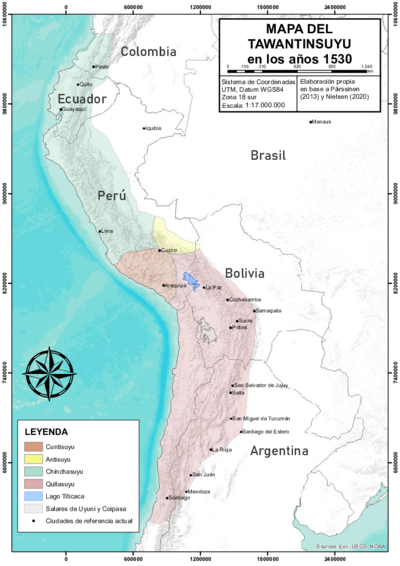
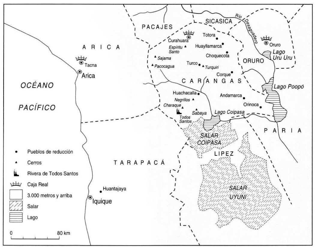
The map shows the changes and continuities in the cross-border mobility of the Aymara polity of the Karanqas Carangas) in the context of 19th century state formation and commercial expansion.1 Before the arrival of Spanish colonizers, in the 16th century, the Aymara polity of the Karanqas was part of the Qullasuyu, the southern district of the Inca state Tawantinsuyu. Following the model of ‘vertical control of ecological niches’ AYMARA POLITIES of THE QULLASUYU in the 16th CENTURY the territory of the Karanqas was located in the central western part of the high plateau yet it included ‘ethnic islands’ in the valleys west and east. After Bolivia and Chile established themselves as independent republics in the 19th century, the territory was divided between the two nations. Despite this division, Karanqas trans-border connections persisted and continue to exist today. The map, which is drawn upon a modern Google Earth image, shows the main Karanqas’ towns near the border with Chile and Perú, as well as the main towns that were part of the Karanqas’ route towards the Pacific (both towards Arica and Tacna as well as towards Iquique in present-day Chile) in the 19th century.

This map is noteworthy for its ability to capture the enduring trans-border nature of the Karanqas, persisting beyond the independence of Peru, Chile, and Bolivia, amidst the fluctuating dynamics influenced by events like the Pacific War. To some extent, these changes left the Karanqas isolated from the rest of the Bolivian Republic; however, their connection to the communities to the west remained being very important. Communities on both sides of these international borders sought to assert and accommodate their control over their grasslands, farmlands, and mines within the new national territorial boundaries2. The active commerce they maintained with each other was part of their strategy to respond to the changes.

The trans-cordilleran territories were especially relevant for the Karanqa, partly because of the ecological characteristics of the region which were those of a cold and dry climate. In fact, the altiplano and the western valleys are very close and connected (often more accessible than the eastern valleys), allowing a fluid transit and control between the two mountain slopes. In addition to the fact that the valleys at this latitude extend to the coast, facilitating transit to the Pacific. 3

While some scholars argue that these trans-cordilleran territories were strategically employed by the Karankas Aymara polity THE KARANQAS AYMARA POLITY UNDER SPANISH COLONIAL RULE IN THE 18TH CENTURY to effectively respond and resist to colonial pressures, it has also been argued that the Karanqas nucleus saw its connection with the Pacific enclaves diminish as indigenous organizational structures underwent fragmentation during colonization. 4 Further research is needed to fully comprehend how the Karanqas utilized access to these territories as part of their resilience strategies during the Spanish colonization period. Nevertheless, despite numerous changes, trans-border networks remain integral to contemporary Karanqas life.

REFERENCES:

Cajías de la Vega, F. Oruro 1781, sublevación de indios y rebelión criolla: vol I. La Paz: IFEA, 2005.

Cottyn, Hanne. “Entre Comunidad Indígena y Estado Liberal: los ‘Vecinos’ de Carangas
(Siglos XIX-XX).” Boletín Americanista 2, no. 65 (2012): 39-59.

Cottyn, H. “Global land commodification, national land reform and communal land tenure in Carangas (Bolivia), 19th -20th centuries”. Paper presented at the Rural History conference, Bern, 2013.

Cottyn, Hanne. “Carangas en Movimiento: Estado Liberal, Elites Provinciales y
Movilidad Transfronteriza Andina entre el Altiplano Boliviano y el Pacífico
(1860-1930).” Diálogo Andino 66 (December 2021): 261-272.

Gavira-Marquez, M. C. “Población Indígena, Minería y Sublevación en Carangas: La Caja
Real de Carangas y el Mineral de Huantajaya, 1750-1804”, Lima: Instituto Francés
de Estudios Andinos - CIHDE, 2008.

Michel, M. “El Señorío Prehispánico de Carangas.” Thesis of the Advanced Diploma in
Indigenous Peoples’ Law, Universidad de la Cordillera, La Paz, 2000.

Montero Montero, R. Gil. “Migración y Minería en el Corregimiento de Carangas (actual Bolivia), Siglo XVII.” Anuario de Historia de América Latina 55 (2018): 190-217.


  1. Cottyn, Hanne. “Carangas en Movimiento: Estado Liberal, Elites Provinciales y Movilidad Trans- Fronteriza Andina entre el Altiplano Boliviano y el Pacífico (1860-1930).” Diálogo Andino 66 (December 2021): 261-272. ↩︎

  2. Cottyn. “Carangas en Movimiento, 264. ↩︎

  3. R. Gil Montero Montero, “Migración y minería en el corregimiento de Carangas (actual Bolivia), siglo XVII,” Anuario de Historia de América Latina 55 (2018): 190-217. ↩︎

  4. M. C. Gavira-Marquez, Población Indígena, Minería y Sublevación en Carangas: La Caja Real de Carangas y el Mineral de Huantajaya, 1750-1804 (Lima: Instituto Francés de Estudios Andinos – CIHDE, 2008), 9. ↩︎

Citation

Medeiros, Carmen, Celina Grisi, and Radek Sánchez Patzy. 2024. 'THE KARANQAS AYMARA POLITY - SNAPSHOT OF TRANS-BORDER CONNECTIONS AROUND 1900 (GOOGLE EARTH ADAPTATION)'. Dispossessions in the Americas. https://staging.dia.upenn.edu/en/content/BOL0041Y/

  • Download Image

Reading in Spanish

Map Commentary 1900

EL SISTEMA POLÍTICO KARANQAS AYMARA - INSTANTÁNEA DE LAS CONEXIONES TRANSFRONTERIZAS EN TORNO A 1900 (ADAPTACIÓN DE GOOGLE EARTH)

  • Medeiros, Carmen

  • Grisi, Celina

  • Sánchez Patzy, Radek

Published: 2024

  • Download Image
Cottyn, H. (2021) Carangas en movimiento: estado liberal, elites provinciales y movilidad trans-fronteriza andina entre el Altiplano boliviano y el Pacífico (1860-1930). Diálogo Andino, 66, pp. 261-272.

Cottyn, H. (2021) Carangas en movimiento: estado liberal, elites provinciales y movilidad trans-fronteriza andina entre el Altiplano boliviano y el Pacífico (1860-1930). Diálogo Andino, 66, pp. 261-272.

  • Download Image

Reading in Portuguese

Map Commentary 1900

O TERRITÓRIO AIMARÁ DOS KARANQAS - PANORAMA DAS CONEXÕES TRANSFRONTEIRIÇAS POR VOLTA DO ANO 1900 (ADAPTAÇÕES DO GOOGLE EARTH)

  • Medeiros, Carmen

  • Grisi, Celina

  • Sánchez Patzy, Radek

Published: 2024

  • Download Image
Cottyn, H. (2021) Carangas en movimiento: estado liberal, elites provinciales y movilidad trans-fronteriza andina entre el Altiplano boliviano y el Pacífico (1860-1930). Diálogo Andino, 66, pp. 261-272.

Cottyn, H. (2021) Carangas en movimiento: estado liberal, elites provinciales y movilidad trans-fronteriza andina entre el Altiplano boliviano y el Pacífico (1860-1930). Diálogo Andino, 66, pp. 261-272.

Resumo

O mapa mostra as mudanças e continuidades na mobilidade transfronteiriça do território aimará dos Karanqas (Carangas) no contexto da formação do Estado e da expansão comercial no século XIX.1 Antes da chegada dos colonizadores espanhóis, no século XVI, o território aimará dos Karanqas fazia parte de Qullasuyu, o distrito sul do estado Inca Tawantinsuyu. Seguindo o modelo de “controle vertical de nichos ecológicos” (/pt/content/BOL0002Y/), o território dos Karanqas localizava-se na parte centro-oeste do planalto, embora incluísse “ilhas étnicas” nos vales ocidentais e orientais. Após a Bolívia e o Chile se estabelecerem como repúblicas independentes no século XIX, o território foi dividido entre as duas nações. Apesar dessa divisão, as conexões transfronteiriças dos Karanqas persistiram e continuam a existir até hoje. O mapa, elaborado a partir de uma imagem moderna do Google Earth, mostra as principais cidades dos Karanqas próximas à fronteira com o Chile e o Peru, bem como as principais cidades que faziam parte da rota dos Karanqas em direção ao Pacífico (tanto em direção a Arica e Tacna quanto em direção a Iquique, no atual Chile) no século XIX.

Este mapa destaca-se pela sua capacidade de captar a duradoura natureza transfronteiriça dos Karanqas, que persistiu para além da independência do Peru, Chile e Bolívia, em meio à dinâmica instável influenciada por eventos como a Guerra do Pacífico. Em certa medida, essas mudanças deixaram os Karanqas isolados do resto da República Boliviana; no entanto, sua conexão com as comunidades do oeste permaneceu muito importante. Comunidades de ambos os lados dessas fronteiras internacionais buscaram afirmar e consolidar seu controle sobre suas pastagens, terras agrícolas e minas dentro dos novos limites territoriais nacionais.2 O comércio ativo que mantinham entre si fazia parte de sua estratégia para responder às mudanças.

Os territórios transcordilheiranos eram especialmente relevantes para os Karanqas, em parte devido às características ecológicas da região, caracterizadas por um clima frio e seco. Na verdade, o altiplano e os vales ocidentais são muito próximos e interligados (frequentemente mais acessíveis do que os vales orientais), permitindo um trânsito e controle fluidos entre as duas encostas. Além do fato de os vales nessa latitude se estenderem até a costa, facilitando o trânsito para o Pacífico. 3

Embora alguns estudiosos argumentem que esses territórios transcordilheiranos foram estrategicamente empregados pelo território aimará dos Karanqas O TERRITÓRIO AIMARÁ DE KARANQAS SOB O DOMÍNIO COLONIAL ESPANHOL NO SÉCULO XVIII para responder e resistir de maneira eficaz às pressões coloniais, também argumenta-se que o núcleo dos Karanqas viu sua conexão com os enclaves do Pacífico diminuir à medida que as estruturas organizacionais indígenas sofreram fragmentação durante a colonização. 4 São necessárias mais pesquisas para compreender plenamente como os Karanqas utilizaram o acesso a esses territórios como parte de suas estratégias de resiliência durante o período de colonização espanhola. Contudo, apesar das inúmeras mudanças, as redes transfronteiriças continuam sendo parte integrante da vida contemporânea dos Karanqas.

REFERÊNCIAS:

Cajías de la Vega, F. Oruro 1781, sublevación de indios y rebelión criolla: vol I. La Paz: IFEA, 2005.

Cottyn, Hanne. “Entre Comunidad Indígena y Estado Liberal: los ‘Vecinos’ de Carangas
(Siglos XIX-XX).” Boletín Americanista 2, no. 65 (2012): 39-59.

Cottyn, H. “Global land commodification, national land reform and communal land tenure in Carangas (Bolivia), 19th -20th centuries”. Artigo apresentado na Rural History Conference, Bern, 2013.

Cottyn, Hanne. “Carangas en Movimiento: Estado Liberal, Elites Provinciales y
Movilidad Transfronteriza Andina entre el Altiplano Boliviano y el Pacífico
(1860-1930).” Diálogo Andino 66 (Dezembro de 2021): 261-272.

Gavira-Marquez, M. C. “Población Indígena, Minería y Sublevación en Carangas: La Caja
Real de Carangas y el Mineral de Huantajaya, 1750-1804”, Lima: Instituto Francês
de Estudos Andinos - CIHDE, 2008.

Michel, M. “El Señorío Prehispánico de Carangas.” Dissertação de Diploma Avançado em Direito dos Povos Indígenas, Universidad de la Cordillera, La Paz, 2000.

Montero Montero, R. Gil. “Migración y Minería en el Corregimiento de Carangas (actual Bolivia), Siglo XVII.” Anuario de Historia de América Latina 55 (2018): 190-217.


  1. Cottyn, Hanne. “Carangas en Movimiento: Estado Liberal, Elites Provinciales y Movilidad Trans- Fronteriza Andina entre el Altiplano Boliviano y el Pacífico (1860-1930).” Diálogo Andino 66 (Dezembro de 2021): 261-272. ↩︎

  2. Cottyn. “Carangas en Movimiento, 264. ↩︎

  3. R. Gil Montero Montero, “Migración y minería en el corregimiento de Carangas (actual Bolivia), siglo XVII,” Anuario de Historia de América Latina 55 (2018): 190-217. ↩︎

  4. M. C. Gavira-Marquez, Población Indígena, Minería y Sublevación en Carangas: La Caja Real de Carangas y el Mineral de Huantajaya, 1750-1804 (Lima: Instituto Francês de Estudos Andinos – CIHDE, 2008), 9. ↩︎

Citation

Medeiros, Carmen, Celina Grisi, and Radek Sánchez Patzy. 2024. 'O TERRITÓRIO AIMARÁ DOS KARANQAS - PANORAMA DAS CONEXÕES TRANSFRONTEIRIÇAS POR VOLTA DO ANO 1900 (ADAPTAÇÕES DO GOOGLE EARTH)'. Dispossessions in the Americas. https://staging.dia.upenn.edu/pt/content/BOL0041Y/

  • Download Image

Related Content

AYMARA POLITIES of THE QULLASUYU in the 16th CENTURY

AYMARA POLITIES of THE QULLASUYU in the 16th CENTURY

Map Commentary 1530 - 1539
THE QULLASUYU IN THE 1530s – SOUTHERN DISTRICT OF THE INCA STATE

THE QULLASUYU IN THE 1530s – SOUTHERN DISTRICT OF THE INCA STATE

Map Commentary 1530 - 1539
THE TAWANTINSUYU IN THE 1530s – TERRITORY OF THE INCA STATE

THE TAWANTINSUYU IN THE 1530s – TERRITORY OF THE INCA STATE

Map Commentary 1530 - 1539
THE KARANQAS AYMARA POLITY UNDER SPANISH COLONIAL RULE IN THE 18TH CENTURY

THE KARANQAS AYMARA POLITY UNDER SPANISH COLONIAL RULE IN THE 18TH CENTURY

Map Commentary 1700 - 1799

Dispossessions in the Americas

A project by

University of Pennsylvania

Copyright 2024

With support from

Mellon Foundation

Site design & development

Element 84

Art Credits

Cottyn, H. (2021) Carangas en movimiento: estado liberal, elites provinciales y movilidad trans-fronteriza andina entre el Altiplano boliviano y el Pacífico (1860-1930). Diálogo Andino, 66, pp. 261-272.

Site Pages

  • Home
  • Explore
  • About
  • Authors
  • Art
  • Bodies
  • Curricula
  • Cultural Heritage
  • Maps
  • Territories