Dispossesions in the Americas

Dispossesions in the Americas

  • Home
  • Explore
  • About
  • Authors
  • Art
  • Bodies
  • Curricula
  • Cultural Heritage
  • Maps
  • Territories
Back to Explore
Map Commentary 1500 - 1550

AYMARA LORDSHIPS OF THE CHARKA AND NEIGHBORING NON-AYMARA POLITIES IN THE LATE 15th AND EARLY 16th CENTURIES

  • Medeiros, Carmen

  • Grisi, Celina

  • Sánchez Patzy, Radek

Published: 2024

  • Download Image
Platt, T., Bouysse-Cassagne, T., & Harris, O. (2006). Qaraqara-Charka: Mallku, Inka y rey en la Provincia de Charcas (siglos XV – XVII): Historia antropológica de una confederación aymara. Edicion documental y ensayos interpretativos. Con el aliento de Thierry Saignes. Instituto Frances de Estudios Andinos, Plural Editores, Fundacion Cultural del Banco Central de Bolivia, University of St. Andrews.

Platt, T., Bouysse-Cassagne, T., & Harris, O. (2006). Qaraqara-Charka: Mallku, Inka y rey en la Provincia de Charcas (siglos XV – XVII): Historia antropológica de una confederación aymara. Edicion documental y ensayos interpretativos. Con el aliento de Thierry Saignes. Instituto Frances de Estudios Andinos, Plural Editores, Fundacion Cultural del Banco Central de Bolivia, University of St. Andrews.

Abstract

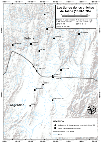
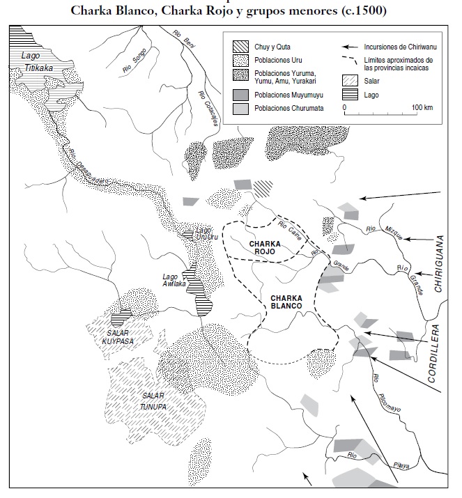
This map focuses on the southeastern region of present-day Bolivia. It displays the location of the territories of the Aymara lordships of the Charka (Red Charka) and the White Charka peoples—which would later become the Qaraqara-Charka federation—, as well as the location of the non-Aymara groups around them, at the end of the 15th century. The map is a snapshot of the time when this region of the Qullasuyu was already part of the Inca state, the Tawantinsuyu, just before the reorganization carried out by Inca Wayna Qhapaq in the first decades of the 16th century. The map also shows the points through which peoples from the low-altitude areas —known as Chiriguanos, nowadays Guaraníes— carried out raids and incursions into the Charka space, originating from the east and the south regions.1

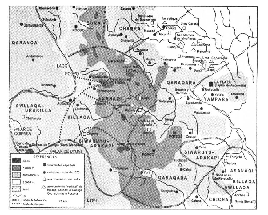
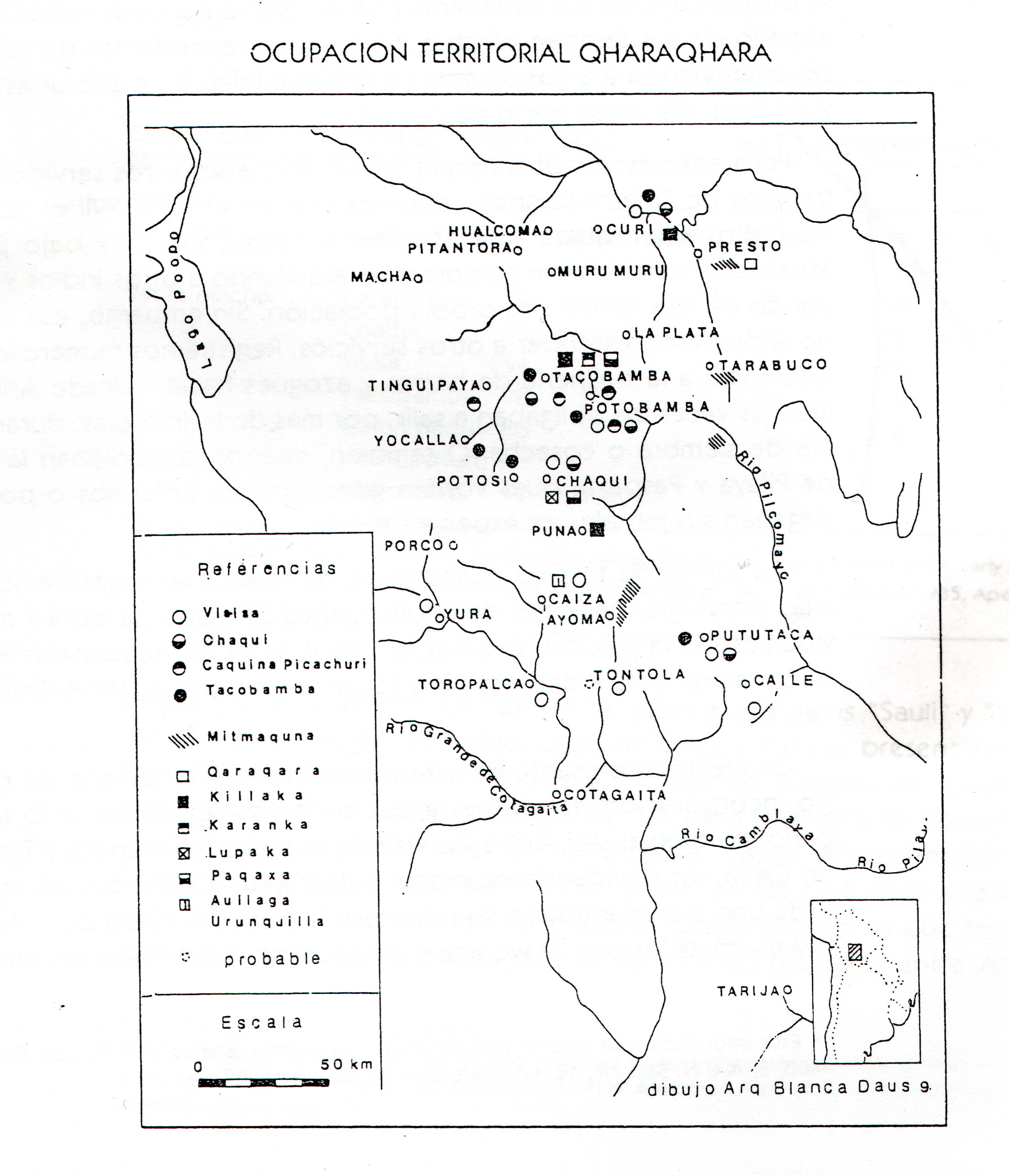
Based on ethnohistoric and anthropological research, the map suggests the mono-ethnicity of the socio-political units of the Charka peoples —also called Charkas and Charcas—, established before the Wayna Qhapaq government. The two major partitions running as an ancient dual Confederation of the Charkas; namely, the White Charkas (Urqu section) and the Red Charkas (Uma section) seem to have split during the government of Wayna Qhapaq. More specifically, the White Charkas constituted the Qaraqaras sociopolitical unit, whereas the Red Charkas became the Charkas separate political entity.2 When the Spaniards arrived in the 1530s, they found two Aymara lordships functioning as a Qaraqara-Charka confederation. This alliance was linked to six other “nations”, south of the Lake Titicaca region known as Collao. Namely, Qaraqara, Sura,Chuy, Killaka, Karanqas, Chichas.

The territorial presence of the Aymara lordship AYMARA POLITIES of THE QULLASUYU in the 16th CENTURY called Charka, a dispersed and non-contiguous territory, was located in the current northwest of the department of Chuquisaca, north of the department of Potosí, center-south and extreme east of the department of Cochabamba.

The colonial territorial-population units (or repartimientos) to which the Charka were assigned around 1550 are the repartimientos of Sacaca, Chayanta —its main centers— and Cochabamba.3 During the early colonial period, the word “Charcas” was extended to all the territories placed under the jurisdiction of the Audiencia de La Plata, the so-called “Audiencia de Charcas,” founded in 1559 with its capital in La Plata. According to its meaning, the word “Charcas” refers to all those “provinces” and “nations” located south of the Collao, and right before reaching the greater Tucumán region, in what is today known as Argentina´s northwest.

With the new system imposed by the Europeans, the first administrative units around which they tried to organize the region´s Indigenous societies were the repartimientos and the encomiendas. In the corregimiento (province) of Chayanta, —administrative head of the Charka—, the repartimientos respected the system of authorities within the Charkas and Qaraqaras. Thus, the repartimiento of Chayanta —which had more people than Macha and had been previously dispersed in 134 villages—, was resettled in three reduction villages COLONIAL LEGISLATIONS AS FRAMEWORK FOR DISPOSSESSIONS IN THE CENTRAL ANDES: THE “REDUCCIONES” OR “PUEBLOS REALES DE INDIOS” , whereas Macha *—*with a smaller population and previously established in 106 villages—, was resettled in four units.4 The reductions were not implemented on the basis of individuals, but of ayllus, the basic nucleus of family-based territorial organization in the Andes, as part of a population and territorial concentration policy that would breed new collective identities and alterations in the settlements´ hierarchies. The structuring of the territories was adjusted to the features of a population with discontinuous settlement patterns, although these may differ from those in pre-Hispanic times.

The province of Chayanta had five divisions recognized by Viceroy Toledo that maintained their ethnic affiliation. The ayllus had to coexist within the colonial towns, especially in the valley zone where the “archipelago” formation was heightened. Even so, ethnic identities were maintained by assigning “streets” to each ayllu, which served as territorial borders or boundary markers.5

In the period between the foundation of the Republic, in 1825, and the years prior to the Pacific War (1879-1883), land control in the altiplano and valley regions allowed family subsistence to be minimally secured within the same province, and served in turn as a basis for the creation of marketable surpluses on community lands. The administration of the production and commercialization of wheat and corn was left to the ayllus´ Indigenous authorities, who were able to generate surpluses to comply with their payment obligations of the Indigenous tribute COLONIAL LEGISLATION AS FRAMEWORK FOR DISPOSSESSIONS IN THE CENTRAL ANDES: THE INDIGENOUS TRIBUTE, 1730s - 1820s still in force and perceived by the ayllus as a “reciprocity pact” that guaranteed their safe access to the lands.6 However, the republican state preferred to emphasize that the ayllus were simple beneficiaries of the state lands and that the tribute was a simple lease paid to the state as the sole owner of all lands.7 As a consequence, customs barriers were removed, and the state monopoly on the purchase of silver paste was annulled. In turn, the railroad directed its railway lines towards export points to the detriment of inner road integration, which resulted in a domestic market crisis. This liberal program had its repercussions in the wheat production crisis in the Charka region, and in the second boom of silver mining for export in Colquechaca. During the 19th century, the mestizos and the regional Creole elites once again monopolized the position as tribute collectors for the ayllus and subdivisions in the region until the Federal War of 1899.

The application of liberal policies left open a legal pathway that would “justify” the forced selling of land imposed on communities in some regions. The Land Alienation Laws imposed from the 1870s onwards gave rise to a “paternal generosity” stance by seeking the expiration of ayllu as collective property in favor of individual tenure and private property, considered a sign of “modernity and progress.” These laws, which in many areas generated the conversion of the communal Indian into colonist, tenant farmer and small landowner, did not have the same effect on the ayllus that belonged to the Qaraqara-Charka confederation. In Charka, they continued to have possession over their territories with their main centers in the altiplano and their “islands” in the valleys, in line with the system of vertical control of the ecological niches. Faced with the threat of expropriation of their own lands, the mestizo neighbors of the towns allied with the ayllus, and the hacienda owners failed to obtain the power they yielded in La Paz.

On their part, the authorities of Potosí and its provinces did not agree with a tax reform that would take away the main income in the departmental coffers in exchange for an uncertain “cadastral tax”, stipulated in the Land Alienation Act of 1874, which even the landowners were unwilling to pay.8 In order to pay the tax, a periodic readjustment of the amount budgeted for each province was required. It was necessary to carry out “revisitas”, where the names of the taxpayers and their families were recorded, as well as details of the land they occupied and the tax category to which they belonged. This generated a sort of “fiscal lawlessness” by which the government authorities tried to expand their income sources at the expense of the traditional jurisdiction of the Indigenous authorities.9

One of the effects of the Land Reform of 1953 was the legalization of land on an individual basis, since the Law did not recognize collective tenure, which led to a process of unionization of peasant organizations. However, the ayllus, with records and documentation from colonial times, maintained their collective lands and based on this form of organization, sought to legalize their territory according to the available legislation. The case of the ayllu Chayantaka, in the municipality of Chayanta, former head of Charka, is paradigmatic of the situation of the Charka ayllus today. Chayantaka demanded the endowment and “recovery” of dispersed and discontinuous territories in their ancestral ecological valley niche, but the loss of real ties and the gradual fragmentation processes that ensued since 1570 led to the abdication of this territory, which remains in the ancient memory of the original Chayantaka inhabitants, since there is still a cultural identity bond with this region. Thus, it was not possible to consolidate the discontinuous territoriality, an Andean original trait that the colonial and republican state managed to dispossess.

REFERENCES:

Adrián, Mónica. “Acerca de las unidades de análisis en el sur andino colonial a partir
de un estudio de caso: Chayanta, siglo XVI– siglo XVIII”. Surandino Monográfico, 2-2 (2012), 1-31.

Calizaya Velásquez, Oscar. “Estudio de Caso Nº 1. Chayantaka, el Ayllu con Gestión Territorial Indigena: Territorio Originario en Potosí”. En Territorios Indígena Originario Campesinos en Bolivia: Entre la Loma Santa y la Pachamama. Informe 2010, edited by Fundación Tierra, 233- 263. La Paz: Fundación Tierra, 2011.

Platt, Tristan, Thérèse Bouysse-Cassagne, and Olivia Harris. Qaraqara-Charka: Mallku, Inka y Rey en la Provincia de Charcas (siglos XV - XVII): Historia Antropológica de una Confederación Aymara (Qaraqara-Charka: Mallku, Inka y Rey en la Provincia de Charcas (siglos XV - XVII): Historia Antropológica de una Confederación Aymara). La Paz: Plural-IFEA, 2006.

Platt, Tristan Estado Boliviano y Ayllu Andino: Tierra y Tributo en el Norte de Potosí (2nd ed.). La Paz, Bolivia: Biblioteca del Bicentenario de Bolivia, 2016.

Rivera, Silvia. “Estado Boliviano y Ayllu Andino, 30 Años Después” [Introductory Study], 15-34. In Estado Boliviano y Ayllu Andino. Tierra y Tributo en el Norte de Potosí, Tristan Platt, 15-34. La Paz: Bicentennial Library of Bolivia, 2016.


  1. Tristan Platt, Thérèse Bouysse-Cassagne and Olivia Harris. Qaraqara-Charka: Mallku, Inka y Rey en la Provincia de Charcas (siglos XV - XVII): Historia Antropológica de una Confederación Aymara (La Paz: Plural-IFEA, 2006), 57. ↩︎

  2. Platt, Bouysse-Cassagne and Harris*. Qaraqara-Charka,* 46. ↩︎

  3. Mónica Adrián, “Acerca de las Unidades de Análisis en el Sur Andino Colonial a partir de un Estudio de Caso: Chayanta, Siglo XVI- Siglo XVIII”. Surandino Monográfico, 2-2 (2012): 1-31. ↩︎

  4. Adrián, “Acerca de las Unidades de Análisis en el Sur Andino Colonial a partir de un Estudio de Caso”. ↩︎

  5. Platt, Bouysse-Cassagne and Harris. Qaraqara-Charka: Mallku, Inka and King in the Province of Charcas (15th - 17th centuries), 71. ↩︎

  6. Tristan Platt, Estado Boliviano y Ayllu Andino: Tierra y Tributo en el Norte de Potosí (2nd ed.) (La Paz: Biblioteca del Bicentenario de Bolivia, 2016). ↩︎

  7. Platt. Estado Boliviano y Ayllu Andino: Tierra y Tributo en el Norte de Potosí ↩︎

  8. Silvia Rivera, “Estado Boliviano y Ayllu Andino, 30 Años Después” [Introductory Study], 15-34. In Bolivian State and Andean Ayllu. Land and Tribute in Northern Potosí, Tristan Platt, 15-34. (La Paz: Bicentennial Library of Bolivia), 2016. ↩︎

  9. Platt, Estado Boliviano y Ayllu Andino. Tierra y Tributo en el Norte de Potosí. ↩︎

Citation

Medeiros, Carmen, Celina Grisi, and Radek Sánchez Patzy. 2024. 'AYMARA LORDSHIPS OF THE CHARKA AND NEIGHBORING NON-AYMARA POLITIES IN THE LATE 15th AND EARLY 16th CENTURIES'. Dispossessions in the Americas. https://staging.dia.upenn.edu/en/content/BOL0036Y/

  • Download Image

Reading in Spanish

Map Commentary 1500 - 1550

SEÑORÍOS AYMARAS DE LOS CHARKA Y ENTIDADES POLÍTICAS VECINAS NO AYMARAS, A FINALES DEL SIGLO XV Y PRINCIPIOS DEL SIGLO XVI

  • Medeiros, Carmen

  • Grisi, Celina

  • Sánchez Patzy, Radek

Published: 2024

  • Download Image
Platt, T., Bouysse-Cassagne, T., & Harris, O. (2006). Qaraqara-Charka: Mallku, Inka y rey en la Provincia de Charcas (siglos XV – XVII): Historia antropológica de una confederación aymara. Edicion documental y ensayos interpretativos. Con el aliento de Thierry Saignes. Instituto Frances de Estudios Andinos, Plural Editores, Fundacion Cultural del Banco Central de Bolivia, University of St. Andrews.

Platt, T., Bouysse-Cassagne, T., & Harris, O. (2006). Qaraqara-Charka: Mallku, Inka y rey en la Provincia de Charcas (siglos XV – XVII): Historia antropológica de una confederación aymara. Edicion documental y ensayos interpretativos. Con el aliento de Thierry Saignes. Instituto Frances de Estudios Andinos, Plural Editores, Fundacion Cultural del Banco Central de Bolivia, University of St. Andrews.

  • Download Image

Reading in Portuguese

Map Commentary 1500 - 1550

SENHORIO AIMARÁS DOS CHARKA E ENTIDADES POLÍTICAS VIZINHAS NÃO AIMARÁS, FINAL DO SÉCULO XV E COMEÇO DO SÉCULO XVI

  • Medeiros, Carmen

  • Grisi, Celina

  • Sánchez Patzy, Radek

Published: 2024

BOL0036Y: No image found

BOL0036Y

SENHORIO AIMARÁS DOS CHARKA E ENTIDADES POLÍTICAS VIZINHAS NÃO AIMARÁS, FINAL DO SÉCULO XV E COMEÇO DO SÉCULO XVI

Carmen Medeiros, Celina Grisi y Radek Sánchez

[XXX insert map BOL0036 with title and reference_nt as caption]

Este mapa tem como foco a região sudeste da atual Bolívia, mostrando a localização dos territórios dos senhorios aimarás [XXX link to BOL0003Y] do Charka (Charka Vermelho) e do Charka branco, que mais tarde formariam a federação Qaraqara-Charka, assim como a localização dos grupos não-aimarás no seu entorno, ao final do século XV. Ou seja, o mapa faz um recorte do momento em que esta região do Qullasuyu [XXX link to BOL0002Y] já era parte do estado Inca, el Tawantinsuyu [XXX link to BOL0001Y], mas antes da reorganização implementada pelo Inca Wayna Qhapaq nas primeiras décadas do século XVI. O mapa também mostra os pontos pelos quais ocorreram as incursões de povos de terras baixas (os denominados Chiriguanos, hoje guaranis) no território Charka, pelo leste e pelo sul1. [LEIA MAIS]

Com base em pesquisas etno-históricas e antropológicas, o mapa sugere a monoetnicidade das unidades sociopolíticas do Charka [também chamados Charkas e Charcas], que teriam sido construídas antes do governo Wayna Qhapaq. As duas parcialidades maiores do que teria sido uma antiga confederação dupla dos Charkas: Charkas brancos (parcialidade Urqu) e Charkas Vermelhos (parcialidade Uma). Seria então durante o governo de Wayna Qhapaq que se produziu uma diferenciação entre a parcialidade dos Charkas Brancos, que teriam passado a se constituir como unidade sociopolítica dos Qaraqaras, e a parcialidade dos Charkas vermelhos, que permaneceu sendo os Charkas.2 Quando chegaram os espanhóis, na década de 1530, já eram dois senhorios aimarás que funcionavam como confederação Qaraqara-Charka. Essa confederação esteve vinculada a outras seis “nações”, ao sul da região circum lacustre do lago Titicaca, conhecida como Collao. Essas nações eram: Qaraqara [XXX link to BOL0037Y], Sura [XXX link to BOL0027Y], Chuy, Killaka [XXX link to BOL0038Y], Karanqas [XXX link to BOL0041Y], e Chichas [XXX link to BOL0018Y].

A presença territorial do senhorio Aimará [XXX link to BOL0003Y] chamado Charka, um território disperso e descontínuo, localizou-se no atual noroeste do departamento de Chuquisaca, norte do departamento de Potosí, centro-sul e extremo leste do departamento de Cochabamba.

As unidades territorial-populacionais coloniais (divisões) às quais estiveram designados os Charkas até 1550 são as divisões de Sacaca, Chayanta (suas nascentes) e Cochabamba.3. Durante o início do período colonial, a palavra “charcas” se estendeu ao conjunto de todos os territórios colocados sob jurisdição da audiência de La Plata, a chamada “Audiência de Charcas”, fundada junto com a capital em La Plata, em 1559. Segundo estas últimas acepções, a palavra “Charcas” se refere a todas aquelas “províncias” e “nações” situadas no Sul do “Collao”, e antes da região do grande Tucumán, no atual nordeste argentino.

Com o novo sistema imposto pelos europeus, as primeiras unidades administrativas através da base das quais tentaram organizar a sociedade indígena da região foram as repartições e as encomendas [XXX link to TL001Encomienda]. No corregimento (província) de Chayanta, cabeça administrativa dos Charkas, as repartições respeitaram o sistema de autoridades no interior dos Charkas e Qaraqaras. Assim, a repartição de Chayanta, que superava em quantidade de pessoas a Macha, e anteriormente estavam dispersas em 134 aldeias, foi reassentado em três povos de redução [XXX link to TL003Reducciones], enquanto Macha, com menor população e assentado anteriormente em 106 aldeias, foi reassentado em quatro4. As reduções não se realizaram sobre a base de indivíduos, mas de ayllus, o núcleo básico de organização territorial que geraria novas identidades coletivas e modificações nas hierarquias dos assentamentos. A estruturação dos territórios se ajustava de acordo com as características de uma população com padrões de assentamento descontínuos, ainda que eles não fossem necessariamente os mesmos que em tempos pré-hispânicos.

A província de Chayanta teve cinco repartições reconhecidas pelo vice-rei Toledo que mantiveram sua filiação étnica. Os ayllus tiveram que coexistir dentro dos povos coloniais, sobretudo nas regiões do vale onde a formação de “arquipélagos” era mais acentuada. Mesmo assim, as identidades étnicas se mantiveram ao se designar “ruas” para cada ayllu, que atuavam como fronteiras territoriais ou demarcações5.

No período que se estende entre a fundação da República, em 1825, e os anos prévios à guerra do Pacífico (1879-1883), o controle das terras no planalto e no vale permitiu que a subsistência familiar fosse minimamente garantida dentro das mesmas províncias e servisse como base para a criação de excedentes comercializáveis nas terras da comunidade. A administração da produção e comercialização de trigo e milho ficou sob a responsabilidade das autoridades indígenas dos ayllus que conseguiram gerar excedentes para cumprir com o pagamento do tributo [XXX link to TL004Tributo] indígena [XXX link to TL009Tributo] ainda vigente e percebido pelos ayllus como um “pacto de reciprocidade” que lhes garantia acesso seguro a suas terras6. No entanto, o Estado republicano preferiu enfatizar que os ayllus eram simples beneficiários das terras do Estado e que o tributo era um simples aluguel que eles pagavam ao Estado como dono único de todas as terras7. Dessa forma, as barreiras alfandegárias foram eliminadas, o monopólio estatal sobre a compra de pastas de prata foi anulado; ao mesmo tempo, a ferrovia dirigiu seus ramais em direção aos pontos de exportação em detrimento da integração viária interna, o que repercutiu em uma crise do mercado interno. Este programa liberal expressou-se na crise da produção de trigo na região de Charka e no segundo auge da mineração argentífera de exportação em Colquechaca. No decorrer do século XIX, os mestiços e as elites criolas regionais voltaram a monopolizar os postos de arrecadadores de tributos dos ayllus e parcialidades da região até a Guerra Federal de 1899.

A aplicação das políticas liberais abriu caminho jurídico para “justificar” as vendas forçadas de terras impostas sobre as comunidades de algumas regiões. As leis de desvinculação impostas a partir dos anos de 1870 deram espaço para que se assumisse uma postura de “generosidade paterna” ao procurar a extinção da propriedade coletiva do ayllu a favor da posse individual e da propriedade privada, considerada sinal de “modernidade e progresso”. Essas leis, que em muitas áreas geraram a conversão do indígena comuneiro em colono, arrendatário e pequeno proprietário, não tiveram o mesmo efeito nos ayllus que pertenciam à confederação Qaraqara-Charka. Em Charka, seguiram tendo a posse de seus territórios com suas cabeceiras no planalto e suas “ilhas” nos vales, segundo o sistema de controle vertical dos pisos ecológicos. Os vizinhos mestiços dos povos se aliaram aos ayllus ante a ameaça de desapropriação de seus próprios terrenos, e os fazendeiros não chegaram a ter o poder que tiveram em La Paz.

As autoridades de Potosí e de suas províncias tampouco estiveram de acordo com uma reforma tributária que retirasse a principal fonte de renda nas arcas departamentais em troca de um incerto “imposto catastral”, que estipulava a lei de Desvinculação de 1874, que nem os fazendeiros estavam dispostos a pagar8. Para efetivar o pagamento do tributo, se requeria um reajuste periódico do montante do orçamento para cada província. Foi necessário cadastramentos chamados de “revisitas”, em que se anotavam os nomes dos contribuintes e de seus familiares, assim como detalhes sobre o terreno que ocupavam e a categoria tributária a que pertenciam. Isso gerou uma sorte de “bandolerismo fiscal” pelo qual as autoridades governamentais tentavam ampliar suas fontes de renda à custa da jurisdição tradicional das autoridades indígenas9.

Um efeito ocorrido com a Reforma Agrária de 1953 é o da legalização das terras a título individual, visto que a lei não reconhecia a posse coletiva, o que ocasionou um processo de sindicalização das organizações campestres. No entanto, os ayllus, que contavam com a documentação da época colonial, mantiveram suas terras coletivas e, com base nessa forma de organização, buscaram legalizar seu território de acordo com a legislação disponível. O caso de ayllu Chayantaka, no município de Chayanta, antiga nascente de Charka, é paradigmático da situação dos ayllus Charka na atualidade. Chayantaka demandou a dotação e “saneamento” de territórios dispersos e descontínuos no seu piso ecológico ancestral do vale, mas a perda de vínculos reais e os sucessivos processos de fragmentação ocorridos desde 1570 fizeram com que se renunciasse a esse território que permanece na memória histórica dos originários de Chayantaka, já que existe um vínculo de identidade cultural com essa região. De tal maneira que não foi possível consolidar a territorialidade descontínua, originalidade andina que o estado colonial e o republicano conseguiram despojar.

REFERENCIAS:

Adrián, Mónica. “Acerca de las unidades de análisis en el sur andino colonial a partir
de un estudio de caso: Chayanta, siglo XVI– siglo XVIII”. Surandino Monográfico, 2-2 (2012), 1-31.

Calizaya Velásquez, Oscar. “Estudio de Caso Nº 1. Chayantaka, el Ayllu con Gestión Territorial Indigena: Territorio Originario en Potosí”. En Territorios Indígena Originario Campesinos en Bolivia: Entre la Loma Santa y la Pachamama. Informe 2010, editado por Fundación Tierra, 233- 263. La Paz: Fundación Tierra, 2011.

Platt, Tristan, Thérèse Bouysse-Cassagne, y Olivia Harris. Qaraqara-Charka: Mallku, Inka y Rey en la Provincia de Charcas (siglos XV – XVII): Historia Antropológica de una Confederación Aymara. La Paz: Plural-IFEA, 2006. 

Platt, Tristan Estado Boliviano y Ayllu Andino: Tierra y Tributo en el Norte de Potosí (2ª ed.). La Paz, Bolivia: Biblioteca del Bicentenario de Bolivia, 2016.

Rivera, Silvia. “Estado Boliviano y Ayllu Andino, 30 Años Después” [Estudio Introductorio], 15-34. En Estado Boliviano y Ayllu Andino. Tierra y Tributo en el Norte de Potosí, Tristan Platt, 15-34. La Paz: Biblioteca del Bicentenario de Bolivia, 2016.

(siglos XV – XVII), 71.

Biblioteca del Bicentenario de Bolivia, 2016).

Estado Boliviano y Ayllu Andino. Tierra y Tributo en el Norte de Potosí, Tristan Platt, 15-34. (La Paz:

Biblioteca del Bicentenario de Bolivia), 2016.


  1. Tristan Platt, Thérèse Bouysse-Cassagne y Olivia Harris. Qaraqara-Charka: Mallku, Inka y Rey en la Provincia de Charcas (siglos XV – XVII): Historia Antropológica de una Confederación Aymara. (La Paz: Plural-IFEA, 2006), 57. ↩︎

  2. Platt, Bouysse-Cassagne y Harris*. Qaraqara-Charka,* 46. ↩︎

  3. Mónica Adrián, “Acerca de las Unidades de Análisis en el Sur Andino Colonial a partir de un Estudio de Caso: Chayanta, Siglo XVI– Siglo XVIII”. Surandino Monográfico, 2-2 (2012): 1-31. ↩︎

  4. Adrián, “Acerca de las Unidades de Análisis en el Sur Andino Colonial a partir de un Estudio de Caso”. ↩︎

  5. Platt, Bouysse-Cassagne y Harris. Qaraqara-Charka: Mallku, Inka y Rey en la Provincia de Charcas ↩︎

  6. Tristan Platt, Estado Boliviano y Ayllu Andino: Tierra y Tributo en el Norte de Potosí (2ª ed.) (La Paz: ↩︎

  7. Platt. Estado Boliviano y Ayllu Andino: Tierra y Tributo en el Norte de Potosí ↩︎

  8. Silvia Rivera, “Estado Boliviano y Ayllu Andino, 30 Años Después” [Estudio Introductorio], 15-34. En ↩︎

  9. Platt, Estado Boliviano y Ayllu Andino. Tierra y Tributo en el Norte de Potosí. ↩︎

Citation

Medeiros, Carmen, Celina Grisi, and Radek Sánchez Patzy. 2024. 'SENHORIO AIMARÁS DOS CHARKA E ENTIDADES POLÍTICAS VIZINHAS NÃO AIMARÁS, FINAL DO SÉCULO XV E COMEÇO DO SÉCULO XVI'. Dispossessions in the Americas. https://staging.dia.upenn.edu/pt/content/BOL0036Y/

Related Content

THE LANDS OF THE AYMARA LORDSHIP OF THE CHICHAS DE TALINA UNDER COLONIAL RULE IN THE LATE 16TH CENTURY

THE LANDS OF THE AYMARA LORDSHIP OF THE CHICHAS DE TALINA UNDER COLONIAL RULE IN THE LATE 16TH CENTURY

Map Commentary 1573 - 1595
THE KARANQAS AYMARA POLITY - SNAPSHOT OF TRANS-BORDER CONNECTIONS AROUND 1900 (GOOGLE EARTH ADAPTATION)

THE KARANQAS AYMARA POLITY - SNAPSHOT OF TRANS-BORDER CONNECTIONS AROUND 1900 (GOOGLE EARTH ADAPTATION)

Map Commentary 1900
TERRITORY OF THE AYMARA LORDSHIP OF THE KILLAKAS IN THE EARLY 16TH CENTURY

TERRITORY OF THE AYMARA LORDSHIP OF THE KILLAKAS IN THE EARLY 16TH CENTURY

Map Commentary 1500 - 1570
TERRITORY OF THE AYMARA LORDSHIP OF THE QARAQARA IN THE 16TH CENTURY

TERRITORY OF THE AYMARA LORDSHIP OF THE QARAQARA IN THE 16TH CENTURY

Map Commentary 1500 - 1599
THE AYMARA LORDSHIP OF THE SURAS IN THE 16TH CENTURY

THE AYMARA LORDSHIP OF THE SURAS IN THE 16TH CENTURY

Map Commentary 1500 - 1599

Dispossessions in the Americas

A project by

University of Pennsylvania

Copyright 2024

With support from

Mellon Foundation

Site design & development

Element 84

Art Credits

Platt, T., Bouysse-Cassagne, T., & Harris, O. (2006). Qaraqara-Charka: Mallku, Inka y rey en la Provincia de Charcas (siglos XV – XVII): Historia antropológica de una confederación aymara. Edicion documental y ensayos interpretativos. Con el aliento de Thierry Saignes. Instituto Frances de Estudios Andinos, Plural Editores, Fundacion Cultural del Banco Central de Bolivia, University of St. Andrews.

Site Pages

  • Home
  • Explore
  • About
  • Authors
  • Art
  • Bodies
  • Curricula
  • Cultural Heritage
  • Maps
  • Territories