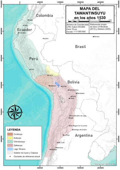
Dispossesions in the Americas

Dispossesions in the Americas

  • Home
  • Explore
  • About
  • Authors
  • Art
  • Bodies
  • Curricula
  • Cultural Heritage
  • Maps
  • Territories
Back to Explore
Map Commentary 1500 - 1599

QULLASUYU PROVINCES UNDER INCA RULE EARLY 16TH CENTURY

  • Medeiros, Carmen

  • Grisi, Celina

  • Sánchez Patzy, Radek

  • Download Image
Platt, T., Bouysse-Cassagne, T., & Harris, O. (2006). Qaraqara-Charka: Mallku, Inka y rey en la Provincia de Charcas (siglos XV – XVII): Historia antropológica de una confederación aymara. Edición documental y ensayos interpretativos. Con el aliento de Thierry Saignes. Instituto Francés de Estudios Andinos, Plural Editores, Fundación Cultural del Banco Central de Bolivia, University of St. Andrews.

Platt, T., Bouysse-Cassagne, T., & Harris, O. (2006). Qaraqara-Charka: Mallku, Inka y rey en la Provincia de Charcas (siglos XV – XVII): Historia antropológica de una confederación aymara. Edición documental y ensayos interpretativos. Con el aliento de Thierry Saignes. Instituto Francés de Estudios Andinos, Plural Editores, Fundación Cultural del Banco Central de Bolivia, University of St. Andrews.

Abstract

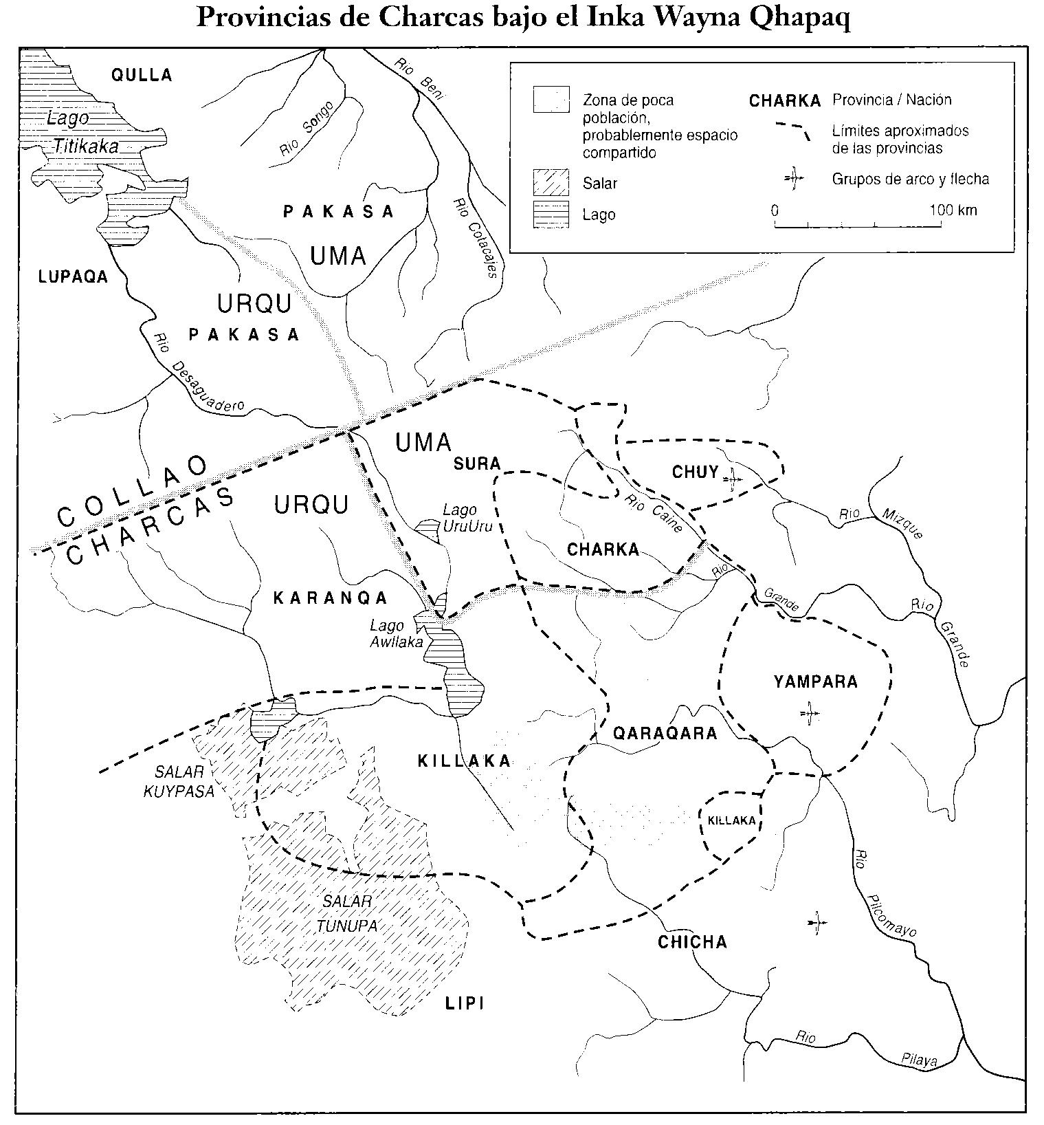
The map displays the altiplano, which was an important part of the Qullasuyu,that is, the southern district of the Inca state or Tawantinsuyu. At the beginning of the 16th century, a time of state expansion, under the rule of Inka Wayna Qhapaq, the altiplano was divided into two provinces. Namely, the Collao in the northern part where the Aymara lordships of the Pakaxa, Lupaqa, Qulla, Kanas and Kanchis peoples were located, and the province of Charcas, in the southern part, which was occupied by the Karanqa, Sura, Killaka, Charka, Qaraqara, Chicha and other non-Aymara polities (e.g., Chuy and Yampara). The map focuses on this southern part.1 Located in the central eastern part, the Sura territories “separated in a wedge-shaped” the central settlements of the Pakaxa, Killaka and Karanqas, and the political centers of the “Charka Confederation” located to the south.2 Additionally, this map portrays the division of urcu/uma corresponding to the Andean dualistic/quadruple view in which space is organized in two opposing but complementary parts (upper and lower) and articulated through a midpoint (taypi).

The names of the Aymara Lordships AYMARA POLITIES of THE QULLASUYU in the 16th CENTURY differ in different maps because their spelling also varied in colonial documents, so there are several alternative names for a single lordship, as is the case with the Pakaxa, according to this map, which in others appear as Pacajes or Pakajaqi.

Under Spanish colonial rule, the Qullasuyu became the Audiencia de Charcas also called Audiencia de la Plata because of the importance of the silver mines of Potosi, an important district of the Viceroyalty of Peru during the 16th and 17th centuries. With the advance of Spanish rule, the province of Collao had the archdiocese of La Paz as its main metropolitan see, whereas the province of Charcas had the archdiocese of La Plata instead.

REFERENCES:

Del Rio, Mercedes. “El Tributo Indígena en el Repartimiento de Paria (siglo XVI).” Revista de Indias 50, no.189 (1990): 397-429.

Platt, Tristán, Thérèse Bouysse-Cassagne and Olivia Harris. Qaraqara-Charka: Mallku, Inka y Rey en la Provincia de Charcas (Siglos XV-XVII): Historia Antropológica de una Confederación Aymara. La Paz: Plural-IFEA, 2006).


  1. Tristan Platt, Therese Bouysse-Cassagne and Olivia Harris, *Qaraqara-Charka: Mallku, Inka y Rey en la Provincia de Charcas (Siglos XV-XVII) (*La Paz: Plural-IFEA, 2006), 45. ↩︎

  2. Mercedes del Rio, “El Tributo Indígena en el Repartimiento de Paria (siglo XVI),” Revista de Indias 50, no. 189 (1990): 77. ↩︎

  • Download Image

Reading in Spanish

Map Commentary 1500 - 1599

PROVINCIAS DEL QULLASUYU BAJO DOMINIO INCA PRINCIPIOS DEL SIGLO XVI

  • Medeiros, Carmen

  • Grisi, Celina

  • Sánchez Patzy, Radek

  • Download Image
Platt, T., Bouysse-Cassagne, T., & Harris, O. (2006). Qaraqara-Charka: Mallku, Inka y rey en la Provincia de Charcas (siglos XV – XVII): Historia antropológica de una confederación aymara. Edición documental y ensayos interpretativos. Con el aliento de Thierry Saignes. Instituto Francés de Estudios Andinos, Plural Editores, Fundación Cultural del Banco Central de Bolivia, University of St. Andrews.

Platt, T., Bouysse-Cassagne, T., & Harris, O. (2006). Qaraqara-Charka: Mallku, Inka y rey en la Provincia de Charcas (siglos XV – XVII): Historia antropológica de una confederación aymara. Edición documental y ensayos interpretativos. Con el aliento de Thierry Saignes. Instituto Francés de Estudios Andinos, Plural Editores, Fundación Cultural del Banco Central de Bolivia, University of St. Andrews.

  • Download Image

Related Content

AYMARA POLITIES of THE QULLASUYU in the 16th CENTURY

AYMARA POLITIES of THE QULLASUYU in the 16th CENTURY

Map Commentary 1530 - 1539
THE QULLASUYU IN THE 1530s – SOUTHERN DISTRICT OF THE INCA STATE

THE QULLASUYU IN THE 1530s – SOUTHERN DISTRICT OF THE INCA STATE

Map Commentary 1530 - 1539
THE TAWANTINSUYU IN THE 1530s – TERRITORY OF THE INCA STATE

THE TAWANTINSUYU IN THE 1530s – TERRITORY OF THE INCA STATE

Map Commentary 1530 - 1539

Dispossessions in the Americas

A project by

University of Pennsylvania

Copyright 2024

With support from

Mellon Foundation

Site design & development

Element 84

Art Credits

Platt, T., Bouysse-Cassagne, T., & Harris, O. (2006). Qaraqara-Charka: Mallku, Inka y rey en la Provincia de Charcas (siglos XV – XVII): Historia antropológica de una confederación aymara. Edición documental y ensayos interpretativos. Con el aliento de Thierry Saignes. Instituto Francés de Estudios Andinos, Plural Editores, Fundación Cultural del Banco Central de Bolivia, University of St. Andrews.

Site Pages

  • Home
  • Explore
  • About
  • Authors
  • Art
  • Bodies
  • Curricula
  • Cultural Heritage
  • Maps
  • Territories