Dispossesions in the Americas

Dispossesions in the Americas

  • Home
  • Explore
  • About
  • Authors
  • Art
  • Bodies
  • Curricula
  • Cultural Heritage
  • Maps
  • Territories
Back to Explore
Map Commentary 1500 - 1599

THE AYMARA LORDSHIP OF THE SURAS IN THE 16TH CENTURY

  • Medeiros, Carmen

  • Grisi, Celina

  • Sánchez Patzy, Radek

Published: 2024

  • Download Image
Del Río, M. (2005). Etnicidad, territorialidad y colonialismo en los Andes: Tradición y cambio entre los Soras de los siglos XVI Y XVII (Bolivia). Instituto de Estudios Bolivianos.

Del Río, M. (2005). Etnicidad, territorialidad y colonialismo en los Andes: Tradición y cambio entre los Soras de los siglos XVI Y XVII (Bolivia). Instituto de Estudios Bolivianos.

Abstract

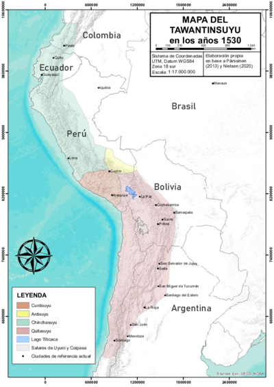
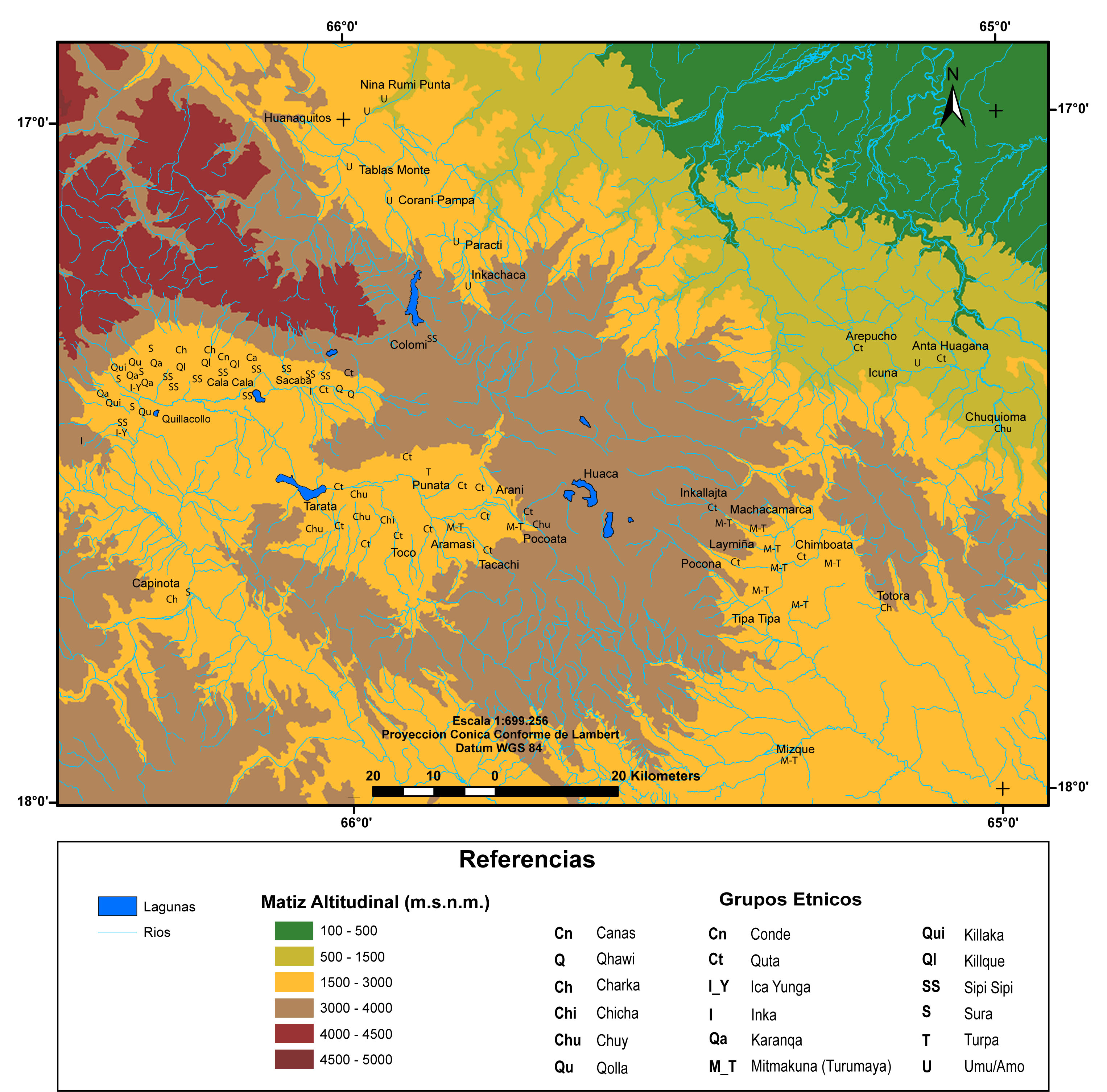
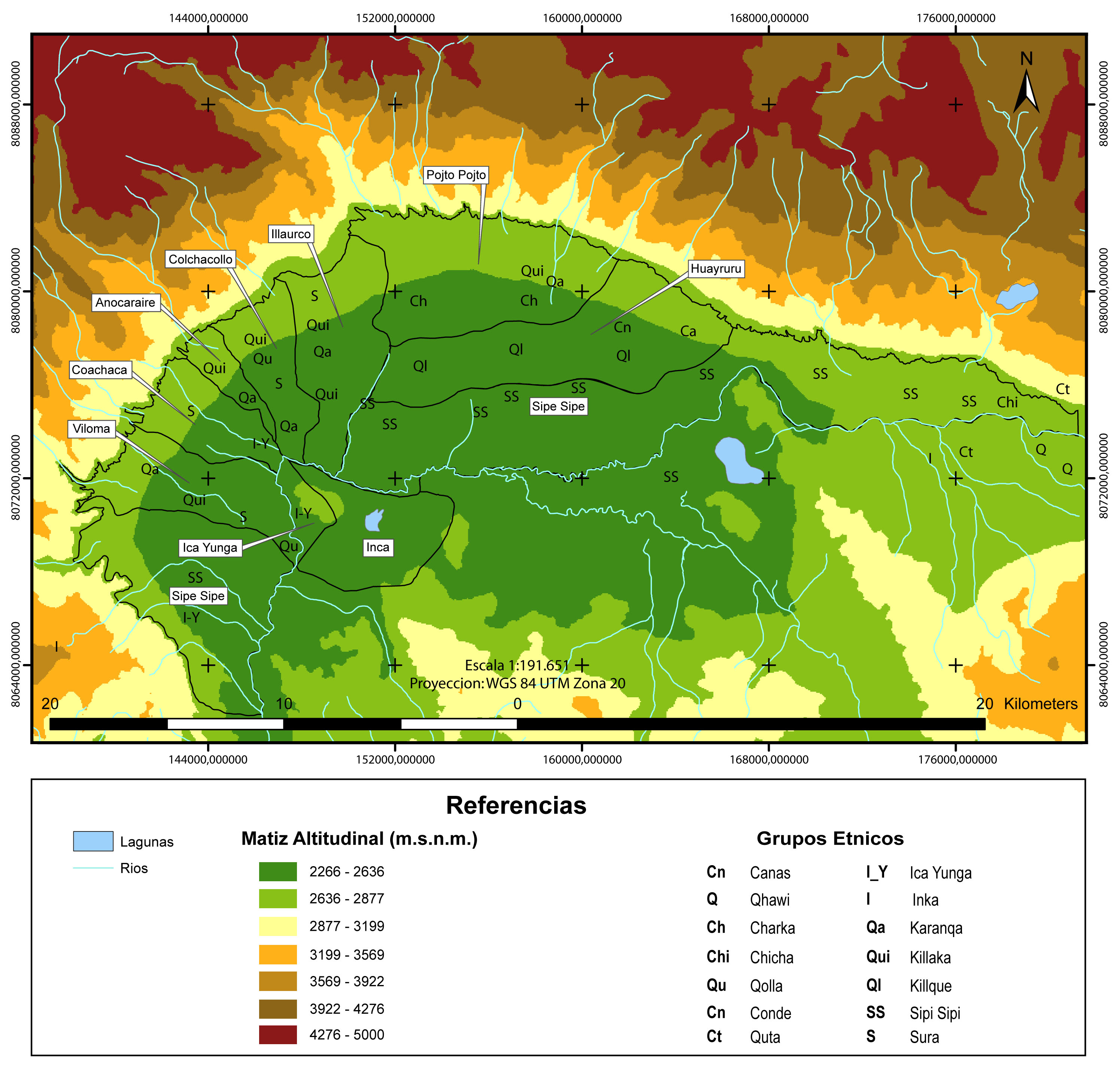
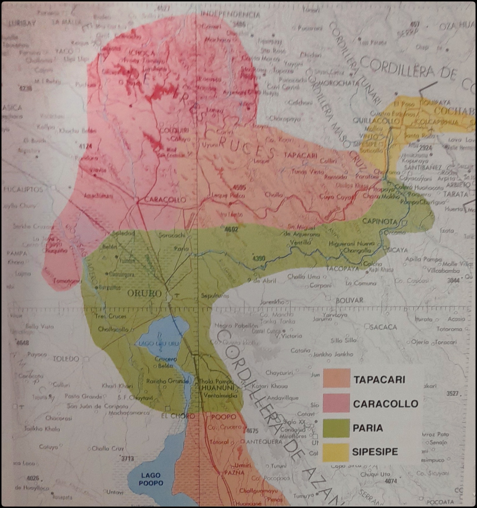
The map displays the four Aymara polities AYMARA POLITIES of THE QULLASUYU in the 16th CENTURY that formed the Sura Federation —or Sora, Sulla, Zora, Çora or Çoraçora, depending on the source consulted—: the Sura of Paria, Tapacarí, Caracollo and Sipe Sipe in the Qullasuyu territory THE QULLASUYU IN THE 1530s – SOUTHERN DISTRICT OF THE INCA STATE , southern district of the Inca state or Tawantinsuyu.1 Each had its own territory (with a subdivision into two upper and lower halves). Before the 16th century, these four political entities could have been integrated as one or as a diarchy with two main sections, Paria as the upper half and Tapacari as the lower half. However, there is no historical evidence to support either hypothesis.2 The Sura territories included a large area of the eastern center of the altiplano —currently the department of Oruro—, and extended eastward through the Tapacari and Arque river valleys —in the department of Cochabamba. Following the model of vertical control of ecological niches and territorial discontinuity, the central settlements were in the altiplano, and the various ethnic “islands” stood along the inter-Andean valleys.

The case of the Sura, however, presents slight adaptations in relation to this general model of the Aymara lordships AYMARA POLITIES of THE QULLASUYU in the 16th CENTURY . These variations could have been the result of Inca territorial reorganization policies. The Sura territory of Sipe Sipe was entirely situated in the valleys. However, the Sura central settlement of Tapacarí was not located in the altiplano, but in the middle of the Tapacarí river valley. It is also worth noting that the altiplano settlements of the Sura population from Tapacarí were at a greater distance and more clearly spread out from their valley settlements than in the other cases.3

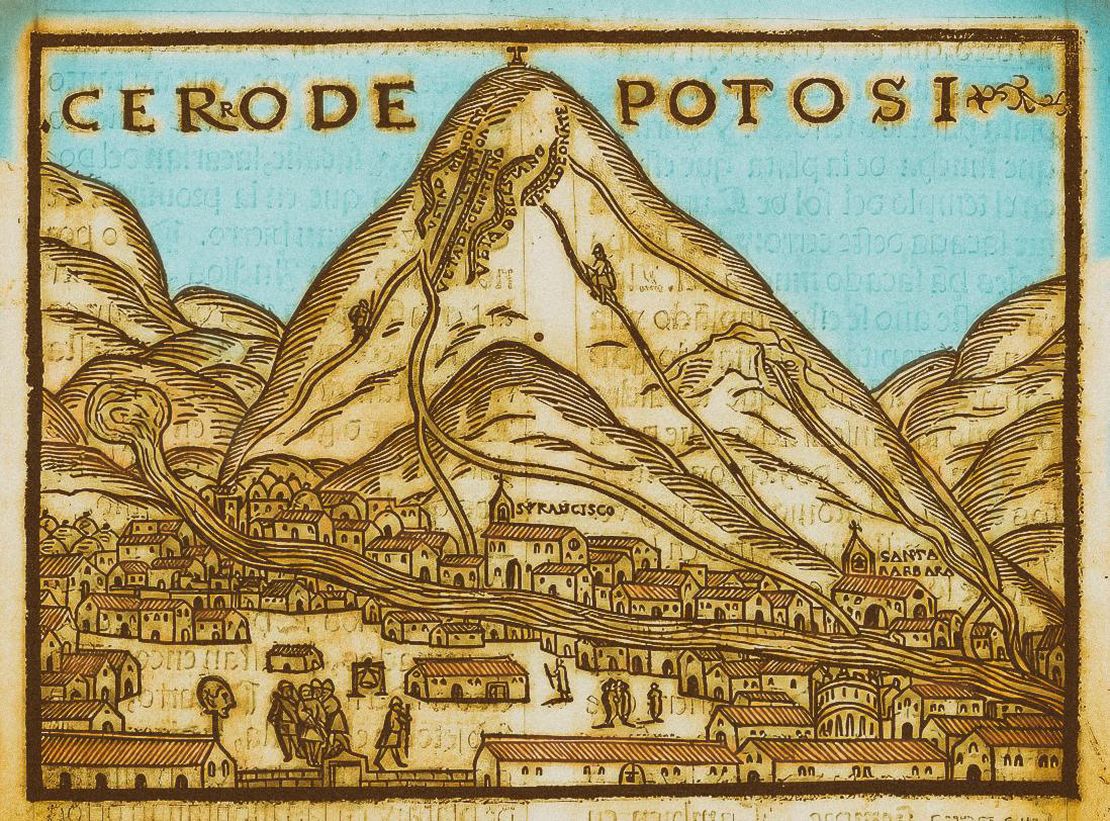
Since the Sura territories extended eastward along the Tapacarí and Arque river valleys, both in Inca and colonial times, these valleys formed a “natural corridor” connecting the multi-ethnic MULTI-ETHNIC TERRITORY under INCA DIRECT RULE: THE CENTRAL AND UPPER VALLEYS OF COCHABAMBA in the 1530s territory MULTI-ETHNIC TERRITORY under INCA DIRECT RULE: THE LOWER VALLEY OF COCHABAMBA in the 1530s of the Cochabamba valleys with the altiplano. Under the Inca rule, maize produced in the Inca state lands was transported by llamas to Cuzco. Under Spanish colonial rule, agricultural products from the valley-based haciendas were taken to the markets of the silver mines of Potosí.

In no time, the Sura were impacted by the new colonial regime that had undergone drastic changes, especially in terms of their territorial patterns. The first encomienda system covered the population in “the Soras province”, as the important administrative center of Paria turned into a military base for Spanish soldiers. The territorial center of Suras in Paria moved to the valleys of Cochabamba. By the late 1540s, the Indigenous population of the Sura territories had been “distributed” into four repartimientos —colonial territorial-population unit— and assigned to four different encomenderos under the encomienda labor system. Although this allowed the Sura peoples to maintain and extend their original groups during the colonial period, these new repartimientos disrupted the federation´s structure, considered as the maximum level of intersection among the numerous centers.4 This new colonial scheme added to the fact that Paria, their main administrative center, had been relocated, marked the beginning of a new fragmentation process of the Sura macro-ethnic federation. Moreover, the establishment of these four repartimientos had not considered the existence of the Sura colonies or ethnic “islands” that had been relocated by the Inca state to places far from the main Sura territories. This meant that “the Sura who had been [relocated by the Incas], had been also separated from their groups of origin and integrated into different encomienda labor systems.” 5 There is no doubt that the repartimiento and encomienda —as colonial forms of population organization for the extraction and collection of surplus and labor recruitment— represented a threat and a heavy burden for the Sura polities. However, since their territorial and social organization as well as their forms of production had remained relatively unaffected, the Sura were able to withstand the burden and pressures without significantly undermining their self-sufficiency capabilities.

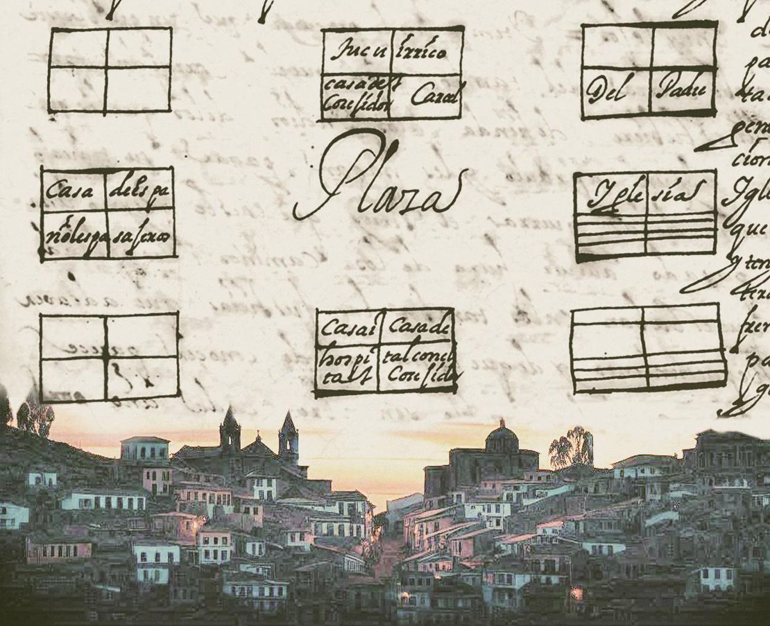
Greater and even more radical transformations occurred in the context of the major reforms implemented in the 1570s by Viceroy Toledo to consolidate and institutionalize the presence of the colonial state, and increase silver production in the Potosí mines. The three reforms that most affected the Aymara lordships, in general, and the Sura, in particular, were the following: 1) the forced resettlement of scattered villages and their concentration or “reduction” into central towns called “Pueblos Reales de Indios” COLONIAL LEGISLATIONS AS FRAMEWORK FOR DISPOSSESSIONS IN THE CENTRAL ANDES: THE “REDUCCIONES” OR “PUEBLOS REALES DE INDIOS” ; 2) the rationalization, individualization and monetization of the Indigenous tribute COLONIAL LEGISLATION AS THE FRAMEWORK FOR DISPOSSESSIONS IN THE CENTRAL ANDES: THE INDIGENOUS TRIBUTE 1570s -1620s ; and 3) the mandatory recruitment of Indigenous labor for the mines of Potosí known as the mita system COLONIAL LEGISLATIONS AS A FRAMEWORK FOR DISPOSSESSIONS IN THE CENTRAL ANDES: THE COLONIAL MITA . Conceived as a rationalization of the colonial administration of territories and populations, and as a systematization of the mechanisms of surplus extraction, collection, and labor, these three reforms were closely articulated. The reducciones played a key role in this arrangement. Indeed, the reducciones made it possible to govern the “Indians” and evangelize them in a more orderly manner, collect tribute more systematically, and recruit workers on duty for the mita labor system more efficiently.

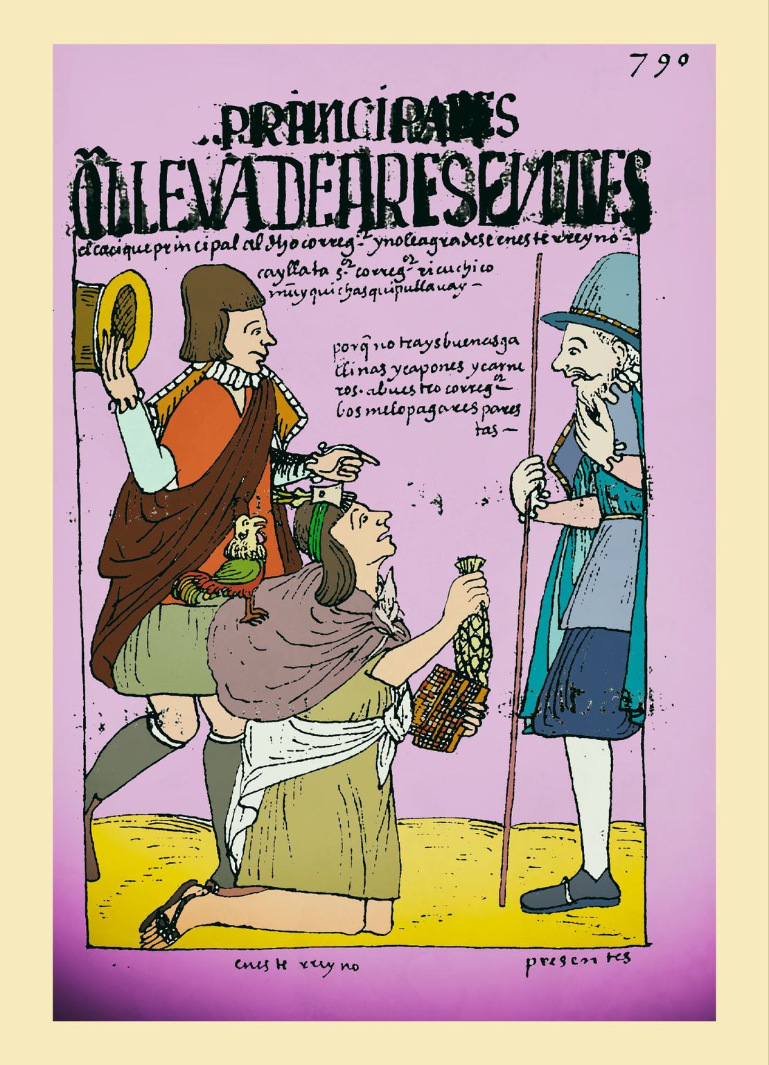
The “reduction of Indians” implied the disruption of the Sura people’s territorial organization, the uprooting of hundreds of villages scattered throughout the valleys, and the rearrangement of their kinship networks and ethnic identities, as the forced resettlements were rather arbitrary and ended up concentrating families with different ethnic affiliations in the same pueblo real de indios. Although groups were organized within each village following and maintaining elements of the ayllu structure, these were groups with a new configuration, something like reshuffled ayllus that in time became the main reference for the development of new ethnic identities on a much smaller scale than the macro-polis the Sura had reached. In terms of tax reforms, the monetization of the Indigenous tribute led to a greater integration of the Sura into the market. The way for the Sura people to earn the money to meet their tribute obligations was through selling what they had produced, more specifically their woven clothing items and garments.6 The mita obligations in the Paria repartimiento involved working in the mines of Potosí, working in other mines, performing agricultural work in the Spanish haciendas, conducting domestic work in convents and hospitals, and carrying out postal and transport services, all of which presented a very heavy burden, particularly in the context of the demographic decline that characterized the 17th century.

By the end of the colonial period and the beginning of the 19th century, the great federation of four Sura polities had been completely dismantled. The strong connections between the highlands and the valleys that had characterized the territories of three of the four Sura confederations had been deeply severed, destroying the pattern of macro-vertical control of the ecological niches with significant and profound implications in terms of dispossessions. At this point, the Sura name and even more the memory of having belonged to a large Sura polity had completely vanished. The four Sura polities had shattered into a multiplicity of reorganized ayllus or into the so-called “Indian communities” —term acquired during the colony.

While in the altiplano region the Sura descendants managed to maintain collective ownership of the land as reorganized ayllus or Aymara-speaking Indigenous communities, the consolidation of private property in the valleys turned many of them into Quechua-speaking peasants subject to the hacienda servile structures. This situation —long-lasting and especially exacerbated after the creation of the Republic of Bolivia—, changed with the Agrarian Reform of 1953 when the lands of the large haciendas were redistributed as individual private properties to the Indigenous people organized in agrarian unions commonly called sindicatos de campesinos (peasant unions). In this new context, some Indigenous communities of the altiplano remained as ayllus with collective land ownership, whereas others processed individual land titles and organized themselves as peasant unions.

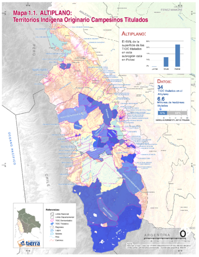
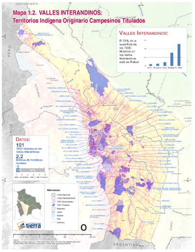
In the context of the current Plurinational State of Bolivia and the 2009 Constitution recognizing the legal classification of “Territorios Indígenas Originarios Campesinos” TITLED INDIGENOUS TERRITORIES (TIOC) IN THE BOLIVIAN ALTIPLANO AS OF 2011 or TIOCS, there has been a renewed interest by many Indigenous communities of the altiplano and some peasant unions of the valleys to organize themselves as ayllus and demand the titling of their lands as TIOCS. However, these demands have been made by independent ayllus and do not necessarily have the goal of reconstructing the territories as part of the Sura macro-polity. There are currently 17 recognized Indigenous territories in the grounds of what used to be the great Aymara lordships of the Sura Federation in the 16th century.7 Ten of these territories are in the highlands of Oruro department while the other seven are in the Cochabamba department. The Oruro territories represent almost 360,000 hectares while those of Cochabamba amount to 935,000 hectares. An estimated total of 105,000 people live in these territories.8 Are these Indigenous peoples, mostly Qhishwa-speaking —except for the inhabitants in the highland Tapacari and Paria parts—, descendants of the Sura of Paria and Tapacari polities that had controlled the territories of what are now the provinces of Arque and Tapacari respectively in the 16th century? Some of them could be, others could be descendants of the “outsiders” who migrated to these regions from other Aymara polities during the colonial period. At the beginning of the 21st century and up to the present day, their identities have been defined mainly by their belonging to a specific Indigenous/peasant community of origin, on the one hand, and to a strong peasant union structure on the other. The memories of belonging to a larger unit or even of the name Sura have been lost in the historical process.

REFERENCES:

del Río, Mercedes. Etnicidad, Territorialidad y Colonialismo En los Andes: Tradición y Cambio entre los Soras de los Siglos XVI y XVII (Bolivia). La Paz: Instituto de Estudios Bolivianos, 2005.

Fundación Tierra. Territorios Indígena Originario Campesinos en Bolivia. Entre la Loma Santa y la Pachamama. Informe 2011. La Paz: Fundación Tierra, 2011.

Schramm, Robert. “Fronteras y Territorialidad: Repartición Étnica y Política Colonizadora en los Charcas (Valles de Ayopaya y Mizque).” In Espacio, Etnias, Frontera: Atenuaciones Políticas en el Sur del Tawantinsuyu Siglos XV - XVIII, compiled by Ana María Presta, 163-188. Sucre, Bolivia: ASUR, 1995


  1. Mercedes del Río, Etnicidad, Territorialidad y Colonialismo en los Andes: Tradición y Cambio entre los Soras de los Siglos XVI y XVII (Bolivia) (La Paz: Instituto de Estudios Bolivianos, 2005). ↩︎

  2. del Río, Etnicidad, Territorialidad y Colonialismo en los Andes: Tradición y Cambio entre los Soras de los Siglos XVI y XVII (Bolivia); Robert Schramm, “Fronteras y Territorialidad: Repartición Étnica y Política Colonizadora en los Charcas (Valles de Ayopaya y Mizque),” in Espacio, Etnias, Frontera: Atenuaciones Políticas en el Sur del Tawantinsuyu Siglos XV - XVIII, ed. Ana María Presta (Sucre: ASUR, 1995), 163-188. ↩︎

  3. del Río. Etnicidad, Territorialidad y Colonialismo en los Andes. ↩︎

  4. del Río. Etnicidad, Territorialidad y Colonialismo En Los Andes, 283. ↩︎

  5. del Río. Etnicidad, Territorialidad y Colonialismo En Los Andes, 105. ↩︎

  6. del Río. Etnicidad, Territorialidad y Colonialismo En Los Andes. ↩︎

  7. Fundación Tierra, Territorios Indígena Originario Campesinos en Bolivia. Entre la Loma Santa y la Pachamama, Informe 2011, (La Paz: Fundación Tierra, 2011). ↩︎

  8. Fundación Tierra, Territorios Indígena Originario Campesinos en Bolivia. Entre la Loma Santa y la Pachamama, Report 2011. ↩︎

Citation

Medeiros, Carmen, Celina Grisi, and Radek Sánchez Patzy. 2024. 'THE AYMARA LORDSHIP OF THE SURAS IN THE 16TH CENTURY'. Dispossessions in the Americas. https://staging.dia.upenn.edu/en/content/BOL0027Y/

  • Download Image

Reading in Spanish

Map Commentary 1500 - 1599

EL SEÑORÍO AYMARA DE LOS SURAS EN EL SIGLO XVI

  • Medeiros, Carmen

  • Grisi, Celina

  • Sánchez Patzy, Radek

Published: 2024

  • Download Image
Del Río, M. (2005). Etnicidad, territorialidad y colonialismo en los Andes: Tradición y cambio entre los Soras de los siglos XVI Y XVII (Bolivia). Instituto de Estudios Bolivianos.

Del Río, M. (2005). Etnicidad, territorialidad y colonialismo en los Andes: Tradición y cambio entre los Soras de los siglos XVI Y XVII (Bolivia). Instituto de Estudios Bolivianos.

  • Download Image

Reading in Portuguese

Map Commentary 1500 - 1599

O SENHORIO AIMARÁ DOS SURAS NO SÉCULO XVI

  • Medeiros, Carmen

  • Grisi, Celina

  • Sánchez Patzy, Radek

Published: 2024

BOL0027Y: No image found

BOL0027Y

O SENHORIO AIMARÁ DOS SURAS NO SÉCULO XVI

Carmen Medeiros, Celina Grisi e Radek Sánchez

[XXX insert map BOL0027 with title and reference_nt as caption]

O mapa mostra as quatro entidades políticas aimarás [XXX link para BOL0003Y] que formaram a Confederação Sura [ou Sora, Sulla, Zora, Çora ou Çoraçora, dependendo da fonte consultada]: os Sura de Paria, de Tapacarí, de Caracollo e de Sipe Sipe no território do Qullasuyu [XXX link para BOL0002Y], distrito sul do Estado Inca ou Tawantinsuyu [XXX link para BOL0001Y].1 Cada uma tinha seu próprio território (subdividido em duas metades, superior e inferior). Antes do século XVI, essas quatro entidades políticas poderiam ter se integrado como uma única entidade ou como uma diarquia com duas metades principais, Paria como a metade superior e Tapacarí como a metade inferior; porém, não há evidência histórica que sustente qualquer uma dessas hipóteses.2 Os territórios Sura abrangiam uma grande superfície do centro oriental do altiplano (no atual departamento de Oruro) estendendo-se para o leste pelos vales dos rios Tapacarí e Arque (no departamento de Cochabamba). Seguindo o modelo de controle vertical de nichos ecológicos e descontinuidade territorial, os assentamentos centrais estavam localizados no altiplano, enquanto as diversas “ilhas” étnicas ao longo dos vales interandinos. [LEIA MAIS]

O caso dos Sura, no entanto, apresenta leves variações em relação a este modelo geral dos senhorios aimarás [XXX link para BOL0003Y]. Essas variações podem ter sido resultado das políticas de reorganização territorial incaica. O território dos Sura de Sipe Sipe estava inteiramente localizado nos vales, enquanto o assentamento central dos Sura de Tapacarí não estava no altiplano, mas no meio do vale do rio Tapacarí. Cabe destacar que os assentamentos dos Sura de Tapacarí no altiplano estão localizados mais distantes e mais claramente separados de seus assentamentos nos vales do que em outros casos.3

Dado que os territórios Sura se estendiam para o oriente pelos vales dos rios Tapacarí e Arque, tanto na época inca quanto na época colonial, esses vales formavam um “corredor natural” que conectava o território [XXX link para BOL0006Y] multiétnico [XXX link para BOL0007Y] dos vales de Cochabamba com o altiplano. Sob o domínio inca, o milho produzido nas terras do Estado Inca era transportado por lhamas até Cuzco; sob o domínio colonial espanhol, os produtos agrícolas das fazendas do vale eram levados aos mercados das minas de prata de Potosí.

Os Sura foram imediatamente afetados pelo novo regime colonial, que trouxe mudanças drásticas, especialmente quanto aos seus padrões territoriais. A primeira encomienda [XXX link para TL001Encomienda] abrangeu a população da “província dos Soras” e o importante centro administrativo de Paria tornou-se uma base militar para os soldados espanhóis. O centro territorial dos Sura de Paria deslocou-se para os vales de Cochabamba. No final da década de 1540, a população indígena dos territórios Sura estava “distribuída” em quatro repartimentos (unidade territorial - população colonial) e designada em encomienda [XXX link para TL001Encomienda] a quatro encomenderos diferentes. Embora isso tenha permitido aos Sura manter e expandir seus grupos originais durante o período colonial, esses novos repartimentos quebraram a estrutura da confederação, considerada como o nível máximo de sobreposição dos diferentes centros.4 Este novo esquema colonial e o fato de Paria, seu principal centro administrativo, ter sido realocado, marcou o início de um novo processo de fragmentação da macro confederação étnica Sura. Além disso, o estabelecimento desses quatro repartimentos não levou em consideração a existência de colônias ou “ilhas” étnicas dos Sura que tinham sido realocadas pelo Estado Inca em locais afastados dos principais territórios Sura. Isso significou que “os Sura que tinham sido realocados pelos incas fossem separados de seus grupos originais e integrados em diferentes encomiendas”. 5 Sem dúvida, essas formas coloniais de organização da população para a extração de excedentes e mão de obra, repartimento e encomienda, representou uma ameaça e uma pesada carga para as entidades políticas Sura. No entanto, como sua organização territorial e social e suas formas de produção permaneceram relativamente inalteradas, os Sura conseguiram suportar a carga e as pressões sem comprometer significativamente sua capacidade de autossuficiência.

Transformações ainda maiores e mais radicais ocorreram no contexto das grandes reformas implementadas pelo vice-rei Toledo para consolidar e institucionalizar a presença do Estado colonial e aumentar a produção de prata nas minas de Potosí. As três reformas que mais afetaram os senhorios aimarás, em geral, e os Sura, em particular, foram 1) o reassentamento forçado de aldeias dispersas e sua concentração ou ‘redução’ em povoados nucleares chamados ‘Pueblos Reales de Indios’ [XXX link para TL003Reducciones]; 2) A racionalização, individualização e monetização do tributo indígena [XXX link para TL004Tributo]; e 3) o recrutamento compulsório de mão de obra indígena para as minas de Potosí conhecido como o sistema de mita [XXX link para TL005Mita]. Concebidas como uma racionalização da administração colonial de territórios e populações e como forma de sistematização dos mecanismos de extração de excedentes e do trabalho, essas três reformas estavam estreitamente articuladas, sendo as reduções a peça-chave dessa articulação, já que nas reduções os ‘índios’ podiam ser governados e evangelizados de forma mais ordenada, o tributo arrecadado sistematicamente e os trabalhadores recrutados para a mita de forma mais eficiente.

A “redução de índios” implicou o desmantelamento da organização territorial dos Sura, o desenraizamento de centenas de aldeias espalhadas ao longo dos vales e a reconfiguração de suas redes de parentesco e identidades étnicas, já que os reassentamentos forçados eram arbitrários e acabaram concentrando famílias de diferentes etnias. Embora no interior de cada povoado se organizassem grupos que mantinham elementos da estrutura ayllu, esses grupos tinham uma nova composição, uma espécie de ayllus reconstituídos que, com o tempo, se tornaram uma referência para a formação de novas identidades étnicas em uma escala muito menor do que a macro entidade dos Sura. No que diz respeito às reformas tributárias, a monetização do tributo indígena [XXX link para TL004Tributo] levou a uma maior integração dos Sura no mercado. Para obter o dinheiro do tributo, o povo Sura tinha que vender o que produzia, especialmente, no caso deles, as roupas tecidas.6 As obrigações da mita [XXX link para TL005Mita] no repartimento de Paria incluíam, além do trabalho nas minas de Potosí, o trabalho em outras minas, o trabalho agrícola nas fazendas espanholas, o trabalho doméstico em conventos e hospitais e os serviços postais e de transporte, o que representou uma carga muito pesada, em especial no declínio demográfico que caracterizou o século XVII.

Ao final do período colonial, no início do século XIX, a grande confederação de quatro entidades políticas Sura tinha sido completamente desarticulada. As fortes conexões entre as terras do altiplano e os vales que caracterizavam os territórios de três das quatro confederações Sura, tinham sido profundamente afetadas, destruindo, assim, o padrão de controle macro vertical dos pisos ecológicos com implicações significativas e profundas em termos de desapropriação. Neste ponto, o nome Sura e, ainda mais, a memória de ter pertencido a uma grande entidade política Sura tinham desaparecido completamente. As quatro entidades políticas se fragmentaram em uma multiplicidade de ayllus reconstituídos ou ‘comunidades índias’, denominação adquirida durante a colônia.

Enquanto na região do altiplano os descendentes dos Sura conseguiram manter a propriedade coletiva da terra como ayllus reconstituídos ou comunidades indígenas falantes do aimará, nos vales a consolidação da propriedade privada transformou muitos deles em camponeses falantes do quéchua submetidos as relações servis das fazendas. Esta situação, que se prolongou e até se agravou após a criação da República da Bolívia, mudou com a Reforma Agrária de 1953, quando as terras das grandes fazendas foram redistribuídas como propriedades privadas individuais para os indígenas organizados em sindicatos agrários comumente chamados sindicatos campesinos. Nesse novo contexto, algumas comunidades indígenas do altiplano permaneceram como ayllus com propriedade coletiva das terras enquanto outras obtiveram títulos de propriedade individual e se organizaram em sindicatos camponeses.

No contexto atual do Estado Plurinacional da Bolívia e da Constituição de 2009. que reconhece a figura legal de “Territórios Indígenas Originários Camponeses” [XXX link para BOL0022Y] TIOCs [XXX link para BOL0023Y], existe um renovado interesse das muitas comunidades indígenas do altiplano e de alguns sindicatos campesinos dos vales em se organizarem como ayllus e em reivindicar a titulação de suas terras como TIOCs. No entanto, essas reivindicações são feitas por ayllus independentes e não visam necessariamente a reconstituição dos territórios da macro entidade política dos Sura. Atualmente, existem 17 territórios indígenas reconhecidos nas terras do que foram os grandes senhorios aimará da Confederação Sura no século XVI.7 Dez desses territórios estão localizados no altiplano do departamento de Oruro, enquanto os outros sete estão no departamento de Cochabamba. Os territórios de Oruro representam quase 360.000 hectares, enquanto os de Cochabamba totalizam 935.000 hectares. No total, cerca de 105.000 pessoas habitam esses territórios.8 São esses povos indígenas, em sua maioria falantes de qhishwa (com exceção dos habitantes de Tapacarí e Paria, no altiplano), descendentes das entidades políticas Sura de Paria e Tapacarí que controlavam os territórios das atuais províncias de Arque e Tapacarí, respectivamente, no século XVI? Possivelmente, alguns sim; outros podem ser descendentes dos “forasteiros” que migraram para essas regiões vindos de outras entidades políticas aimarás durante o período colonial. No início do século XXI e até hoje, suas identidades são definidas principalmente por seu pertencimento a uma comunidade de origem indígena/campesina específica, de um lado e, do outro, a uma forte estrutura sindical campesina. A memória de uma unidade maior ou do nome Sura se perdeu no processo histórico.

REFERÊNCIAS:

del Río, Mercedes. Etnicidad, Territorialidad y Colonialismo En los Andes: Tradición y Cambio entre los Soras de los Siglos XVI y XVII (Bolívia). La Paz: Instituto de Estudios Bolivianos, 2005.

Fundación Tierra. Territorios Indígena Originario Campesinos en Bolivia. Entre la Loma Santa y la Pachamama, Informe 2011. La Paz: Fundación Tierra, 2011.

Schramm, Robert. “Fronteras y Territorialidad: Repartición Étnica y Política Colonizadora en los Charcas (Valles de Ayopaya y Mizque).” In Espacio, Etnias, Frontera: Atenuaciones Políticas en el Sur del Tawantinsuyu Siglos XV - XVIII, compilado por Ana María Presta, 163-188. Sucre, Bolívia: ASUR, 1995.


  1. Mercedes del Río, Etnicidad, Territorialidad y Colonialismo en los Andes: Tradición y Cambio entre los Soras de los Siglos XVI y XVII (Bolívia) (La Paz: Instituto de Estudios Bolivianos, 2005). ↩︎

  2. del Río, Etnicidad, Territorialidad y Colonialismo en los Andes: Tradición y Cambio entre los Soras de los Siglos XVI y XVII (Bolívia); Robert Schramm, “Fronteras y Territorialidad: Repartición Étnica y Política Colonizadora en los Charcas (Vales de Ayopaya e Mizque),” em Espacio, Etnias, Frontera: Atenuaciones Políticas en el Sur del Tawantinsuyu Siglos XV - XVIII, ed. Ana María Presta (Sucre: ASUR, 1995), 163-188. ↩︎

  3. del Río. Etnicidad, Territorialidad y Colonialismo en los Andes. ↩︎

  4. del Río. Etnicidad, Territorialidad y Colonialismo En Los Andes, 283 ↩︎

  5. del Río. Etnicidad, Territorialidad y Colonialismo En Los Andes, 105 ↩︎

  6. del Río. Etnicidad, Territorialidad y Colonialismo En Los Andes. ↩︎

  7. Fundación Tierra, Territorios Indígena Originario Campesinos en Bolivia. Entre la Loma Santa y la Pachamama, Informe 2011, (La Paz: Fundación Tierra, 2011). ↩︎

  8. Fundación Tierra, Territorios Indígena Originario Campesinos en Bolivia. Entre la Loma Santa y la Pachamama, Informe 2011. ↩︎

Citation

Medeiros, Carmen, Celina Grisi, and Radek Sánchez Patzy. 2024. 'O SENHORIO AIMARÁ DOS SURAS NO SÉCULO XVI'. Dispossessions in the Americas. https://staging.dia.upenn.edu/pt/content/BOL0027Y/

Related Content

AYMARA POLITIES of THE QULLASUYU in the 16th CENTURY

AYMARA POLITIES of THE QULLASUYU in the 16th CENTURY

Map Commentary 1530 - 1539
THE QULLASUYU IN THE 1530s – SOUTHERN DISTRICT OF THE INCA STATE

THE QULLASUYU IN THE 1530s – SOUTHERN DISTRICT OF THE INCA STATE

Map Commentary 1530 - 1539
THE TAWANTINSUYU IN THE 1530s – TERRITORY OF THE INCA STATE

THE TAWANTINSUYU IN THE 1530s – TERRITORY OF THE INCA STATE

Map Commentary 1530 - 1539
MULTI-ETHNIC TERRITORY under INCA DIRECT RULE: THE CENTRAL AND UPPER VALLEYS OF COCHABAMBA in the 1530s

MULTI-ETHNIC TERRITORY under INCA DIRECT RULE: THE CENTRAL AND UPPER VALLEYS OF COCHABAMBA in the 1530s

Map Commentary 1530 - 1539
MULTI-ETHNIC TERRITORY under INCA DIRECT RULE: THE LOWER VALLEY OF COCHABAMBA in the 1530s

MULTI-ETHNIC TERRITORY under INCA DIRECT RULE: THE LOWER VALLEY OF COCHABAMBA in the 1530s

Map Commentary 1530 - 1539
COLONIAL LEGISLATION AS THE FRAMEWORK FOR DISPOSSESSIONS IN THE CENTRAL ANDES: THE ENCOMIENDA SYSTEM

COLONIAL LEGISLATION AS THE FRAMEWORK FOR DISPOSSESSIONS IN THE CENTRAL ANDES: THE ENCOMIENDA SYSTEM

Narrative 1530 - 1718
COLONIAL LEGISLATIONS AS FRAMEWORK FOR DISPOSSESSIONS IN THE CENTRAL ANDES: THE “REDUCCIONES” OR “PUEBLOS REALES DE INDIOS”

COLONIAL LEGISLATIONS AS FRAMEWORK FOR DISPOSSESSIONS IN THE CENTRAL ANDES: THE “REDUCCIONES” OR “PUEBLOS REALES DE INDIOS”

Narrative 1570 - 1749
COLONIAL LEGISLATION AS THE FRAMEWORK FOR DISPOSSESSIONS IN THE CENTRAL ANDES: THE INDIGENOUS TRIBUTE 1570s -1620s

COLONIAL LEGISLATION AS THE FRAMEWORK FOR DISPOSSESSIONS IN THE CENTRAL ANDES: THE INDIGENOUS TRIBUTE 1570s -1620s

Narrative 1570 - 1620
COLONIAL LEGISLATIONS AS A FRAMEWORK FOR DISPOSSESSIONS IN THE CENTRAL ANDES: THE COLONIAL MITA

COLONIAL LEGISLATIONS AS A FRAMEWORK FOR DISPOSSESSIONS IN THE CENTRAL ANDES: THE COLONIAL MITA

Narrative 1530 - 1790
TITLED INDIGENOUS TERRITORIES (TIOC) IN THE BOLIVIAN ALTIPLANO AS OF 2011

TITLED INDIGENOUS TERRITORIES (TIOC) IN THE BOLIVIAN ALTIPLANO AS OF 2011

Map Commentary 2009 - 2011
TITLED INDIGENOUS TERRITORIES IN THE INTER-ANDEAN VALLEYS OF BOLIVIA, AS OF 2011

TITLED INDIGENOUS TERRITORIES IN THE INTER-ANDEAN VALLEYS OF BOLIVIA, AS OF 2011

Map Commentary 2011

Dispossessions in the Americas

A project by

University of Pennsylvania

Copyright 2024

With support from

Mellon Foundation

Site design & development

Element 84

Art Credits

Del Río, M. (2005). Etnicidad, territorialidad y colonialismo en los Andes: Tradición y cambio entre los Soras de los siglos XVI Y XVII (Bolivia). Instituto de Estudios Bolivianos.

Site Pages

  • Home
  • Explore
  • About
  • Authors
  • Art
  • Bodies
  • Curricula
  • Cultural Heritage
  • Maps
  • Territories