Dispossesions in the Americas

Dispossesions in the Americas

  • Home
  • Explore
  • About
  • Authors
  • Art
  • Bodies
  • Curricula
  • Cultural Heritage
  • Maps
  • Territories
Back to Explore
Map Commentary 1573 - 1595

THE LANDS OF THE AYMARA LORDSHIP OF THE CHICHAS DE TALINA UNDER COLONIAL RULE IN THE LATE 16TH CENTURY

  • Medeiros, Carmen

  • Grisi, Celina

  • Sánchez Patzy, Radek

Published: 2024

  • Download Image
Palomeque, Silvia. "Los chichas y las visitas toledanas. Las tierras de los chichas de Talina (1573-1595)". Surandino Monográfico, segunda sección del Prohal Monográfico 1 (2): pp, 1-76.

Palomeque, Silvia. “Los chichas y las visitas toledanas. Las tierras de los chichas de Talina (1573-1595)”. Surandino Monográfico, segunda sección del Prohal Monográfico 1 (2): pp, 1-76.

Abstract

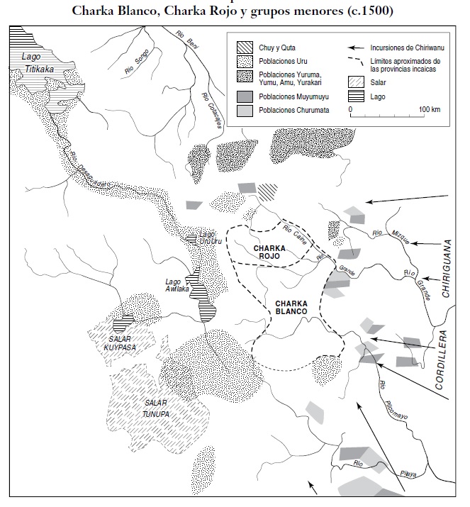
Drawn on the background of a satellite photograph and using ethnohistoric and archaeological information, this map shows the approximate location of the Pueblo Real de Indios or [Reducción](/en/content/TL003Reducciones/) de Talina, under Spanish rule in the late 16th century. In pre-colonial times, this territory was part of the [*Qullasuyu*](/en/content/BOL0002Y/), the southern district of the Inca state, a territory controlled by the [Aymara](/en/content/BOL0003Y/) lordship of the [Chichas](/en/content/BOL0028Y/). Following the model of vertical control of ecological layers and discontinuous territoriality AYMARA POLITIES of THE QULLASUYU in the 16th CENTURY , the Chichas settlements were in the high plateau region and in ecological niches along the inter-Andean valleys of present-day southwestern Bolivia. Major reforms enforced by the colonial state in the 1570s imposed the relocation of dispersed settlements into clustered villages. While the Chichas were able to gain access to land, **dispossession took the form of a complete rearrangement of their territorial organization and a disarticulation of their large political system into a variety of communities fragmented into Reductions**, as was the case of Talina.[^1]

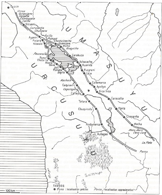
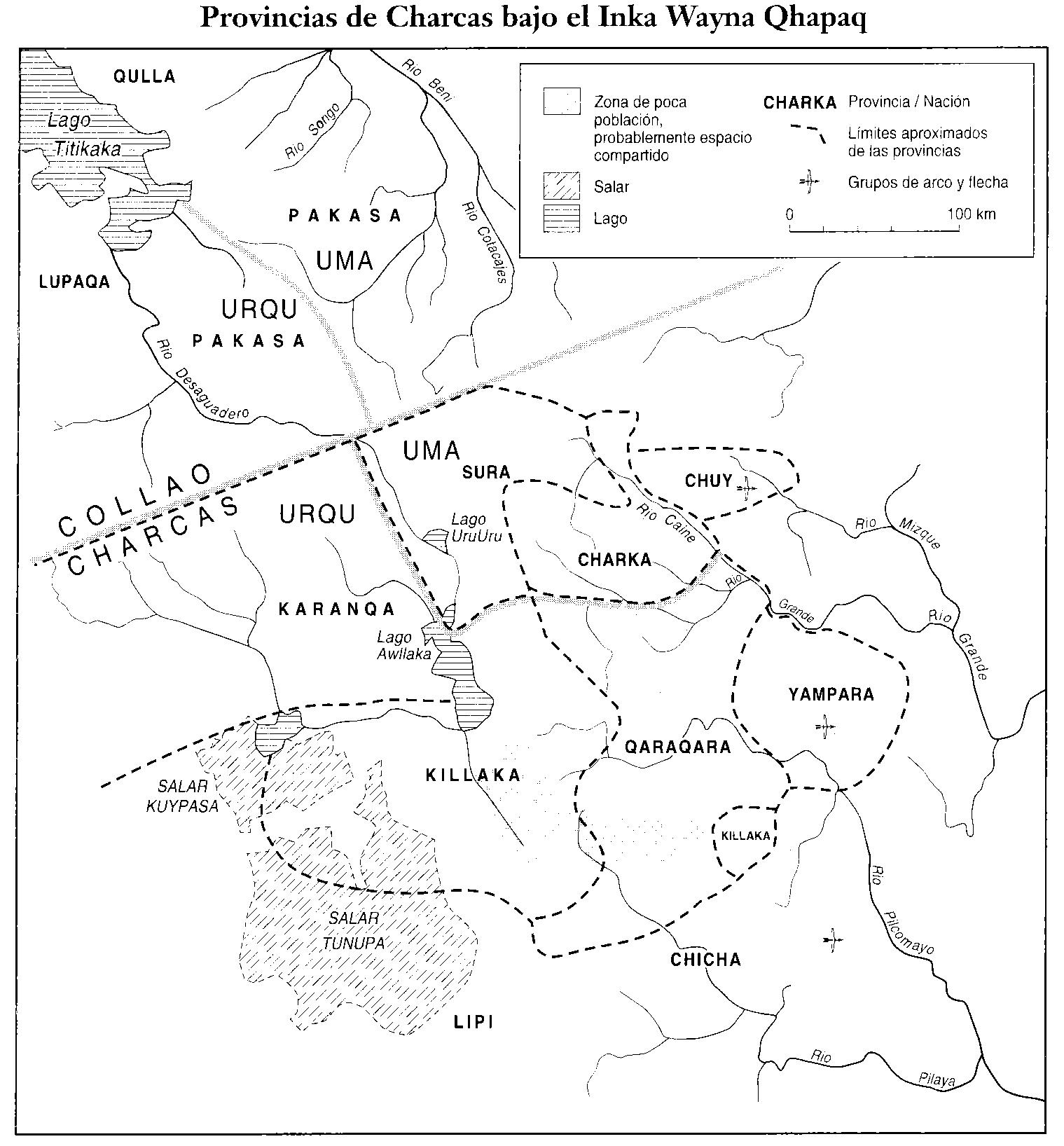
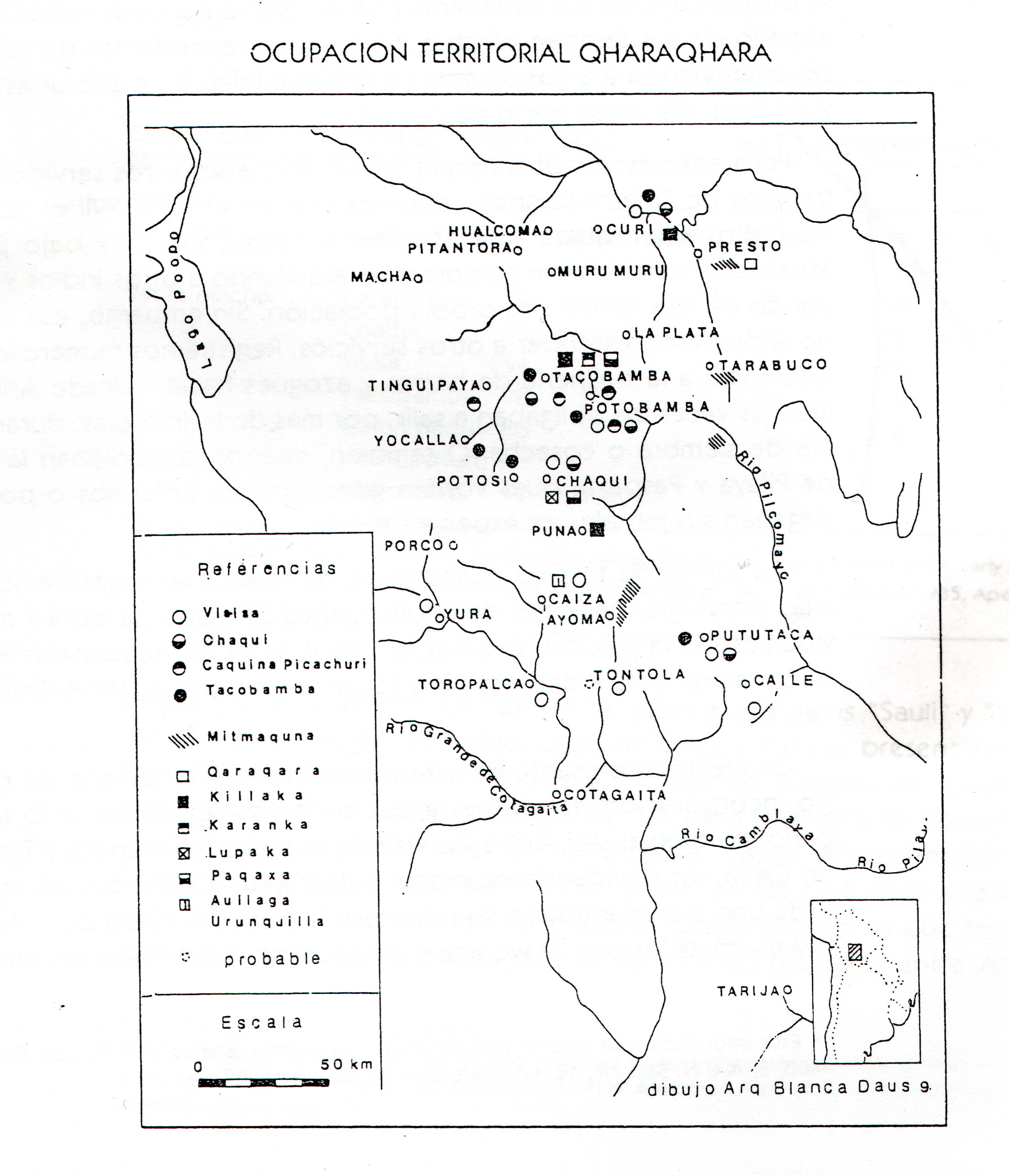
At the beginning of the 16th century the Aymara lordship of the Chichas QULLASUYU PROVINCES UNDER INCA RULE EARLY 16TH CENTURY belonging to the Qara Qara-Charka confederation, was scattered along the Inca road INCA ROADS AND TAMBOS in the 16th CENTURY that went through the present-day Calcha, Cotagaita, Tupiza, Talina —the present map examines this Reduction—, Suipacha, Moreta and other settlements that were mostly located along the watercourse of the rivers flowing down to the east.

According to the Toledo Tax, as of the 1573 census, the entire Chichas population was settled in 19 villages.1 Nine of these villages were concentrated in Talina and the other ten were rearranged between Calcha and Cotagaita, which means that the concentration of dispersed population was more acute in Talina. With the reductions, the process of fragmentation and alienation of the discontinuous territories controlled by this socio-political unit was deepened, these territories were reorganized and the Indigenous authorities (kurakas) became officials paid by the colonial state to collect the Indigenous tribute and recruit the compulsory labor force under the mita system. In turn, the reductions generated the release of large plots of land that would later be sold as part of the land compositions.

The 1573 census, known as Toledo´s General Visit, allowed the Crown to obtain statistical information about the Chichas. According to data from this census, total population amounted to 3,164 people, the taxpaying population reached 834 among adult males between 18 and 50 years old, 520 from Calcha and 314 from Talina; 217 people were noted as “old and disabled Indians who do not pay taxes”, 720 as boys up to 17 years old, and 1398 as women “of all ages and states”. 2

The Talina Reduction was in the central-eastern sector of a wide area in the puna, with a plain interrupted by the ravines formed by the Grande de San Juan River (as it is known in Argentina) or San Juan del Oro River (as it is called in Bolivia). The Reduction includes the puna highlands located south of the watercourse of said river, and the highlands and ravines and rivers integrated to the San Juan del Oro watercourse.

In 1646, the bitter experiences led to the Chichas´ decision to collect and save the money destined to the payment of their land composition. 3 Thus, throughout the vast region, private property was imposed early on, with haciendas in charge of very few families, except for those that managed to buy as part of the lands sold in composition, as ayllu property, that is, the organizational social cell composed of an extensive network of households. The rest were acquired by Spaniards as haciendas.

The most important of these haciendas, which occupied part of the territory previously controlled by the Chichas, is that of the Marquisate of the Tojo Valley, from the 17th century to the end of the 19th century, which covered a large part of the current border strip between Argentina and Bolivia, and owned the largest encomienda of Indians from Tucumán: Casabindo and Cochinoca, in the current Jujuy puna. The belonging of These important ethnic groups as part of the Chichas´ Aymara lordship of the, has been a source of controversy —at least partially—, among activists and scholars.4

The wars of independence with Spain affected the functioning of the trade circuits and commercial ties in the region, which —added to the collapse of mining in Potosí—, made leasing, the use of land in exchange for a determined price, the practical solution. The Marquesate hacienda model controlled the territory and the population in the region into a model of servitude that was maintained since colonial times and lasted well into the 20th century.5

With the advent of the Argentine and Bolivian Republics, the characteristics of the former Marquisate remained practically intact, unlike other parts of Argentina, where lands formerly owned by the community, were declared fiscal. In Potosí, Indigenous communal ownership was maintained until 1901.

The descendants of the Chichas socio-political unit were able to exempt themselves from the provisions of the 1874 Land Dispossession Act, in favor of individual ownership thanks to the land composition titles granted to them in 1646. For this to become effective, they had to conduct a series of actions in the last two decades of the 19th century and the first two decades of the 20th century, so that they would not be included in the operations of the monitoring mesas revisitadoras, which, in the style of the Toledo visits, were carried out by state agents in favor of the local landowners. Calcha, for example, managed to get rid of the monitoring and evaluation revisitas, however, a new front emerged against the territories that came from the haciendas on the region´s borders, having to file lawsuits until well into the 20th century, which they managed to win, although many times there were clashes to defend their land against the bosses who came with armed laborers.6

Though some goals could not be accomplished with the Land Dispossessions Act, the 1953 Agrarian Reform achieved the consolidation of individual property rights of small and medium landowners who had entered the boundaries of the ayllus territories. The Agrarian Reform was perceived in many of Potosí rural areas as a continuation of the state’s efforts to destroy the territorial and social integrity of the ayllus.7

In the years following the Agrarian Reform, most of the settlers of the Chichas region sustained the reasoning that the State was the owner of the land and by paying the tax, they would secure their legitimate possession. The total amount would be deposited in the Departmental Treasury located in the Prefecture of Potosí, until the enactment of Act 843 in the Tax Reform (1986): “This law declared the end of the collection of this old tax of colonial origin […] but in Calcha the authorities continued making this payment to the state until the 1990s, seeing it as necessary to maintain the ownership of their lands and their role as authorities". 8 This “obligation” was maintained by other ayllus in the department of Potosí.

With the Constitutional Assembly (2007-2008) that derived in the Constitutional Amendment and the Autonomies and Decentralization Act, the Chichas Nation has been to-date organized into eight Community Lands of Origin, six Ayllus, two Jatun Ayllus, and five autonomous municipalities, in addition to the municipalities of Lípez and their respective Community Lands of Origin.

To what extent does the current Chichas Nation acknowledge its origin in the Aymara lordship of the Chichas peoples of the 16th century? Many Chicheños, mainly from the town of Tupiza, including teachers and writers, are advocating for the cause of recreating the Chichas Nation based on the pre-Hispanic past of that ethnic group, although without emphasizing the Aymara culture or language. The creation of the Chichas Nation is inscribed in a political timeline in which, thanks to the possibilities opened by the current constitution of the Plurinational State, enabling such a statement, these characteristics do not always coincide with the results of the academic studies conducted on the Chichas. As Zanolli states, there is no consensus about the language spoken by the Chichas.9 According to the Chichas Nation, the communication channel was through Kunza.10 There is also no consensus on the broad territoriality assigned to the Chichas in the refoundational document, including a good part of the Argentine provinces of Jujuy and Salta.

REFERENCES:

Cook, Noble David, ed. Tasa de la Visita General de Francisco de Toledo. Lima: Universidad Nacional Mayor de San Marcos, 1975.

Frías Mendoza, Víctor Hugo. Mistis and Mokochinches. Mercado, Evangélicos y Política Local en Calcha. La Paz: Mama Huaco, 2002.

Madrazo, Guillermo. Hacienda and Encomienda in the Andes. The Argentine Puna under the Marquisate of Tojo. Siglos XVII a XIX. Buenos Aires: Fondo Editorial, 1982.

Palomeque, Silvia. “The Chichas and the Toledan Visits. The Lands of the Chichas of Talina (1573-1595).” Surandino Monographic, 1, 2 (2010): 1-76.

Tarcaya, Freddy. Kunza, the Language of the Chichas Nation. Cochabamba: Kipus, 2015.

Teruel, Ana, “El Marquesado del Valle de Tojo: ¨Patrimonio y Mayorazgo. From the seventeenth to the twentieth century in Bolivia and Argentina.” Revista de Indias, LXXVI (2016): 267,379-418.

Zanolli, Carlos. “Incidences, Uses and Appropriations of Academic Knowledge by Society: the Cases of Humahuaca (Argentina) and the Chichas Nation (Bolivia).” ISHIR Studies, 12, 32 (2022), 1-18.

http://portal.amelica.org/ameli/journal/422/4223173008/html/


  1. Palomeque, “Los Chichas y las Visitas Toledanas”. ↩︎

  2. Noble David Cook, Tasa de la Visita General de Francisco Toledo, (Lima: Universidad Nacional Mayor de San Marcos, 1975), 315. ↩︎

  3. Palomeque, “Los Chichas y las Visitas Toledanas”, 2. ↩︎

  4. Guillermo Madrazo, Hacienda and Encomienda in the Andes. La Puna Argentina bajo el Marquesado de Tojo. Siglos XVII a XIX. (Buenos Aires: Fondo Editorial, 1982). ↩︎

  5. Ana Teruel, “El Marquesado del Valle de Tojo: Patrimonio y Mayorazgo. Del siglo XVII al XX en Bolivia y Argentina.” Revista de Indias, LXXVI, 267 (2016), 379-418. ↩︎

  6. Víctor Hugo Frías Mendoza, Mistis y Mokochinches. Mercado, Evangélicos y Política Local en Calcha (La Paz: Mama Huaco, 2002). ↩︎

  7. Victor Hugo Frias Mendoza, Mistis and Mokochinches, 36. ↩︎

  8. Victor Hugo Frias Mendoza, Mistis and Mokochinches, 40. ↩︎

  9. Carlos Zanolli, “Incidences, Uses and Appropriations of Academic Knowledge by Society: the Cases of Humahuaca (Argentina) and the Chichas Nation (Bolivia).” ISHIR Studies, 12, 32 (2022), 1-18. ↩︎

  10. Freddy Tarcaya Gallardo, Kunza, el Idioma de la Nación Chichas (Cochabamba: Kipus, 2015). ↩︎

Citation

Medeiros, Carmen, Celina Grisi, and Radek Sánchez Patzy. 2024. 'THE LANDS OF THE AYMARA LORDSHIP OF THE CHICHAS DE TALINA UNDER COLONIAL RULE IN THE LATE 16TH CENTURY'. Dispossessions in the Americas. https://staging.dia.upenn.edu/en/content/BOL0018Y/

  • Download Image

Reading in Spanish

Map Commentary 1573 - 1595

LAS TIERRAS DEL SEÑORÍO AYMARA DE LOS CHICHAS DE TALINA BAJO DOMINIO COLONIAL A FINES DEL SIGLO XVI

  • Medeiros, Carmen

  • Grisi, Celina

  • Sánchez Patzy, Radek

Published: 2024

  • Download Image
Palomeque, Silvia. "Los chichas y las visitas toledanas. Las tierras de los chichas de Talina (1573-1595)". Surandino Monográfico, segunda sección del Prohal Monográfico 1 (2): pp, 1-76.

Palomeque, Silvia. “Los chichas y las visitas toledanas. Las tierras de los chichas de Talina (1573-1595)”. Surandino Monográfico, segunda sección del Prohal Monográfico 1 (2): pp, 1-76.

  • Download Image

Reading in Portuguese

Map Commentary 1573 - 1595

AS TERRAS DO SENHORIO AIMARÁ DOS CHICHAS DE TALINA SOB DOMÍNIO COLONIAL NO FIM DO SÉCULO XVI

  • Medeiros, Carmen

  • Grisi, Celina

  • Sánchez Patzy, Radek

Published: 2024

BOL0018Y: No image found

BOL0018Y

AS TERRAS DO SENHORIO AIMARÁ DOS CHICHAS DE TALINA SOB DOMÍNIO COLONIAL NO FIM DO SÉCULO XVI

Carmen Medeiros, Celina Grisi e Radek Sánchez

[XXX insert map BOL0018 with title and reference_nt as caption]

Desenhado sobre o fundo de uma fotografia satelital e utilizando informação etno-histórica e arqueológica, este mapa mostra a localização aproximada do Pueblo Real de Indios ou Redução [XXX link para TL003Reducciones] de Talina, sob domínio espanhol, no fim do século XVI. Na época pré-colonial, este território fazia parte do Qullasuyu [XXX link para BOL0002Y], o distrito sul do Estado Inca, território controlado pelo senhorio aimará [XXX link para BOL0003Y] dos Chichas [XXX link para BOL0028Y]. Seguindo o modelo de controle vertical de “pisos ecológicos” e territorialidade descontínua [XXX link para BOL0003Y], os assentamentos dos Chichas estavam localizados no altiplano e nos nichos ecológicos ao longo dos vales interandinos do atual sudoeste boliviano. As principais reformas implementadas pelo estado colonial na década de 1570 impuseram a realocação de assentamentos dispersos em povoados concentrados. Embora os Chichas pudessem ter acesso à terra, a desapropriação assumiu a forma de uma reconfiguração completa de sua organização territorial e uma desarticulação da grande entidade política em uma variedade de comunidades fragmentadas em reduções, como aconteceu com Talina.1 [LEIA MAIS]

No início do século XVI o senhorio aimará dos Chichas [XXX link para BOL0028Y], pertencente à confederação Qara [XXX link para BOL0036] Qara-Charka [XXX link para BOL0037Y], estava assentado de forma dispersa ao longo do caminho do inca [XXX link para BOL0004Y] que passava pelas atuais Calcha, Cotagaita, Tupiza, Talina (cuja Redução é representada neste mapa), Suipacha, Moreta e outros povoados que estavam situados principalmente no curso dos rios que desciam para o oriente.

Segundo a Taxa de Toledo, a partir do censo de 1573, toda a população estava assentada em 19 povoados. 2 Nove deles foram reduzidos em Talina e os outros dez entre Calcha e Cotagaita, portanto, a concentração da população dispersa foi mais acentuada em Talina. Com as reduções se aprofundou o processo de fragmentação e desvinculação dos territórios descontínuos controlados por essa unidade sociopolítica, estes territórios foram reorganizados e as autoridades indígenas (kurakas) passaram a ser funcionários pagos pelo Estado colonial para arrecadar o tributo indígena [XXX link para TL004Tributo] e para recrutar a mão de obra obrigatória sob o sistema da mita [XXX link para TL005Mita]. Por sua vez, as reduções [XXX link para TL003Reducciones] geraram a liberação de grandes extensões de terras que depois seriam vendidas no âmbito das composições de terras [XXX link para TL006Composicion].

O censo de 1573, conhecido como a Visita Geral de Toledo, permitiu à Coroa obter informação estatística sobre os Chichas. De acordo com os dados deste censo a população total era de 3.164 pessoas, a população tributária chegava a 834, entre os homens adultos de 18 a 50 anos, 520 de Calcha e 314 de Talina; 217 pessoas foram registradas como “índios velhos e impedidos que não pagam taxa”, 720 como rapazes de até 17 anos e 1398 como mulheres “de todas as idades e estados”. 3

A Redução de Talina se localizou no setor centro-oriental de uma ampla região de puna, cuja planície se vê interrompida pelas ravinas que vai formando o rio Grande de San Juan (como é conhecido na Argentina) ou rio de San Juan del Oro (como é denominado na Bolívia). A redução [XXX link para TL003Reducciones] inclui as terras altas de puna localizadas ao sul do curso do referido rio, e as terras altas, ravinas e rios integrados ao curso do San Juan del Oro.

Em 1646, as amargas experiências levaram os povos Chichas a tomarem a decisão de ir acumulando o dinheiro destinado ao pagamento da composição de suas terras [XXX link para TL006Composicion]. 4 Assim, em toda a vasta região, impôs-se muito cedo a propriedade privada, com fazendas nas mãos de pouquíssimas famílias, com exceção daquelas que conseguiram comprar como parte das terras vendidas em composição, como propriedade do ayllu [XXX link para BOL0003Y], ou seja, a célula social organizativa composta por uma extensa rede de lares. As outras foram compradas por espanhóis como fazendas.

A mais importante dessas fazendas, que ocupou uma parte do território controlado antes pelos Chichas, é a do Marquesado do vale de Tojo, desde o século XVII até o fim do século XIX, que abrangia grande parte da atual faixa de fronteira entre Argentina e Bolívia e contou com a posse da maior encomienda [XXX link para TL001Encomienda] de índios de Tucumán: a de Casabindo e Cochinoca, na atual puna de Jujuy. O pertencimento desses importantes grupos étnicos ao senhorio aimará dos Chichas, pelo menos de maneira parcial, é motivo de controvérsias de ativistas e acadêmicos.5

As guerras da independência com a Espanha afetaram o funcionamento dos circuitos mercantis e dos vínculos de trabalho na região, os que, somados a queda da mineração de Potosí, fez com que o arrendamento, o uso de terras em troca de um preço determinado, fosse a solução encontrada. O domínio do modelo de fazenda do Marquesado sobre o território e a população da região, foi um modelo de servidão que se manteve desde a colônia até’ boa parte do século XX. 6

Com o advento das Repúblicas argentina e boliviana, as propriedades do antigo Marquesado permaneceram praticamente intactas, ao contrário do que havia acontecido em outras partes da Argentina, onde as terras anteriormente de propriedade comunal, foram declaradas fiscais. Em Potosí, a propriedade comunitária indígena se manteve até 1901.

Os descendentes da unidade sociopolítica Chichas puderam isentar-se das determinações da Lei de Desvinculação de Terras de 1874 em favor da propriedade individual graças aos títulos de composição de terras [XXX link para TL006Composicion] que lhes foram concedidos em 1646. Para que isso se concretizasse tiveram que realizar uma série de apresentações nas duas últimas décadas do século XIX e das duas primeiras do século XX, para que não fossem incluídos nas operações das “mesas revisitadoras*”* que, ao estilo das visitas toledanas, eram realizadas por agentes estatais em favor dos fazendeiros locais. Calcha, por exemplo conseguiu se livrar das “revisitas”, contudo, surgiu uma nova frente contra os seus territórios proveniente das fazendas nas margens do território, tendo que entrar com processos judiciais até meados do século XX, que conseguiram vencer, embora muitas vezes se produzissem confrontos para defender suas terras contra os patrões que chegavam com homens armados.7

O que não foi possível conseguir com a Lei de Desvinculação, a Reforma Agrária de 1953 conseguiu: consolidar os direitos de propriedade individual dos pequenos e médios proprietários que tinham se introduzido nos limites dos territórios dos ayllus [XXX link para BOL0003Y]. A Reforma Agrária foi vista em muitas zonas rurais de Potosí como a continuação dos esforços do Estado para destruir a integridade territorial e social dos ayllus. 8

Nos anos seguintes à Reforma Agrária a maior parte dos habitantes da região Chichas manteve a lógica de que o Estado era o proprietário das terras e, ao pagar a taxa, garantiam sua legitima posse. O valor total era depositado no Tesouro Departamental na Prefeitura da cidade de Potosí, até a promulgação da Lei 843 de Reforma Tributária (de 1986): “Esta lei declarou o fim da cobrança desse antigo imposto de origem colonial […], mas em Calcha as autoridades continuaram pagando esta contribuição ao Estado até os anos noventa, considerando-a necessária para manter a propriedade de suas terras e seu papel de autoridades”. 9 Esta “obrigação” foi mantida por outros ayllus [XXX link para BOL0003Y] do departamento de Potosí.

Com a Assembleia Constituinte (2007-2008), que produziu a modificação da Constituição e a Lei de Autonomias e Descentralização, a Nação Chichas está organizada atualmente em oito Terras Comunitárias de Origem, seis Ayllus, dois Jatun Ayllus, e cinco municípios autônomos, além dos municípios de Lípez e suas respectivas Terras Comunitárias de Origem.

Em que medida a atual Nação Chichas reconhece a sua origem no senhorio aimará dos chichas do século XVI? Um grande número de chichenhos, principalmente de Tupiza, dentre os quais professores e escritores, milita pela causa de recriar a Nação Chichas baseando-se no passado pré-hispânico daquela etnia, embora sem enfatizar na cultura nem na língua aimará. A criação da Nação Chichas inscreve-se em um momento político em que, graças as possibilidades abertas pela Constituição vigente do Estado Plurinacional, viabiliza tal proposição; essas características nem sempre coincidem com os resultados dos estudos acadêmicos sobre os Chichas. Como afirma Zanolli, não há consenso sobre a língua que falavam os Chichas.10 De acordo com o órgão de difusão da Nação Chichas era o kunza.11 Também não há consenso sobre a ampla territorialidade que lhe é atribuída no documento fundacional que inclui boa parte das províncias argentinas de Jujuy e Salta.

REFERÊNCIAS:

Cook, Noble David, ed. Tasa de la Visita General de Francisco de Toledo. Lima: Universidade Nacional Mayor de San Marcos, 1975.

Frías Mendoza, Víctor Hugo. Mistis y Mokochinches. Mercado, Evangélicos y Política Local en Calcha. La Paz: Mama Huaco, 2002.

Madrazo, Guillermo. Hacienda y Encomienda en los Andes. La Puna Argentina bajo el Marquesado de Tojo. Siglos XVII a XIX. Buenos Aires: Fondo Editorial, 1982.

Palomeque, Silvia. “Los Chichas y las Visitas Toledanas. Las tierras de los Chichas de Talina (1573-1595)”. Surandino Monográfico, 1, 2 (2010): 1-76.

Tarcaya, Freddy. Kunza, el Idioma de la Nación Chichas. Cochabamba: Kipus, 2015.

Teruel, Ana, “El Marquesado del Valle de Tojo: ¨Patrimonio y Mayorazgo. Del siglo XVII al XX en Bolivia y Argentina”. Revista de Indias, LXXVI (2016): 267,379-418.

Zanolli, Carlos. “Incidencias, Usos y Apropiaciones del Saber Académico por la Sociedad: los Casos de Humahuaca (Argentina) y la Nación Chichas (Bolivia)”. Estudios del ISHIR, 12, 32 (2022), 1-18

http://portal.amelica.org/ameli/journal/422/4223173008/html/


  1. Silvia Palomeque, “Los Chichas y las Visitas Toledanas: las Tierras de los Chichas de Talina (1573-1595)”. Surandino Monográfico 1, no.2 (2010), 1-76. ↩︎

  2. Palomeque, “Los Chichas y las Visitas Toledanas”. ↩︎

  3. Noble David Cook, Tasa de la Visita General de Francisco Toledo, (Lima: Universidade Nacional Mayor de San Marcos, 1975), 315. ↩︎

  4. Palomeque, “Los Chichas y las Visitas Toledanas”, 2. ↩︎

  5. Guillermo Madrazo, Hacienda y Encomienda en los Andes. La Puna Argentina bajo el Marquesado de Tojo. Siglos XVII a XIX. (Buenos Aires: Fondo Editorial, 1982). ↩︎

  6. Ana Teruel, “El Marquesado del Valle de Tojo: Patrimonio y Mayorazgo. Del siglo XVII al XX en Bolivia y Argentina”. Revista de Indias, LXXVI, 267 (2016), 379-418. ↩︎

  7. Víctor Hugo Frías Mendoza, Mistis y Mokochinches. Mercado, Evangélicos y Política Local en Calcha. (La Paz: Mama Huaco, 2002). ↩︎

  8. Víctor Hugo Frías Mendoza, Mistis y Mokochinches, 36. ↩︎

  9. Víctor Hugo Frías Mendoza, Mistis y Mokochinches, 40. ↩︎

  10. Carlos Zanolli, “Incidencias, Usos y Apropiaciones del Saber Académico por la Sociedad: los Casos de Humahuaca (Argentina) y la Nación Chichas (Bolivia)”. Estudios del ISHIR, 12, 32 (2022), 1-18 ↩︎

  11. Freddy Tarcaya Gallardo, Kunza, el Idioma de la Nación Chichas (Cochabamba: Kipus, 2015). ↩︎

Citation

Medeiros, Carmen, Celina Grisi, and Radek Sánchez Patzy. 2024. 'AS TERRAS DO SENHORIO AIMARÁ DOS CHICHAS DE TALINA SOB DOMÍNIO COLONIAL NO FIM DO SÉCULO XVI'. Dispossessions in the Americas. https://staging.dia.upenn.edu/pt/content/BOL0018Y/

Related Content

AYMARA POLITIES of THE QULLASUYU in the 16th CENTURY

AYMARA POLITIES of THE QULLASUYU in the 16th CENTURY

Map Commentary 1530 - 1539
INCA ROADS AND TAMBOS in the 16th CENTURY

INCA ROADS AND TAMBOS in the 16th CENTURY

Map Commentary 1500 - 1599
QULLASUYU PROVINCES UNDER INCA RULE EARLY 16TH CENTURY

QULLASUYU PROVINCES UNDER INCA RULE EARLY 16TH CENTURY

Map Commentary 1500 - 1599
COLONIAL LEGISLATIONS AS A FRAMEWORK FOR DISPOSSESSIONS IN THE CENTRAL ANDES: THE COLONIAL MITA

COLONIAL LEGISLATIONS AS A FRAMEWORK FOR DISPOSSESSIONS IN THE CENTRAL ANDES: THE COLONIAL MITA

Narrative 1530 - 1790
COLONIAL LEGISLATION AS THE FRAMEWORK FOR DISPOSSESSIONS IN THE CENTRAL ANDES: THE ENCOMIENDA SYSTEM

COLONIAL LEGISLATION AS THE FRAMEWORK FOR DISPOSSESSIONS IN THE CENTRAL ANDES: THE ENCOMIENDA SYSTEM

Narrative 1530 - 1718
AYMARA LORDSHIPS OF THE CHARKA AND NEIGHBORING NON-AYMARA POLITIES IN THE LATE 15th AND EARLY 16th CENTURIES

AYMARA LORDSHIPS OF THE CHARKA AND NEIGHBORING NON-AYMARA POLITIES IN THE LATE 15th AND EARLY 16th CENTURIES

Map Commentary 1500 - 1550
TERRITORY OF THE AYMARA LORDSHIP OF THE QARAQARA IN THE 16TH CENTURY

TERRITORY OF THE AYMARA LORDSHIP OF THE QARAQARA IN THE 16TH CENTURY

Map Commentary 1500 - 1599
COLONIAL LEGISLATIONS AS FRAMEWORK FOR DISPOSSESSIONS IN THE CENTRAL ANDES: THE “REDUCCIONES” OR “PUEBLOS REALES DE INDIOS”

COLONIAL LEGISLATIONS AS FRAMEWORK FOR DISPOSSESSIONS IN THE CENTRAL ANDES: THE “REDUCCIONES” OR “PUEBLOS REALES DE INDIOS”

Narrative 1570 - 1749
COLONIAL LEGISLATION AS THE FRAMEWORK FOR DISPOSSESSIONS IN THE CENTRAL ANDES: THE INDIGENOUS TRIBUTE 1570s -1620s

COLONIAL LEGISLATION AS THE FRAMEWORK FOR DISPOSSESSIONS IN THE CENTRAL ANDES: THE INDIGENOUS TRIBUTE 1570s -1620s

Narrative 1570 - 1620

Dispossessions in the Americas

A project by

University of Pennsylvania

Copyright 2024

With support from

Mellon Foundation

Site design & development

Element 84

Art Credits

Palomeque, Silvia. “Los chichas y las visitas toledanas. Las tierras de los chichas de Talina (1573-1595)”. Surandino Monográfico, segunda sección del Prohal Monográfico 1 (2): pp, 1-76.

Site Pages

  • Home
  • Explore
  • About
  • Authors
  • Art
  • Bodies
  • Curricula
  • Cultural Heritage
  • Maps
  • Territories