Dispossesions in the Americas

Dispossesions in the Americas

  • Home
  • Explore
  • About
  • Authors
  • Art
  • Bodies
  • Curricula
  • Cultural Heritage
  • Maps
  • Territories
Back to Explore
Map Commentary 1530 - 1539

MULTI-ETHNIC TERRITORY under INCA DIRECT RULE: THE CENTRAL AND UPPER VALLEYS OF COCHABAMBA in the 1530s

  • Medeiros, Carmen

  • Grisi, Celina

  • Sánchez Patzy, Radek

Published: 2024

  • Download Image
Sánchez Canedo, Walter. "Indios buenos para la guerra". Agencia (agency) local y presencia Inka en los valle de Cochabamba". En Rivera Casanovas, C. (ed), Ocupación Inka y dinámicas regionales en los Andes (siglos XV-XVII), La Paz, IFEA-Plural, 2014.

Sánchez Canedo, Walter. “Indios buenos para la guerra”. Agencia (agency) local y presencia Inka en los valle de Cochabamba". En Rivera Casanovas, C. (ed), Ocupación Inka y dinámicas regionales en los Andes (siglos XV-XVII), La Paz, IFEA-Plural, 2014.

Abstract

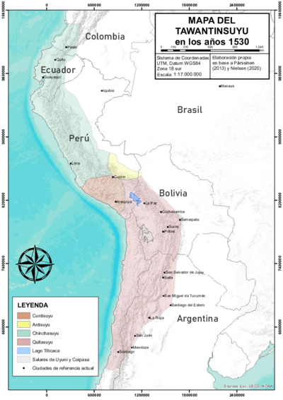
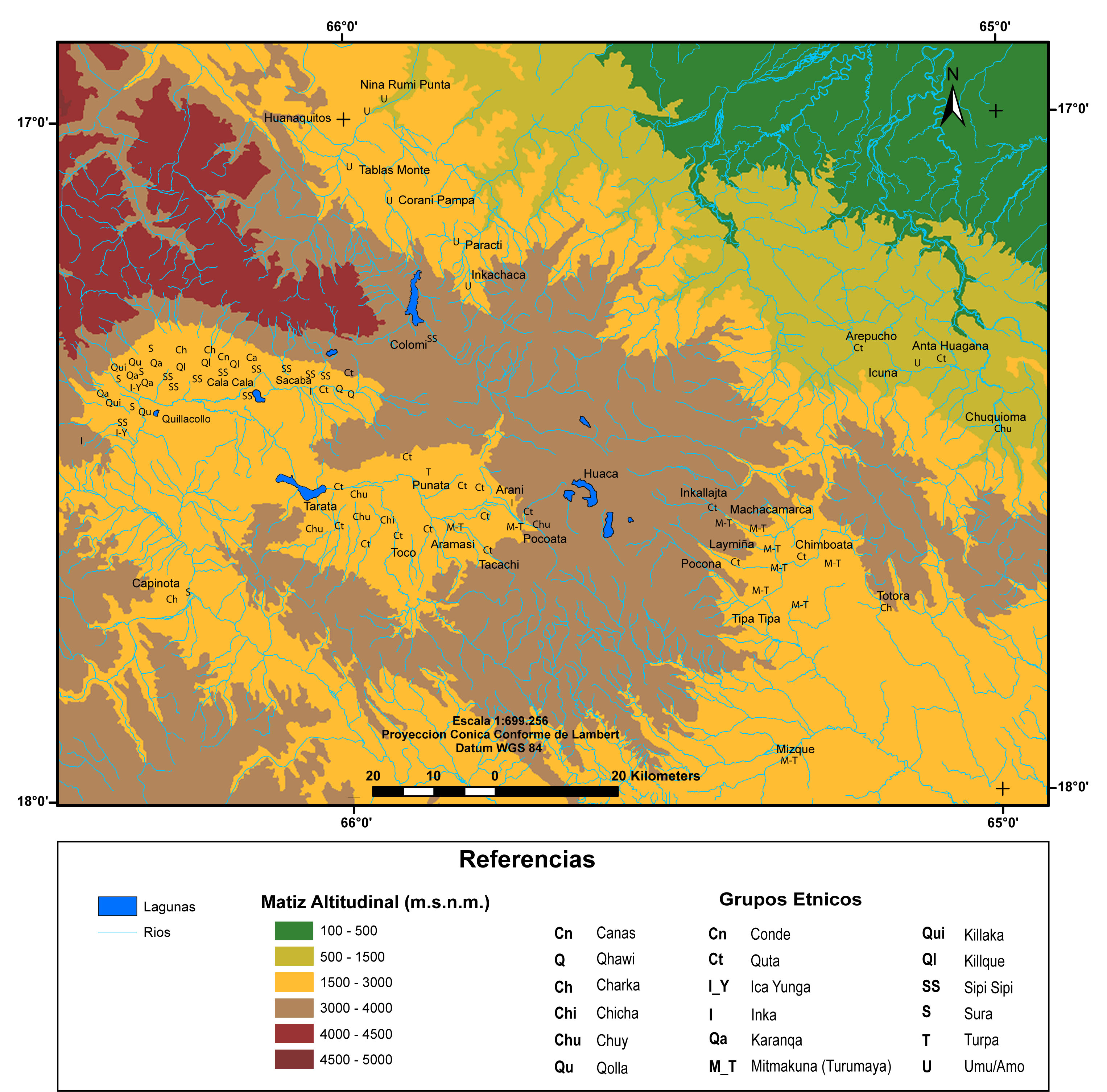
This map illustrates the multi-ethnic composition of the Central and Upper Valleys of present-day Cochabamba, Bolivia, as a result of Inca resettlement policies in the early 1500s.1 The so-called “valleys of Cochabamba” are three contiguous valleys (Lower, Central, and Upper) which, running west to east, form one large, fertile valley. Claiming these lands as state domains, the Incas transferred the autochthonous population further east and brought in groups from other districts of the Inca State, known as the Tawantinsuyu (see THE TAWANTINSUYU IN THE 1530s – TERRITORY OF THE INCA STATE ). Thus, the Incas turned this area of the Qullasuyu (see THE QULLASUYU IN THE 1530s – SOUTHERN DISTRICT OF THE INCA STATE ), the southern district of the Inca State, into a multi-ethnic territory governed directly by Inca officials.2

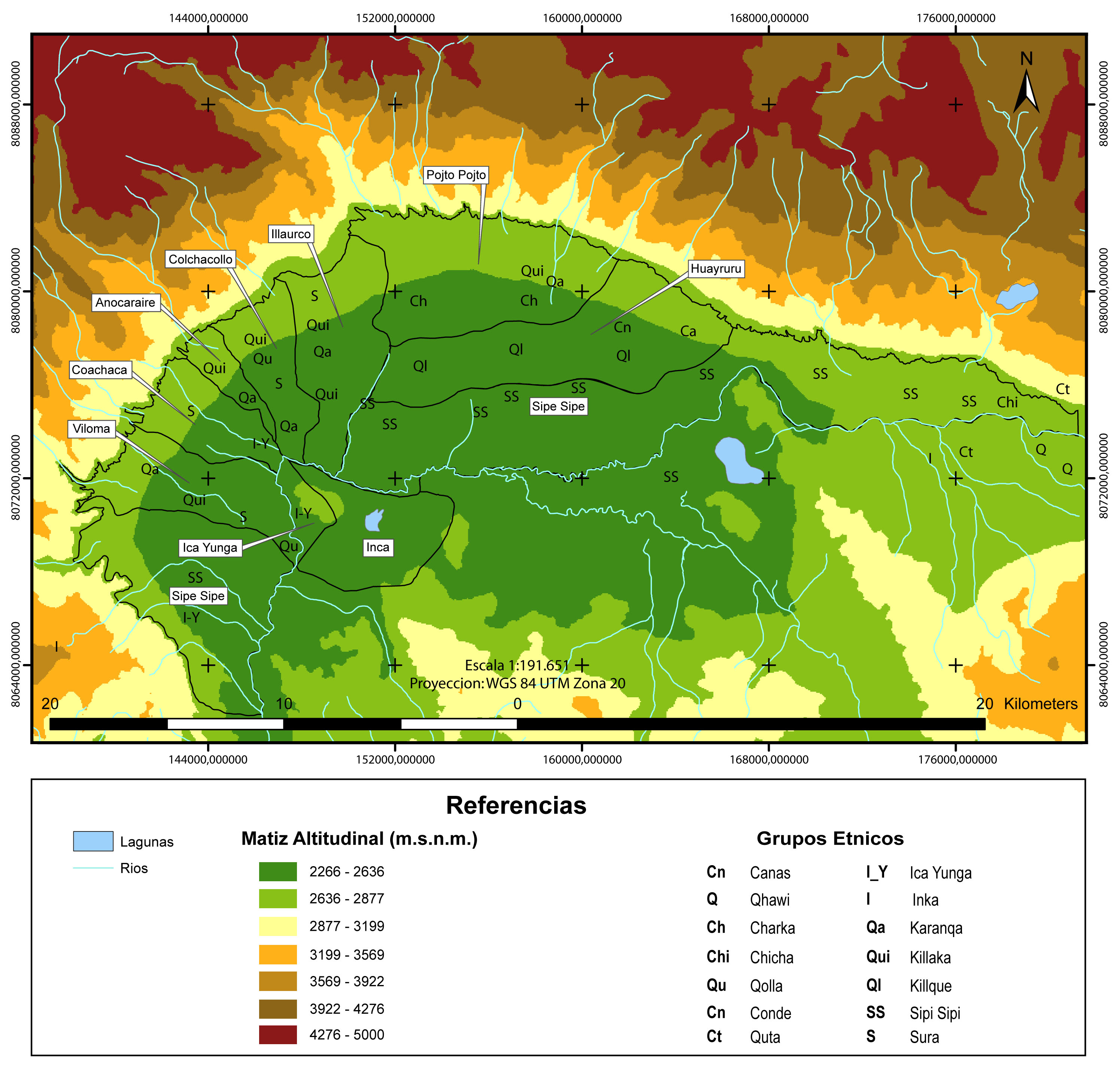
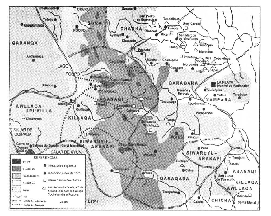
In the late 1400s, Sapa Inca Tupaq Yupanki (the Inca head of state) conquered the valleys of Cochabamba. The main native groups encountered in the Central and Upper valleys were the Sipesipes (or Sipi-Sipis), the Cotas (or Qutas), and the Chuyes (or Chuis). In an effort to consolidate Inca state control over these newly acquired territories, Tupaq Yupanki transferred part of the autochthonous population further southeast, where they were to guard the new eastern borders (see THE EASTERN BORDERS OF THE QULLASUYU - SOUTHERN DISTRICT OF THE INCA STATE - 16th CENTURY ) against the indomitable lowland chiefdoms of the Chiriguano (a name the Incas, and later the Spanish, used to refer to the Tupí-Guaraní people). While the Sipi-Sipis were mostly allowed to remain, large segments of the Quta and Chui populations were relocated to Inca fortresses in Pocona and Mizque along the eastern frontier.

Larger agrarian transformations occurred in the early 1500s, when Tupaq Yupanki’s son, Wayna Qhapaq, seized these valleys to “set up a state-owned ‘archipelago’ for the purpose of large-scale maize production, essentially for the use of the army.”3 The labor force for this vast enterprise was recruited from other areas of the Qullasuyu, mainly from the high-plateau Aymara polities (see AYMARA POLITIES of THE QULLASUYU in the 16th CENTURY ). According to testimonies recorded in colonial documents, 14,000 “Indians” were brought from “different nations,” and this figure, if accurate, indicates, “an undertaking of an unprecedented scope.”4 This contrasts sharply with other instances of state-owned archipelagos, which typically involved the resettlement of only 1,000 to 2,000 heads of household.5 Although data on the regional origins of these individuals is scarce and inconclusive, it seems certain that the 14,000 included both mitmaqkuna (people permanently resettled in the valley) and mitayos (people who rotated annually as part of the Inca labor tax system known as mit’a).

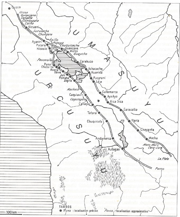
With the exception of a few small areas owned personally by Wayna Qhapaq, the lands seized in Cochabamba became part of the state domain. All fields were farmed by the mitmaqkuna and rotating mitayos, who were managed by their respective ethnic authorities, but they ultimately remained under the authority of two Inca governors. Workers were allotted certain fields for their own sustenance and were also permitted to farm the upper and lower margins of the Inca State fields. Some land was also given to ethnic authorities who were expected to practice “generosity” by redistributing the yields among those who cultivated it. Resettled mitmaqkuna and rotating mitayos also benefited from the Sapa Inca’s “generosity” and received maize from the Sapa Inca’s granaries. Apart from these redistributions, the maize produced in Cochabamba was collected at the storage center of Paria (situated on the high plateau along the Inca Road (see INCA ROADS AND TAMBOS in the 16th CENTURY )) and then transported to Cusco. The llama herders of the Suras (or Soras) (see THE AYMARA LORDSHIP OF THE SURAS IN THE 16TH CENTURY ) of Sipe-Sipe managed the transportation between the Cochabamba valleys and Paria and tended the herds belonging to the Inca State in Sipe-Sipe, located in the Lower Valley (see ).

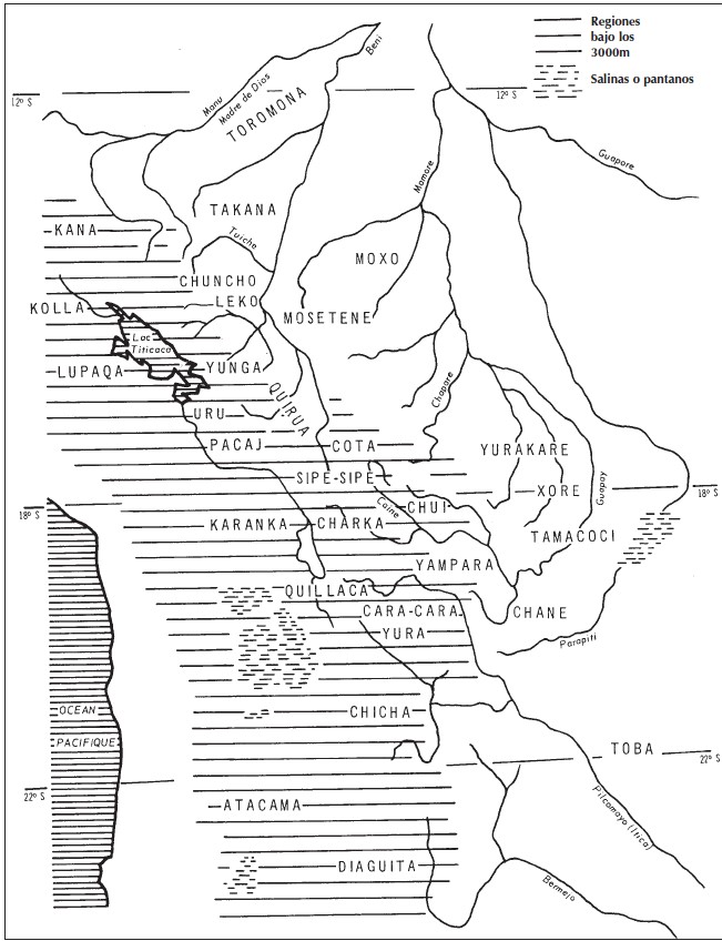
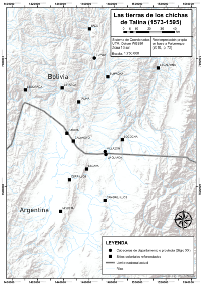
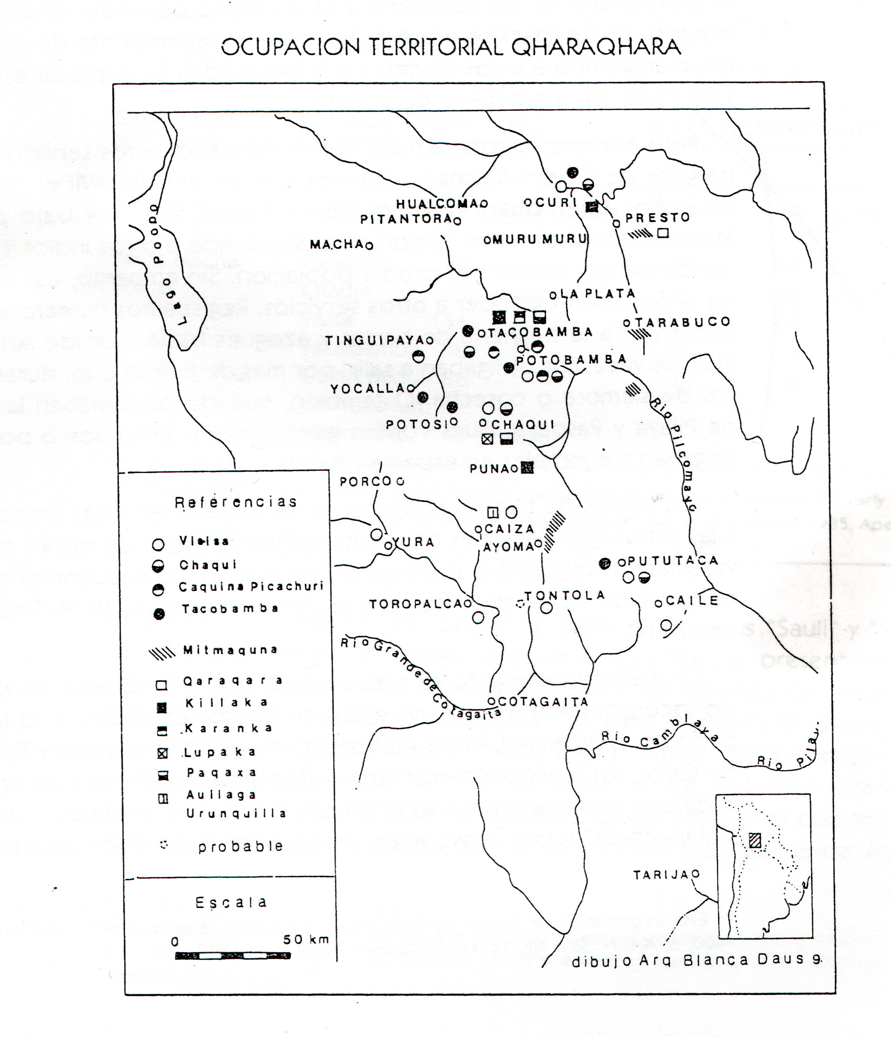
The Aymara polities rewarded with maize-cultivating colonies in the valleys of Cochabamba included the: Charkas (see AYMARA LORDSHIPS OF THE CHARKA AND NEIGHBORING NON-AYMARA POLITIES IN THE LATE 15th AND EARLY 16th CENTURIES ), Qaraqaras (see TERRITORY OF THE AYMARA LORDSHIP OF THE QARAQARA IN THE 16TH CENTURY ), Suras (see THE AYMARA LORDSHIP OF THE SURAS IN THE 16TH CENTURY ), Killakas (see TERRITORY OF THE AYMARA LORDSHIP OF THE KILLAKAS IN THE EARLY 16TH CENTURY ), Karanqas (see THE KARANQAS AYMARA POLITY - SNAPSHOT OF TRANS-BORDER CONNECTIONS AROUND 1900 (GOOGLE EARTH ADAPTATION) ), Chichas (see THE LANDS OF THE AYMARA LORDSHIP OF THE CHICHAS DE TALINA UNDER COLONIAL RULE IN THE LATE 16TH CENTURY ), Qullas, and Kanas (the Spanish spelling of these names in colonial documents and beyond is: Charcas, Caracaras, Soras, Quillacas, Carangas, Chichas, Collas, and Canas). The Urus—a non-Aymara ethnic group native to the high plateau—also had colonies in these valleys.

After the Spanish conquest, some Aymara mitmaqkunas and mitayos stationed in the valley territories returned to their homelands on the high plateau, potentially facing challenges such as property loss or diminished influence compared to their pre-conquest status. Some who remained in the valley managed to retain ties to their respective Aymara polities, while others did not. Over time, the majority of the Indigenous population of the valleys became Indigenous peasants subjected to the regime imposed by the owners of haciendas (large, privately owned estates).

In the current context of the Plurinational State of Bolivia, most of the Indigenous residents of the valleys of Cochabamba are Qhishwa speakers who generally identify as members of the Qhishwa (or Quechua) Nation.

REFERENCES:

Larson, Brooke. Colonialism and Agrarian Transformation in Bolivia: Cochabamba 1550–1900. Princeton: Princeton University Press, 1988.

Sánchez, Walter. “‘Indios buenos para la guerra’: Agencia (agency) local y presencia Inka en los valles de Cochabamba.” In Ocupación Inka y dinámicas regionales en los Andes (siglos XV–XVII), edited by Claudia Rivera Casanovas, 99–122. La Paz: IFEA and Plural editores, 2014.

Wachtel, Nathan. “The Mitimas of the Cochabamba Valley: The Colonization Policy of Huayna Capac.” In The Inca and Aztec States, 1400-1800: Anthropology and History, edited by George A. Collier, Renato I. Rosaldo, and John D. Wirth, 199–235. Cambridge, MA: Academic Press, 1982.


  1. Walter Sánchez, “‘Indios buenos para la guerra’: Agencia (agency) local y presencia Inka en los valles de Cochabamba,” in Ocupación Inka y dinámicas regionales en los Andes (siglos XV–XVII), ed. Claudia Rivera Casanovas (La Paz: IFEA and Plural editores, 2014), 99–122. ↩︎

  2. Brooke Larson, Colonialism and Agrarian Transformation in Bolivia: Cochabamba, 1550–1900. (Princeton: Princeton University Press, 1988), 20. ↩︎

  3. Nathan Wachtel, “The Mitimas of the Cochabamba Valley: The Colonization Policy of Huayna Capac,” in The Inca and Aztec States, 1400–1800: Anthropology and History, ed. George A. Collier, Renato I. Rosaldo, and John D. Wirth (Cambridge, MA: Academic Press, 1982), 199–235. ↩︎

  4. Wachtel, “The Mitimas of the Cochabamba Valley: The Colonization Policy of Huayna Capac,” 218. ↩︎

  5. Wachtel, “The Mitimas of the Cochabamba Valley: The Colonization Policy of Huayna Capac.” ↩︎

Citation

Medeiros, Carmen, Celina Grisi, and Radek Sánchez Patzy. 2024. 'MULTI-ETHNIC TERRITORY under INCA DIRECT RULE: THE CENTRAL AND UPPER VALLEYS OF COCHABAMBA in the 1530s'. Dispossessions in the Americas. https://staging.dia.upenn.edu/en/content/BOL0006Y/

  • Download Image

Reading in Spanish

Map Commentary 1530 - 1539

TERRITORIO MULTIÉTNICO bajo EL DOMINIO INCA DIRECTO: LOS VALLES CENTRAL Y SUPERIOR DE COCHABAMBA en la DÉCADA DE 1530

  • Medeiros, Carmen

  • Grisi, Celina

  • Sánchez Patzy, Radek

Published: 2024

  • Download Image
Sánchez Canedo, Walter. "Indios buenos para la guerra". Agencia (agency) local y presencia Inka en los valle de Cochabamba". En Rivera Casanovas, C. (ed), Ocupación Inka y dinámicas regionales en los Andes (siglos XV-XVII), La Paz, IFEA-Plural, 2014.

Sánchez Canedo, Walter. “Indios buenos para la guerra”. Agencia (agency) local y presencia Inka en los valle de Cochabamba". En Rivera Casanovas, C. (ed), Ocupación Inka y dinámicas regionales en los Andes (siglos XV-XVII), La Paz, IFEA-Plural, 2014.

  • Download Image

Reading in Portuguese

Map Commentary 1530 - 1539

TERRITÓRIO MULTIÉTNICO SOB O DOMÍNIO INCA: OS VALES CENTRAL E ALTO DE COCHABAMBA NA DÉCADA DE 1530

  • Medeiros, Carmen

  • Grisi, Celina

  • Sánchez Patzy, Radek

Published: 2024

  • Download Image
Sánchez Canedo, Walter. "Indios buenos para la guerra". Agencia (agency) local y presencia Inka en los valle de Cochabamba". En Rivera Casanovas, C. (ed), Ocupación Inka y dinámicas regionales en los Andes (siglos XV-XVII), La Paz, IFEA-Plural, 2014.

Sánchez Canedo, Walter. “Indios buenos para la guerra”. Agencia (agency) local y presencia Inka en los valle de Cochabamba". En Rivera Casanovas, C. (ed), Ocupación Inka y dinámicas regionales en los Andes (siglos XV-XVII), La Paz, IFEA-Plural, 2014.

Resumo

Este mapa ilustra a composição multiétnica dos vales central e alto da atual Cochabamba, Bolívia, como resultado das políticas de reassentamento incaicas no início do século XVI.1 Os chamados «vales de Cochabamba» são três vales contíguos (baixo, central e alto) que, de oeste a leste, formam um grande vale fértil. Os incas reclamaram estas terras como domínios do Estado, deslocaram a população nativa mais para o leste e trouxeram grupos de outros distritos do Estado inca, conhecido como o Tawantinsuyu. Assim, os incas transformaram esta zona do Qullasuyu, o distrito meridional do Estado inca, em um território multiétnico governado diretamente por funcionários incas.2

No final do século XV, el Sapa Inca Tupaq Yupanki (chefe do Estado inca) conquistou os vales de Cochabamba. Os principais grupos nativos que se encontravam nos vales central e alto eram os Sipesipes (ou Sipi-Sipis), os Cotas (ou Qutas) e os Chuyes (ou Chuis). Em um esforço por consolidar o controle do Estado inca sobre esses territórios recém adquiridos, Tupaq Yupanki mudou parte da população nativa para o sudeste, onde deviam proteger as novas fronteiras orientais contra as indomáveis lideranças das terras baixas dos chiriguanos (nome que os incas, e mais tarde os espanhóis, utilizaram para referir-se ao povo tupi-guarani). Enquanto a maioria dos sipi-sipi lhes foi permitido permanecer, grandes segmentos das populações quta e chui foram reassentados em fortalezas incas, em Pocona e Mizque, ao longo da fronteira oriental.

No início do século XVI grandes transformações agrárias ocorreram, quando o filho de Tupaq Yupanki, Wayna Qhapaq, apoderou-se desses vales para «estabelecer um “arquipélago” de propriedade estatal para a produção de milho em grande escala, essencialmente para o uso do exército».3 A mão de obra para esta vasta empresa foi recrutada em outras áreas do Qullasuyu, principalmente nas comunidades aimarás do altiplano. De acordo aos testemunhos registrados em documentos coloniais, 14.000 «índios» de «diferentes nações» foram trazidos. Se este número fosse exato, indicaria «uma empresa e um alcance sem precedentes».4 Isso diferencia muito de outros casos de arquipélagos estatais, que normalmente implicavam o reassentamento de entre 1000 e 2000 chefes de família.5 Apesar dos dados sobre a origem regional dessas pessoas serem escassos e pouco categóricos, parece seguro que os 14.000 incluíam tanto mitmaqkuna (pessoas reassentadas permanentemente no vale) como mitayos (pessoas que se revezavam anualmente, como parte do sistema incaico de impostos ao trabalho, conhecido como mit’a).

Excetuando algumas poucas áreas pequenas que pertenciam de forma pessoal a Wayna Qhapaq, as terras confiscadas em Cochabamba passaram a pertencer ao Estado. Todos os campos eram cultivados pelos mitmaqkuna e os mitayos rotativos, que eram administrados por suas respectivas autoridades étnicas, mas que, em última instância, permaneciam sob a autoridade de dois governadores incas. Certos campos eram alocados aos trabalhadores para seu próprio sustento e também tinham licença para cultivar as margens superiores e inferiores dos campos do Estado inca. Algumas terras foram concedidas às autoridades étnicas, das quais esperava-se que praticassem a «generosidade» redistribuindo as colheitas entre aqueles que as cultivavam. Os mitmaqkuna reassentados e os mitayos rotativos também se beneficiaram da «generosidade» do Sapa Inca e receberam milho dos celeiros do Sapa inca. Além destas redistribuições, o milho produzido em Cochabamba era guardado no centro de armazenamento de Paria (situado na meseta alta ao longo do Caminho inca) e posteriormente era transportado a Cuzco. Os pastores de lhamas dos Suras (ou Soras) de Sipe-Sipe se ocupavam do transporte entre os vales de Cochabamba e Paria e cuidavam dos rebanhos que pertenciam ao Estado inca em Sipe-Sipe, situado no vale baixo.

As pólis aimarás que foram recompensadas com colônias dedicadas ao cultivo do milho nos vales de Cochabamba incluíam: os Charkas, Qaraqaras,Suras, Killakas, Karanqas, Chichas, Qullas e Kanas (a ortografia espanhola desses nomes nos documentos coloniais e posteriores é: Charcas, Caracaras, Soras, Quillacas, Carangas, Chichas, Collas e Canas). Os urus, um grupo étnico não aimará originário do altiplano, também tinham colônias nesses vales.

Após a conquista espanhola, alguns mitmaqkunas e mitayos aimarás localizados nos territórios do vale voltaram a suas terras natais no altiplano, enfrentando-se potencialmente a desafios como a perda de propriedades ou a redução de sua influência em comparação com seu status anterior à conquista. Alguns dos que permaneceram no vale conseguiram manter os vínculos com suas respectivas comunidades aimarás, mas outros não puderam fazê-lo. Com o passar do tempo, a maior parte da população indígena dos vales se transformou em indígenas submetidos ao regime imposto pelos proprietários das fazendas (grandes estabelecimentos de propriedade privada).

No contexto atual do Estado Plurinacional da Bolívia, a maioria dos residentes indígenas dos vales de Cochabamba são falantes de qhishwa que geralmente se identificam como membros da nação qhishwa (ou quéchua).

REFERÊNCIAS:

Larson, Brooke. Colonialism and Agrarian Transformation in Bolivia: Cochabamba 1550–1900. Princeton: Princeton University Press, 1988.

Sánchez, Walter. «Indios buenos para la guerra: Agencia local y presencia inca en los valles de Cochabamba». Em Ocupación inca y dinámicas regionales en los Andes (siglos XV-XVII), editado por Claudia Rivera Casanovas, 99-122. La Paz: IFEA e Plural editores, 2014.

Wachtel, Nathan. «The Mitimas of the Cochabamba Valley: The Colonization Policy of Huayna Capac». Em The Inca and Aztec States, 1400-1800: Anthropology and History, editado por George A. Collier, Renato I. Rosaldo e John D. Wirth, 199–235. Cambridge, MA: Academic Press, 1982.


  1. Walter Sánchez, «Indios buenos para la guerra: Agencia local y presencia inca en los valles de Cochabamba», en Ocupación inca y dinámicas regionales en los Andes (siglos XV-XVII), ed. Claudia Rivera Casanovas (La Paz: IFEA e Plural editores, 2014), 99-122. ↩︎

  2. Brooke Larson, Colonialism and Agrarian Transformation in Bolivia: Cochabamba, 1550–1900 (Princeton: Princeton University Press, 1988), 20. ↩︎

  3. Nathan Wachtel, «The Mitimas of the Cochabamba Valley: The Colonization Policy of Huayna Capac», en The Inca and Aztec States, 1400–1800: Anthropology and History, ed. George A. Collier, Renato I. Rosaldo e John D. Wirth (Cambridge, MA: Academic Press, 1982), 199–235. ↩︎

  4. Wachtel, «Los mitimas del valle de Cochabamba: la política de colonización de Huayna Cápac», 218. ↩︎

  5. Wachtel, «Los mitimas del valle de Cochabamba: la política de colonización de Huayna Cápac». ↩︎

Citation

Medeiros, Carmen, Celina Grisi, and Radek Sánchez Patzy. 2024. 'TERRITÓRIO MULTIÉTNICO SOB O DOMÍNIO INCA: OS VALES CENTRAL E ALTO DE COCHABAMBA NA DÉCADA DE 1530'. Dispossessions in the Americas. https://staging.dia.upenn.edu/pt/content/BOL0006Y/

  • Download Image

Related Content

THE TAWANTINSUYU IN THE 1530s – TERRITORY OF THE INCA STATE

THE TAWANTINSUYU IN THE 1530s – TERRITORY OF THE INCA STATE

Map Commentary 1530 - 1539
THE QULLASUYU IN THE 1530s – SOUTHERN DISTRICT OF THE INCA STATE

THE QULLASUYU IN THE 1530s – SOUTHERN DISTRICT OF THE INCA STATE

Map Commentary 1530 - 1539
INCA ROADS AND TAMBOS in the 16th CENTURY

INCA ROADS AND TAMBOS in the 16th CENTURY

Map Commentary 1500 - 1599
THE EASTERN BORDERS OF THE QULLASUYU - SOUTHERN DISTRICT OF THE INCA STATE - 16th CENTURY

THE EASTERN BORDERS OF THE QULLASUYU - SOUTHERN DISTRICT OF THE INCA STATE - 16th CENTURY

Map Commentary 1500 - 1599
MULTI-ETHNIC TERRITORY under INCA DIRECT RULE: THE LOWER VALLEY OF COCHABAMBA in the 1530s

MULTI-ETHNIC TERRITORY under INCA DIRECT RULE: THE LOWER VALLEY OF COCHABAMBA in the 1530s

Map Commentary 1530 - 1539
THE LANDS OF THE AYMARA LORDSHIP OF THE CHICHAS DE TALINA UNDER COLONIAL RULE IN THE LATE 16TH CENTURY

THE LANDS OF THE AYMARA LORDSHIP OF THE CHICHAS DE TALINA UNDER COLONIAL RULE IN THE LATE 16TH CENTURY

Map Commentary 1573 - 1595
THE AYMARA LORDSHIP OF THE SURAS IN THE 16TH CENTURY

THE AYMARA LORDSHIP OF THE SURAS IN THE 16TH CENTURY

Map Commentary 1500 - 1599
AYMARA LORDSHIPS OF THE CHARKA AND NEIGHBORING NON-AYMARA POLITIES IN THE LATE 15th AND EARLY 16th CENTURIES

AYMARA LORDSHIPS OF THE CHARKA AND NEIGHBORING NON-AYMARA POLITIES IN THE LATE 15th AND EARLY 16th CENTURIES

Map Commentary 1500 - 1550
TERRITORY OF THE AYMARA LORDSHIP OF THE QARAQARA IN THE 16TH CENTURY

TERRITORY OF THE AYMARA LORDSHIP OF THE QARAQARA IN THE 16TH CENTURY

Map Commentary 1500 - 1599
TERRITORY OF THE AYMARA LORDSHIP OF THE KILLAKAS IN THE EARLY 16TH CENTURY

TERRITORY OF THE AYMARA LORDSHIP OF THE KILLAKAS IN THE EARLY 16TH CENTURY

Map Commentary 1500 - 1570
THE KARANQAS AYMARA POLITY - SNAPSHOT OF TRANS-BORDER CONNECTIONS AROUND 1900 (GOOGLE EARTH ADAPTATION)

THE KARANQAS AYMARA POLITY - SNAPSHOT OF TRANS-BORDER CONNECTIONS AROUND 1900 (GOOGLE EARTH ADAPTATION)

Map Commentary 1900

Dispossessions in the Americas

A project by

University of Pennsylvania

Copyright 2024

With support from

Mellon Foundation

Site design & development

Element 84

Art Credits

Sánchez Canedo, Walter. “Indios buenos para la guerra”. Agencia (agency) local y presencia Inka en los valle de Cochabamba". En Rivera Casanovas, C. (ed), Ocupación Inka y dinámicas regionales en los Andes (siglos XV-XVII), La Paz, IFEA-Plural, 2014.

Site Pages

  • Home
  • Explore
  • About
  • Authors
  • Art
  • Bodies
  • Curricula
  • Cultural Heritage
  • Maps
  • Territories