Dispossesions in the Americas

Dispossesions in the Americas

  • Home
  • Explore
  • About
  • Authors
  • Art
  • Bodies
  • Curricula
  • Cultural Heritage
  • Maps
  • Territories
Back to Explore
Map Commentary 1500 - 1599

THE EASTERN BORDERS OF THE QULLASUYU - SOUTHERN DISTRICT OF THE INCA STATE - 16th CENTURY

  • Medeiros, Carmen

  • Grisi, Celina

  • Sánchez Patzy, Radek

Published: 2024

  • Download Image
Renard Casevitz, F.M. Saignes, Thierry y A.C. Taylor. Al Este de los Andes Orientales. Relaciones entre las Sociedades Andinas y Amazonicas. Abya-Yala, 1988.

Renard Casevitz, F.M. Saignes, Thierry y A.C. Taylor. Al Este de los Andes Orientales. Relaciones entre las Sociedades Andinas y Amazonicas. Abya-Yala, 1988.

Abstract

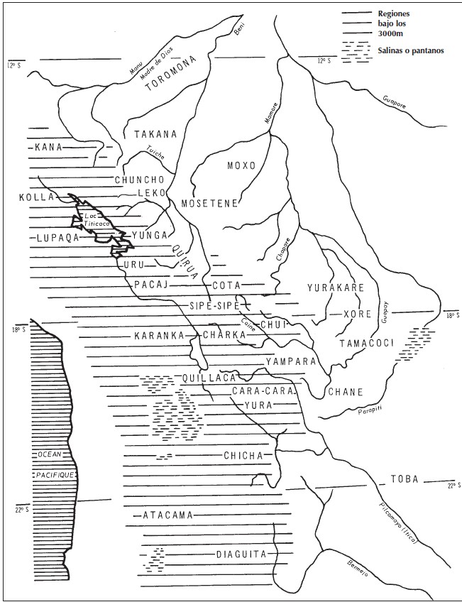
There is no consensus about the exact shape of the eastern borders of the Inca State, the Tawantinsuyu (see THE TAWANTINSUYU IN THE 1530s – TERRITORY OF THE INCA STATE ), but it is widely agreed that these borders were porous and unstable. This map, which depicts the southern district, the Qullasuyu (see THE QULLASUYU IN THE 1530s – SOUTHERN DISTRICT OF THE INCA STATE ), shows the Indigenous groups that inhabited this area in pre-Inca times, allowing us to identify those groups that lived along the eastern borders and interacted with the Inca State in various ways—through exchanges, warfare, alliances, etc.—but were never fully incorporated into it. The Indigenous groups shown to the far right of the lined area of the map were never conquered by the Incas (or by the Spanish) and include the: Toromona, Takana, Chuncho, Leko, Moxo, Mosetene, Yurakare, Xone, Tomococi, Chane, and Toba. All these groups were non-state societies that lived either in the tropical piedmont and plains of the Amazonian Basin or the drier, subtropical piedmont and plains of the Chaco region. It is worth noting that the word “chuncho” was often used as a generic term to describe all non-state societies living in the tropical piedmont and Amazonian plains.

The map’s legend is somewhat confusing, as it suggests that the lined areas represent regions below 3,000 meters in elevation—even though Lake Titicaca, depicted within the lined section, is actually located at 3,810 meters above sea level. It seems more likely that the lined areas actually represent regions above 3,000 meters. In any case, these areas roughly correspond to the territory of the Qullasuyu.

The expansion of the Inca State transformed the geography and human landscape of this vast territory in multiple ways. While Inca expansion north of Cusco stopped at the piedmont, south of Cusco it extended further down into the plains of the Amazonian basin and the Chaco region. The main strategy used by the Incas to expand this eastern border was to establish multi-ethnic colonies (see MULTI-ETHNIC TERRITORY under INCA DIRECT RULE: THE CENTRAL AND UPPER VALLEYS OF COCHABAMBA in the 1530s and MULTI-ETHNIC TERRITORY under INCA DIRECT RULE: THE LOWER VALLEY OF COCHABAMBA in the 1530s ) of people resettled from other regions of the Inca State. Through this resettlement strategy, the Incas created a buffer zone between Andean ethnic groups that occupied the edges of the piedmont (who were part of Tawantinsuyu) and non-Andean groups that remained outside the Inca State. This buffer zone policy suggests that by “occupying this intermediate no-man’s land, the Inca wanted to prevent direct communication between border neighbors” (own translation).1 Thus, we can visualize the eastern border of the Qullasuyu as a zigzag line running south through the piedmont, with inroads into the lower plains, dotted with Inca fortresses and multi-ethnic settlements.

Another significant event that altered the human geography shown on this map was the arrival of the Tupí-Guaraní people in the plains and piedmont of the Chaco region (between the Guapay and Pilcomayo rivers; 18°S – 20°S on the map) in the late 1400s and early 1500s, just before the Spanish conquest. Coming from what is now Paraguay and referred to as Chiriguanos by the Incas (and later by the Spanish), the Guaraní people posed a major threat to this southeastern border.

REFERENCES:

Renard-Casevitz, France Marie, Thierry Saignes, and A. C. Taylor. Al este de los Andes: Relaciones entre las sociedades amazónicas y andinas entre los siglos XV y XVI. Lima: ABYA YALA and IFEA, 1988.


  1. France Marie Renard-Casevitz, et al., Al Este de los Andes: Relaciones entre las Sociedades Amazónicas y Andinas entre los Siglos XV y XVI (Lima: ABYA YALA and IFEA, 1988), 113. ↩︎

Citation

Medeiros, Carmen, Celina Grisi, and Radek Sánchez Patzy. 2024. 'THE EASTERN BORDERS OF THE QULLASUYU - SOUTHERN DISTRICT OF THE INCA STATE - 16th CENTURY'. Dispossessions in the Americas. https://staging.dia.upenn.edu/en/content/BOL0005Y/

  • Download Image

Reading in Spanish

Map Commentary 1500 - 1599

LAS FRONTERAS ORIENTALES DEL QULLASUYU – DISTRITO SUR DEL ESTADO INCA – SIGLO XVI

  • Medeiros, Carmen

  • Grisi, Celina

  • Sánchez Patzy, Radek

Published: 2024

  • Download Image
Renard Casevitz, F.M. Saignes, Thierry y A.C. Taylor. Al Este de los Andes Orientales. Relaciones entre las Sociedades Andinas y Amazonicas. Abya-Yala, 1988.

Renard Casevitz, F.M. Saignes, Thierry y A.C. Taylor. Al Este de los Andes Orientales. Relaciones entre las Sociedades Andinas y Amazonicas. Abya-Yala, 1988.

  • Download Image

Reading in Portuguese

Map Commentary 1500 - 1599

AS FRONTEIRAS ORIENTAIS DO QULLASUYU - DISTRITO SUL DO ESTADO INCA – SÉCULO XVI

  • Medeiros, Carmen

  • Grisi, Celina

  • Sánchez Patzy, Radek

Published: 2024

  • Download Image
Renard Casevitz, F.M. Saignes, Thierry y A.C. Taylor. Al Este de los Andes Orientales. Relaciones entre las Sociedades Andinas y Amazonicas. Abya-Yala, 1988.

Renard Casevitz, F.M. Saignes, Thierry y A.C. Taylor. Al Este de los Andes Orientales. Relaciones entre las Sociedades Andinas y Amazonicas. Abya-Yala, 1988.

Resumo

Não há consenso sobre a forma exata das fronteiras orientais do Estado inca, o Tawantinsuyu, mas existe amplo acordo em relação a que estas fronteiras eram porosas e instáveis. Este mapa, que representa o distrito sul, o Qullasuyu, e mostra os grupos indígenas que habitavam nesta região geográfica na época pré-incaica, permitindo identificar os grupos estabelecidos ao longo das fronteiras orientais e que interagiam com o Estado inca de diversas maneiras - trocas, guerras, alianças, etc.-, mas que nunca se incorporaram plenamente ao Estado. Os grupos indígenas situados no extremo direito da área listrada do mapa nunca foram conquistados pelos incas (nem pelos espanhóis) e incluem os toromona, takana, chuncho, leko, moxo, mosetene, yurakare, xone, tomococi, chane e toba. Todos esses grupos eram sociedades que não faziam parte do Estado e que habitavam no sopé tropical e nas planícies da bacia amazônica ou no sopé subtropical mais seco e nas planícies da região do Chaco. É preciso indicar que a palavra «chuncho» era utilizada com frequência como termo genérico para descrever a totalidade das sociedades não estatais que habitavam no sopé tropical e nas planícies amazônicas.

A legenda do mapa é algo confusa, já que sugere que as zonas listradas representam regiões localizadas a menos de 3000 metros de altitude, embora o lago Titicaca, representado dentro da seção listrada, se encontre, na verdade, a 3810 metros acima do nível do mar. Parece mais provável que as zonas listradas representem áreas que estão acima dos 3000 metros. Seja como for, estas áreas correspondem aproximadamente ao território do Qullasuyu.

A expansão do Estado inca transformou a geografia e a paisagem humana deste vasto território de múltiplas formas. A expansão inca ao norte de Cusco se deteve nos contrafortes, ao sul de Cusco se estendeu mais longe, em direção às planícies da bacia amazônica e da região do Chaco. A principal estratégia utilizada pelos incas para expandir esta fronteira oriental foi estabelecer colônias multiétnicas de pessoas reassentadas desde outras regiões do Estado inca. Através desta estratégia de reassentamento, os incas criaram uma zona de atenuação entre os grupos étnicos andinos que ocupavam as bordas dos contrafortes (que faziam parte do Tawantinsuyu) e os grupos não andinos que permaneciam fora do Estado inca. Esta política de zona de atenuação sugere que, ao «ocupar esta terra de ninguém, intermediária, os incas queriam impedir a comunicação direta entre os vizinhos fronteiriços» (tradução própria).1 Assim, podemos visualizar a fronteira oriental do Qullasuyu como uma linha em zigue-zague que se estende para o sul através do sopé, com incursões nas planícies baixas, salpicadas de fortalezas incas e assentamentos multiétnicos.

Outro acontecimento significativo que alterou a geografia humana mostrada neste mapa foi a chegada do povo tupi-guarani às planícies e ao sopé da região do Chaco (entre os rios Guapay e Pilcomayo; 18°S - 20°S no mapa) em finais do século XV e início do século XVI, pouco antes da conquista espanhola. Originários do que atualmente é o Paraguai, e chamados chiriguanos pelos incas (e mais tarde pelos espanhóis), o povo guarani foi uma ameaça importante para a fronteira sudeste.

REFERÊNCIA:

Renard-Casevitz, France Marie, Thierry Saignes y A. C. Taylor. Al este de los Andes: Relaciones entre las sociedades amazónicas y andinas entre los siglos XV y XVI. Lima: ABYA YALA e IFEA, 1988.


  1. France Marie Renard-Casevitz, et al., Al Este de los Andes: Relaciones entre las Sociedades Amazónicas y Andinas entre los Siglos XV y XVI (Lima: ABYA YALA e IFEA, 1988), 113. ↩︎

Citation

Medeiros, Carmen, Celina Grisi, and Radek Sánchez Patzy. 2024. 'AS FRONTEIRAS ORIENTAIS DO QULLASUYU - DISTRITO SUL DO ESTADO INCA – SÉCULO XVI'. Dispossessions in the Americas. https://staging.dia.upenn.edu/pt/content/BOL0005Y/

  • Download Image

Related Content

THE TAWANTINSUYU IN THE 1530s – TERRITORY OF THE INCA STATE

THE TAWANTINSUYU IN THE 1530s – TERRITORY OF THE INCA STATE

Map Commentary 1530 - 1539
THE QULLASUYU IN THE 1530s – SOUTHERN DISTRICT OF THE INCA STATE

THE QULLASUYU IN THE 1530s – SOUTHERN DISTRICT OF THE INCA STATE

Map Commentary 1530 - 1539
MULTI-ETHNIC TERRITORY under INCA DIRECT RULE: THE CENTRAL AND UPPER VALLEYS OF COCHABAMBA in the 1530s

MULTI-ETHNIC TERRITORY under INCA DIRECT RULE: THE CENTRAL AND UPPER VALLEYS OF COCHABAMBA in the 1530s

Map Commentary 1530 - 1539
MULTI-ETHNIC TERRITORY under INCA DIRECT RULE: THE LOWER VALLEY OF COCHABAMBA in the 1530s

MULTI-ETHNIC TERRITORY under INCA DIRECT RULE: THE LOWER VALLEY OF COCHABAMBA in the 1530s

Map Commentary 1530 - 1539

Dispossessions in the Americas

A project by

University of Pennsylvania

Copyright 2024

With support from

Mellon Foundation

Site design & development

Element 84

Art Credits

Renard Casevitz, F.M. Saignes, Thierry y A.C. Taylor. Al Este de los Andes Orientales. Relaciones entre las Sociedades Andinas y Amazonicas. Abya-Yala, 1988.

Site Pages

  • Home
  • Explore
  • About
  • Authors
  • Art
  • Bodies
  • Curricula
  • Cultural Heritage
  • Maps
  • Territories