Dispossesions in the Americas

Dispossesions in the Americas

  • Home
  • Explore
  • About
  • Authors
  • Art
  • Bodies
  • Curricula
  • Cultural Heritage
  • Maps
  • Territories
Back to Explore
Map Commentary 1530 - 1539

THE TAWANTINSUYU IN THE 1530s – TERRITORY OF THE INCA STATE

  • Medeiros, Carmen

  • Grisi, Celina

  • Sánchez Patzy, Radek

Published: 2024

  • Download Image
Sánchez Patzy, elaboración propia, 2022, basada en Pärssinen (2013), Nielsen (2020)

Sánchez Patzy, elaboración propia, 2022, basada en Pärssinen (2013), Nielsen (2020)

Abstract

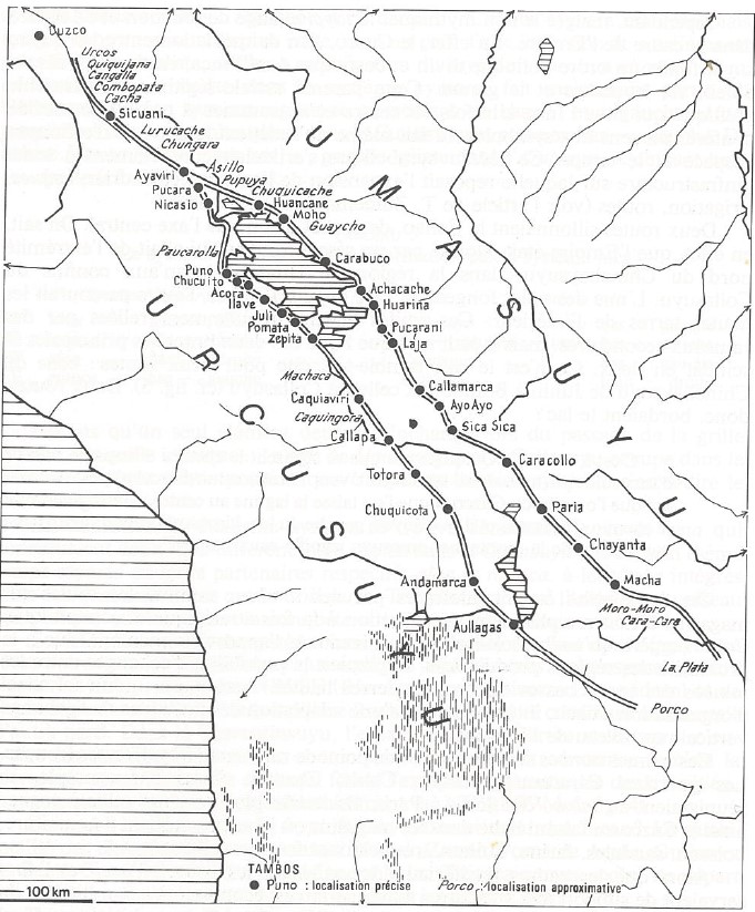
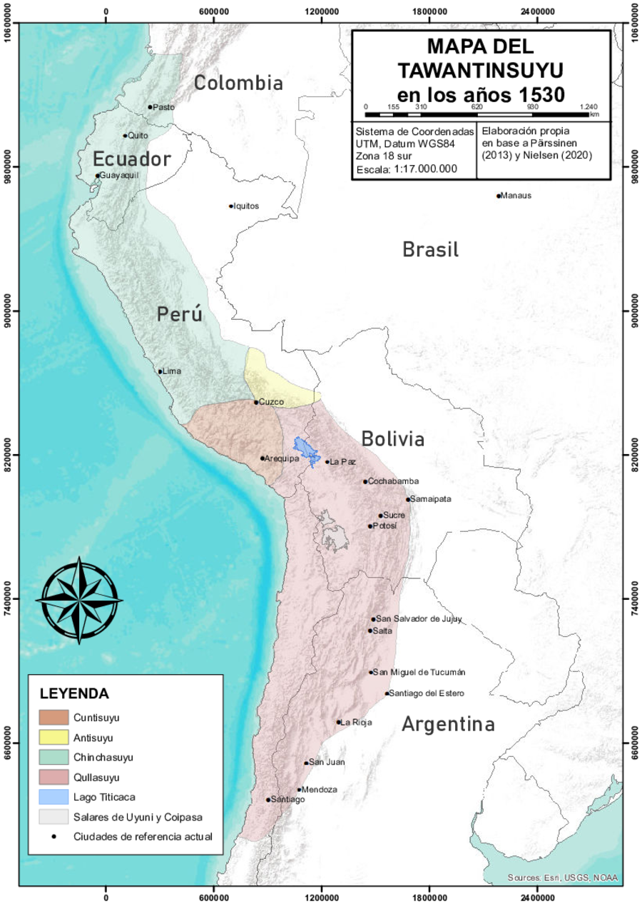
Layered over a Google Earth map and drawing from historical and archaeological data, this map offers a rough approximation of the territory of the Tawantinsuyu, i.e., the Inca State, at the time of the Spanish conquest.1 Located within the Central Andean region, this territory extended from present-day southern Colombia all the way southwards to present-day northern Argentina, encompassing the highlands of Ecuador, Peru, and Bolivia, the northern region of Chile and the northwestern region of Argentina. The Inca State was divided into four large districts, or suyus (in Qhishwa, the language of the Incas still spoken in most parts of this territory, tawa means four and suyu could be translated as district or region): Cuntisuyu, Antisuyu, Chinchasuyu, and Qullasuyu (see THE QULLASUYU IN THE 1530s – SOUTHERN DISTRICT OF THE INCA STATE ). There is no consensus on the boundaries of the eastern border, which was porous and unstable, nor on the exact shape of the Antisuyu. Likewise, there is no clear agreement on the internal borders between the four suyus, although it is increasingly acknowledged that they all originated in Cusco, the main center or capital of the Inca State. This vast territory was unified by a complex system of Inca roads (see INCA ROADS AND TAMBOS in the 16th CENTURY ) connecting numerous administrative centers.

The Incas ruled over this vast multi-ethnic territory through a combination of indirect and direct rule. Often represented as a pyramid, the political-administrative organization of the state had the Sapa Inca (the Inca head of state) at the top, immediately below the prefects of the four large districts, and below them the governors who were also members of the Inca nobility. At the lower echelons of the administrative hierarchy were non-Inca local authorities, such as lords of the conquered polities and chiefs of relocated multi-ethnic groups. The Incas sought the loyalty of these local authorities through gifts, marriage, indoctrination, and privileged access to land and labor. Articulating the Inca and non-Inca levels of administration was a vast bureaucracy of inspectors, census takers, tribute collectors and other state officials who preserved the internal order and ensured that tribute obligations were met satisfactorily.

There were two kinds of labor taxes imposed by the Inca State. One, known as mit’a, consisted of a specific number of days of labor in public works, in personal service to state officials, or in the army. The other type consisted of agricultural or pastoral work in the fields or with the herds belonging to the state, the Sapa Inca, or other members of his lineage (panaqa).

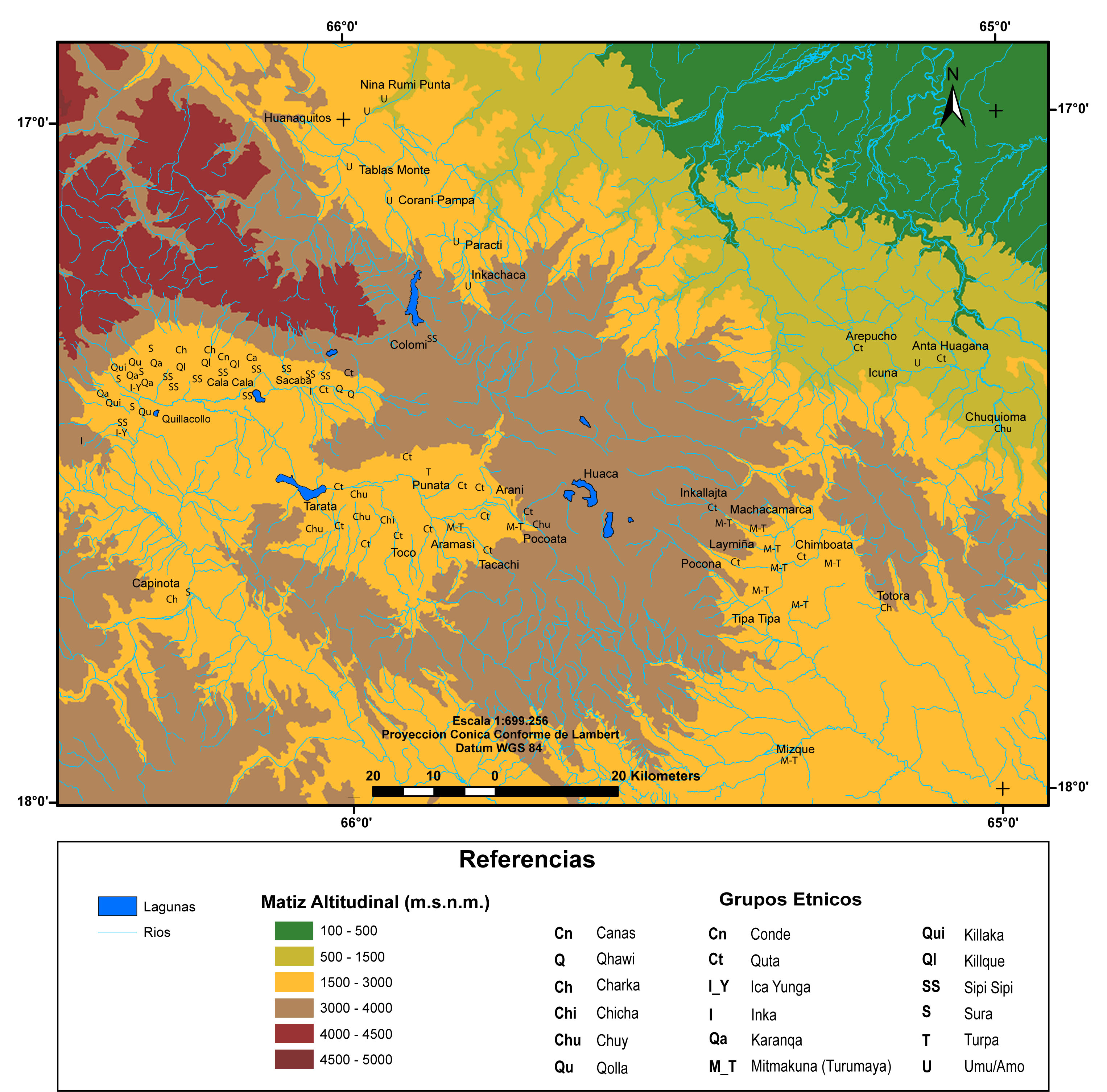
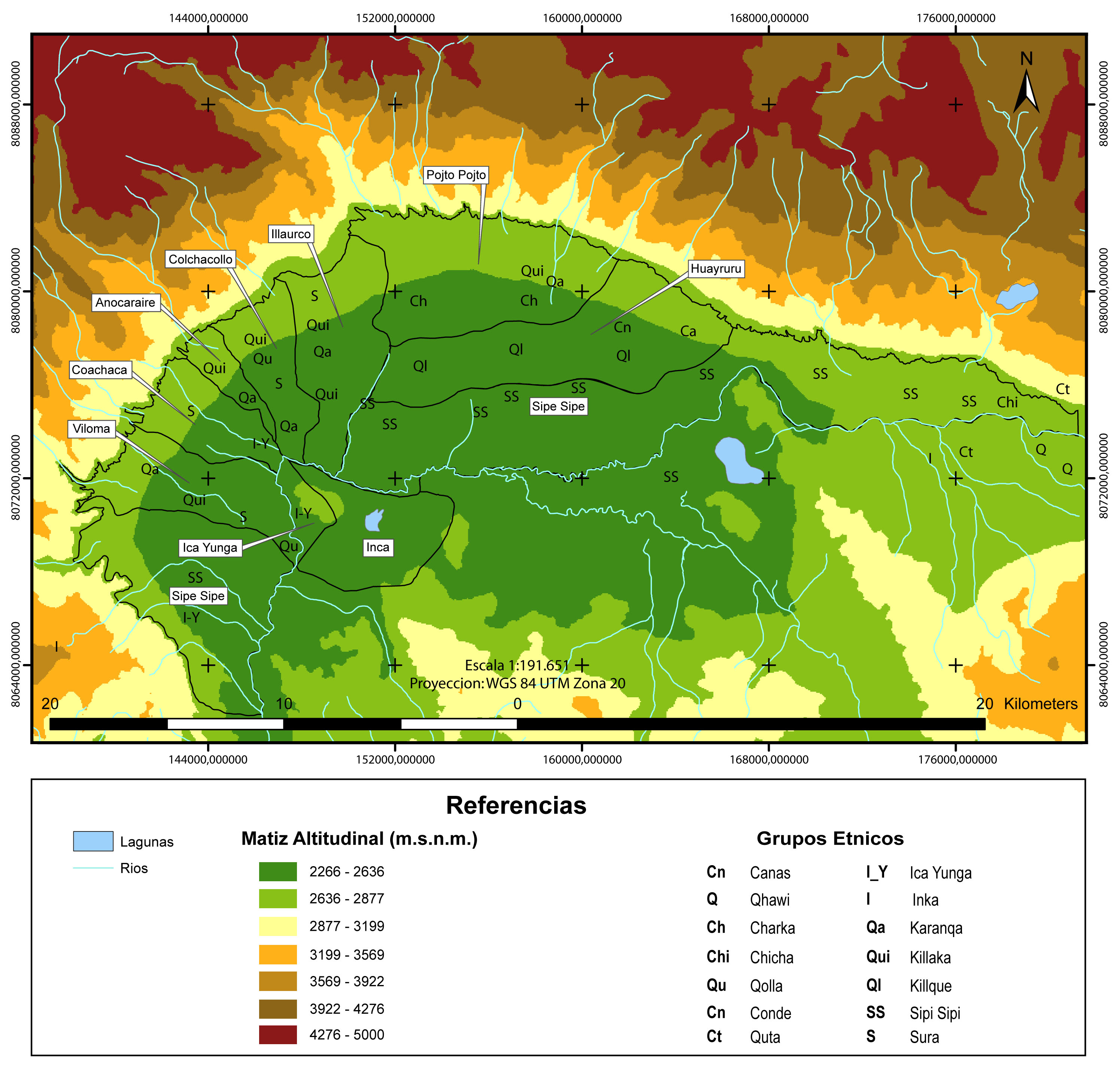
Building on the model of “vertical control of ecological tiers” (see AYMARA POLITIES of THE QULLASUYU in the 16th CENTURY ), the Incas implemented significant resettlement policies to defend their expanding frontiers and increase agricultural production for the state.2 By strategically relocating populations across different ecological zones, the Inca State aimed to optimize resource management and strengthen its control over the territory. Breaking up hostile ethnic groups and rewarding loyal ones with access to new valley lands, the Incas relocated large segments of population to different and sometimes very distant areas, thereby changing the ethnic composition of the conquered territories. Resettled populations, called mitmaqkuna (or mitimaes in Spanish colonial records) formed multi-ethnic colonies (see MULTI-ETHNIC TERRITORY under INCA DIRECT RULE: THE CENTRAL AND UPPER VALLEYS OF COCHABAMBA in the 1530s and MULTI-ETHNIC TERRITORY under INCA DIRECT RULE: THE LOWER VALLEY OF COCHABAMBA in the 1530s ) and retained, in principle, their ethnic ties with their native communities. In practice, however, they were under direct supervision of state officials and administrators. The specific situations varied greatly in the different areas of the state.

In sum, when the Spaniards embarked on their conquest of the Tawantinsuyu in the 1530s, they encountered a rich tapestry of diverse peoples integrated into a complex state society spread across a vast territory. The human landscape the Spaniards found was a result of the organizational structure and population management strategies implemented by the Inca State. During the initial stages of Spanish colonization, the Spanish colonial state would take advantage of some Inca state institutions, co-opting, re-signifying, and redirecting them to very different ends.

REFERENCES:

D’Altroy, Terence. The Incas. Oxford: Blackwell Publishing, 2002.

Larson, Brooke. Colonialism and Agrarian Transformation in Bolivia: Cochabamba 1550–1900. Princeton: Princeton University Press, 1988.

Murra, John. Formaciones económicas y políticas del mundo andino. Lima: Instituto de Estudios Peruanos, 1975.

Nielsen, Axel. “El Tawantinsuyu: Cosmología, economía y organización política.” In Camino ancestral Qhapaq Ñan. Una vía de integración de los Andes en Argentina, edited by Victoria Sosa, 24–52. Buenos Aires: Ministerio de Cultura de la Nación, Secretaría de Patrimonio Cultural, 2020.

Pärssinen, Martti. Tawantinsuyu: The Inca State and Its Political Organization. Helsinki: Suomen Historiallinen Seura, 1992.

Patterson, Thomas. The Inca Empire: Formation and Disintegration of a Pre-capitalist State. New York: Berg Publishers, 1997.

Spalding, Karen. Huarochirí: An Andean Society under Inca and Spanish Rule. Stanford: Stanford University Press, 1984.

Stern, Steve. Peru’s Indian Peoples and the Challenge of Spanish Conquest: Huamanga to 1640. Madison: The University of Wisconsin Press, 1982.


  1. Terence D’Altroy, The Incas (Oxford: Blackwell Publishing, 2002), 88; Axel Nielsen, “El Tawantinsuyu: Cosmología, economía y organización política,” in Camino ancestral Qhapaq Ñan: Una vía de integración de los Andes en Argentina, ed. Victoria Sosa (Buenos Aires: Ministerio de Cultura de la Nación, Secretaría de Patrimonio Cultural, 2020), 40; Martti Pärsinnen, Tawantinsuyu: The Inca State and Its Political Organization. (Helsinki: Suomen Historiallinen Seura, 1992). ↩︎

  2. John Murra, Formaciones económicas y políticas del mundo andino (Lima: Instituto de Estudios Peruanos, 1975). ↩︎

Citation

Medeiros, Carmen, Celina Grisi, and Radek Sánchez Patzy. 2024. 'THE TAWANTINSUYU IN THE 1530s – TERRITORY OF THE INCA STATE'. Dispossessions in the Americas. https://staging.dia.upenn.edu/en/content/BOL0001Y/

  • Download Image

Reading in Spanish

Map Commentary 1530 - 1539

EL TAWANTINSUYU EN LA DÉCADA DE 1530 – TERRITORIO DEL ESTADO INCA

  • Medeiros, Carmen

  • Grisi, Celina

  • Sánchez Patzy, Radek

Published: 2024

  • Download Image
Sánchez Patzy, elaboración propia, 2022, basada en Pärssinen (2013), Nielsen (2020)

Sánchez Patzy, elaboración propia, 2022, basada en Pärssinen (2013), Nielsen (2020)

  • Download Image

Reading in Portuguese

Map Commentary 1530 - 1539

TAWANTINSUYU NA DÉCADA DE 1530 – TERRITÓRIO DO IMPÉRIO INCA

  • Medeiros, Carmen

  • Grisi, Celina

  • Sánchez Patzy, Radek

Published: 2024

BOL0001Y: No image found

BOL0001Y

TAWANTINSUYU NA DÉCADA DE 1530 – TERRITÓRIO DO IMPÉRIO INCA

Carmen Medeiros, Celina Grisi, and Radek Sánchez

[XXX: insert BOL0001 as leading image for this narrative]

Sobreposto a um mapa do Google Earth e com base em dados históricos e arqueológicos, esse mapa oferece uma estimativa do território do Tawantinsuyu, isto é, o Império Inca, no período da conquista espanhola.1 Localizado na região central dos Andes, esse território se estendia desde o sul da atual Colômbia até o norte da atual Argentina, incluindo as terras altas do Equador, Peru e Bolívia, o norte do Chile e o noroeste da Argentina. O Império Inca era dividido entre quatro grandes distritos, ou suyus (em Qhishwa, a língua dos Incas, ainda falada na maior parte desse território, tawa significa quatro e suyu poderia ser traduzido como distrito ou região): Cuntisuyu, Antisuyu, Chinchasuyu, e Qullasuyu [XXX link to BOL0002Y]. Não há um consenso sobre os limites da fronteira leste, que era porosa e instável, nem sobre a forma exata do Antisuyu. Da mesma forma, não há um acordo claro sobre as fronteiras internas entre os suyus, embora seja cada vez mais reconhecido que todos eles se originaram em Cusco, o centro principal ou capital do Império Inca. Esse território vasto foi unificado por um complexo sistema de estradas incas [XXX link to BOL0004Y] que conectava diversos centros administrativos.

[LEIA MAIS]

Os Incas governaram esse vasto território multiétnico combinando formas diretas e indiretas de governo. Frequentemente representada como uma pirâmide, a organização política-administrativa do Estado tinha o Sapa Inca (o chefe de estado Inca) no topo, logo abaixo os administradores dos quatro grandes distritos, e abaixo deles as autoridades regionais que também eram membros da nobreza Inca. Nos níveis inferiores da hierarquia administrativa, estavam as autoridades locais não Incas, como os senhores dos povos conquistados e os chefes de grupos multiétnicos deslocados. Os Incas buscavam a lealdade dessas autoridades locais através de presentes, casamentos, assimilação cultural, e acesso privilegiado à terra e à mão de obra. Articulando os níveis de administração Incas e não Incas, havia uma vasta burocracia dos inspetores, recenseadores, cobradores de tributos e outros funcionários do Estado que preservavam a ordem interna e asseguravam que as obrigações tributárias fossem devidamente cumpridas.

Existiam dois tipos de formas de tributo de trabalho cobrados pelo Estado Inca. O primeiro, conhecido como mit’a, consistia em um número determinado de dias de trabalho em obras públicas, em serviços pessoais para funcionários do Estado ou no exército. O outro tipo consistia em trabalho agrícola ou pastoril nas terras ou nos rebanhos pertencentes ao Estado, ao Sapa Inca, ou a outros membros de sua linhagem (panaqa).

Com base no modelo de “controle vertical dos pisos ecológicos” [XXX link to BOL0003Y], os Incas implementaram importantes políticas de reassentamento para proteger as fronteiras em expansão e aumentar a produção agrícola para o Estado.2 Ao mover estrategicamente populações em diferentes zonas ecológicas, o Império Inca visava otimizar o gerenciamento de recursos e fortalecer seu controle sobre o território. Ao dispensar grupos étnicos hostis e favorecer os grupos leais com acesso a novos vales, os Incas realocavam grandes segmentos populacionais para áreas diferentes, e às vezes muito distantes, modificando assim a composição étnica dos territórios conquistados. As populações reassentadas, chamadas de mitmaqkuna (ou mitimaes nos registros coloniais espanhóis) formavam colônias multiétnicas [XXX link to BOL0006Y and BOL0007Y] e mantinham, ao menos em teoria, seus vínculos étnicos com as comunidades nativas. Porém, na prática, elas estavam sob supervisão direta de funcionários e administradores do Estado. As condições variavam muito de uma região para outra.

Em suma, quando os espanhóis iniciaram a conquista do Tawantinsuyu, na década de 1530, eles se depararam com um verdadeiro mosaico de povos distintos integrados a uma sociedade estatal complexa que se estendia sobre um vasto território. A paisagem humana que os espanhóis encontraram foi um resultado das formas de organização e das estratégias de gestão populacional adotadas pelo Império Inca. Durante os estágios iniciais da colonização espanhola, o Estado colonizador espanhol se aproveitou de algumas instituições Incas, cooptando-as, ressignificando-as e redirecionando-as para objetivos muito diferentes.

REFERÊNCIAS:

D’Altroy, Terence. The Incas. Oxford: Blackwell Publishing, 2002.

Larson, Brooke. Colonialism and Agrarian Transformation in Bolivia: Cochabamba 1550–1900. Princeton: Princeton University Press, 1988.

Murra, John. Formaciones económicas y políticas del mundo andino. Lima: Instituto de Estudios Peruanos, 1975.

Nielsen, Axel. “El Tawantinsuyu: Cosmología, economía y organización política.” In Camino ancestral Qhapaq Ñan. Una vía de integración de los Andes en Argentina, edited by Victoria Sosa, 24–52. Buenos Aires: Ministerio de Cultura de la Nación, Secretaría de Patrimonio Cultural, 2020.

Pärssinen, Martti. Tawantinsuyu: The Inca State and Its Political Organization. Helsinki: Suomen Historiallinen Seura, 1992.

Patterson, Thomas. The Inca Empire: Formation and Disintegration of a Pre-capitalist State. New York: Berg Publishers, 1997.

Spalding, Karen. Huarochirí: An Andean Society under Inca and Spanish Rule. Stanford: Stanford University Press, 1984.

Stern, Steve. Peru’s Indian Peoples and the Challenge of Spanish Conquest: Huamanga to 1640. Madison: The University of Wisconsin Press, 1982.


  1. Terence D’Altroy, The Incas (Oxford: Blackwell Publishing, 2002), 88; Axel Nielsen, “El Tawantinsuyu: Cosmología, economía y organización política,” in Camino ancestral Qhapaq Ñan: Una vía de integración de los Andes en Argentina, ed. Victoria Sosa (Buenos Aires: Ministerio de Cultura de la Nación, Secretaría de Patrimonio Cultural, 2020), 40; Martti Pärsinnen, Tawantinsuyu: The Inca State and Its Political Organization. (Helsinki: Suomen Historiallinen Seura, 1992). ↩︎

  2. John Murra, Formaciones económicas y políticas del mundo andino (Lima: Instituto de Estudios Peruanos, 1975). ↩︎

Citation

Medeiros, Carmen, Celina Grisi, and Radek Sánchez Patzy. 2024. 'TAWANTINSUYU NA DÉCADA DE 1530 – TERRITÓRIO DO IMPÉRIO INCA'. Dispossessions in the Americas. https://staging.dia.upenn.edu/pt/content/BOL0001Y/

Related Content

THE QULLASUYU IN THE 1530s – SOUTHERN DISTRICT OF THE INCA STATE

THE QULLASUYU IN THE 1530s – SOUTHERN DISTRICT OF THE INCA STATE

Map Commentary 1530 - 1539
INCA ROADS AND TAMBOS in the 16th CENTURY

INCA ROADS AND TAMBOS in the 16th CENTURY

Map Commentary 1500 - 1599
AYMARA POLITIES of THE QULLASUYU in the 16th CENTURY

AYMARA POLITIES of THE QULLASUYU in the 16th CENTURY

Map Commentary 1530 - 1539
MULTI-ETHNIC TERRITORY under INCA DIRECT RULE: THE CENTRAL AND UPPER VALLEYS OF COCHABAMBA in the 1530s

MULTI-ETHNIC TERRITORY under INCA DIRECT RULE: THE CENTRAL AND UPPER VALLEYS OF COCHABAMBA in the 1530s

Map Commentary 1530 - 1539
MULTI-ETHNIC TERRITORY under INCA DIRECT RULE: THE LOWER VALLEY OF COCHABAMBA in the 1530s

MULTI-ETHNIC TERRITORY under INCA DIRECT RULE: THE LOWER VALLEY OF COCHABAMBA in the 1530s

Map Commentary 1530 - 1539
A Mercurial Node of Global Capitalism: How Huancavelica’s Mercury Helped to Create the Modern World

A Mercurial Node of Global Capitalism: How Huancavelica’s Mercury Helped to Create the Modern World

StoryMap 1550 - 1800

Dispossessions in the Americas

A project by

University of Pennsylvania

Copyright 2024

With support from

Mellon Foundation

Site design & development

Element 84

Art Credits

Sánchez Patzy, elaboración propia, 2022, basada en Pärssinen (2013), Nielsen (2020)

Site Pages

  • Home
  • Explore
  • About
  • Authors
  • Art
  • Bodies
  • Curricula
  • Cultural Heritage
  • Maps
  • Territories