Abstract
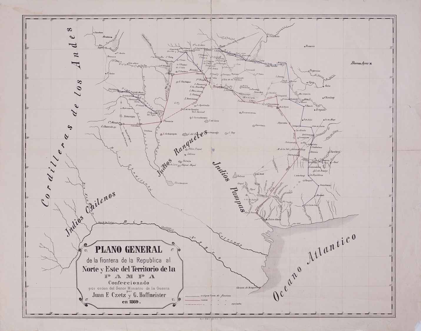
The Minister of War of Argentina commissioned this map, which was created by Juan F. Czetz and G. Hoffmeister in 1869. It depicts the geography of what is now central Argentina or part of the provinces of Buenos Aires (with the city of Bahia Blanca to the south), Santa Fe (with the city of Rosario marked in the map), Córdoba (see Rio Tercero in the north of the map), La Pampa, Mendoza (with Uspallata and Rio Luján marked in the map), and Neuquén. It goes from the Rio Tercero in the North to the Rio Negro in the South. The map shows the previous (in blue) and new (in red) lines of the frontier of the then young Argentina Republic.
With its founding constitution from 1853, the Argentina Republic was just 16 years old at the time this map was drawn. Red dotted lines (to the south and west of parts of the red border) represent new “variable” borders. In fact, all these borders were contested. Those the army called “Indios Ranqueles,” “Indios Pampas,” and “Indios Chilenos” – the Indigenous or Originary peoples we today identify as Ranqueles, Mapuches, and Tehuelches– inhabited this region at the time, as the map shows. The blue and red lines are dotted by forts and military posts (Fortin or Fin. and Fuerte or Fte. or Fe.). See, for example: Fortin, Fin. S.Ignacio, Fte. San Rafael, Fte.Nuevo, Fte. Pampa del Tigre, F.Necochea, Fe.F.Sarmiento, and Fte. Pringles. Along the red and dotted red lines we also see distances (measured in leguas—or leagues, one league is about 3 miles or 5 kilometers). There are, moreover, names of places that depict possible Indigenous occupation such as Toldos viejos, in addition to the regions marked with the Indigenous populations’ names. As we can see, the extension of the frontier west and south and the war campaign of the Argentine Republic collided with the territories occupied by these Indigenous populations. The military campaign known as the Conquista del Desierto (Conquest of the Desert) would start just over a decade later, in 1878. This map is particularly interesting in that it shows the strategic decision of the Argentine government to expand its borders by removing Indigenous communities and occupying their lands.
Map citation
Czetz, Juan, and G. Hoffmeister. Plano general de la frontera de la República al norte y este del territorio de la Pampa. Map, 50 x 62 cm. Buenos Aires, 1869. Map collection, Biblioteca Nacional Mariano Moreno Accessed November 1, 2021.
Citation
Cunial, Santiago L., and Tulia G. Falleti. 2024. 'The Frontier of the Argentine Republic to the North and East of the la Pampa Territory in 1869'. Dispossessions in the Americas. https://staging.dia.upenn.edu/en/content/ARG0046Y/